
Pricing Change
New pricing for orders of material from this site will come into place shortly. Charges for supply of digital images, digitisation on demand, prints and licensing will be altered.
Stronetoper


Enclosure (Period Unassigned), Farmstead (Period Unassigned), Kiln (Period Unassigned), Rig And Furrow (Medieval) - (Post Medieval), Structure (Period Unassigned)
Site Name Stronetoper
Classification Enclosure (Period Unassigned), Farmstead (Period Unassigned), Kiln (Period Unassigned), Rig And Furrow (Medieval) - (Post Medieval), Structure (Period Unassigned)
Canmore ID 81417
Site Number NN89NE 1
NGR NN 851 964
Datum OSGB36 - NGR
Permalink http://canmore.org.uk/site/81417


- Council Highland
- Parish Kingussie And Insh
- Former Region Highland
- Former District Badenoch And Strathspey
- Former County Inverness-shire
NN89NE 1 851 964
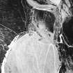
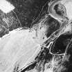
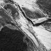
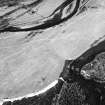
The 1st edition of the OS 6-inch map (Inverness-shire 1872, sheet cii) depicts a single roofless building on the E side of the River Feshie. Up to three roofless buildings and a large enclosure are depicted on the current OS 1:10,000 map.
Information from RCAHMS (P McK) 5 January 1995.
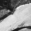
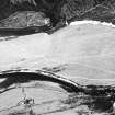
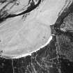
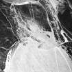
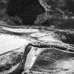
Aerial photography (RCAHMSAP 1995) has recorded faint traces of rig and furrow cultivation on the valley floor in the area immediately to the N of Stronetoper farmstead (NN89NE 1). The rig is visible from the farmstead to NN 851 968, 400m to the N.
Information from RCAHMS (KB) 29 April 1999
Site identified during an archaeological survey of Glen Feshie. A total of 27 settlements (or clusters of buildings) were recorded, with a total of 293 individual archaeological features.
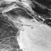
NN 851 964 The settlement is situated on the valley floor on the east bank of the River Feshie at the south end of an extensive linear area of improved ground on which evidence of rig and furrow cultivation is seen. The settelemtn is comprised of 6 structures, 1 corn drying kiln, 1 enclosure.
M. Marshall, October 2003.

