|
Manuscripts |
MS 818/1 |
|
Glenfeshie Estate, In-house archaeological assessment |
1994 |
Item Level |
|
|
Photographs and Off-line Digital Images |
C 41385 |
RCAHMS Aerial Photography |
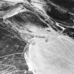
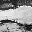
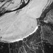
Stronetoper, oblique aerial view, taken from the NE, centred on the remains of a farmstead. Parts of a township are visible in the centre right of the photograph. |
9/2/1995 |
Item Level |
|
|
Photographs and Off-line Digital Images |
C 41386 |
RCAHMS Aerial Photography |
Stronetoper, oblique aerial view, taken from the N, centred on the remains of a farmstead. Parts of a township are visible in the right half of the photograph. |
9/2/1995 |
Item Level |
|
|
Photographs and Off-line Digital Images |
C 41387 |
RCAHMS Aerial Photography |
Stronetoper, oblique aerial view, taken from the NNW, centred on the remains of a farmstead. Parts of a township are visible in the bottom right-hand corner of the photograph. |
9/2/1995 |
Item Level |
|
|
Photographs and Off-line Digital Images |
C 41388 |
RCAHMS Aerial Photography |
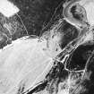
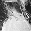
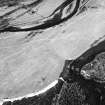
Stronetoper, oblique aerial view, taken from the SW, centred on the remains of a township. A farmstead is visible in the top right-hand corner of the photograph. |
9/2/1995 |
Item Level |
|
|
Photographs and Off-line Digital Images |
C 41391 |
RCAHMS Aerial Photography |
Stronetoper, oblique aerial view, taken from the E, centred on the remains of a township. Part of a farmstead is visible in the bottom right-hand corner of the photograph. |
9/2/1995 |
Item Level |
|
|
Photographs and Off-line Digital Images |
C 41392 |
RCAHMS Aerial Photography |
Stronetoper, oblique aerial view, taken from the NNE, centred on the remains of a farmstead. |
9/2/1995 |
Item Level |
|
|
Photographs and Off-line Digital Images |
C 41394 |
RCAHMS Aerial Photography |
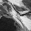
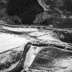
Stronetoper, oblique aerial view, taken from the WNW, showing traces of rig to the north of Stronetoper farmstead. |
9/2/1995 |
Item Level |
|
|
Photographs and Off-line Digital Images |
C 41395 |
RCAHMS Aerial Photography |
Stronetoper, oblique aerial view, taken from the W, showing traces of rig to the north of Stronetoper farmstead. |
9/2/1995 |
Item Level |
|
|
Photographs and Off-line Digital Images |
C 41396 |
RCAHMS Aerial Photography |
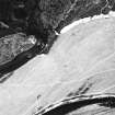
Stronetoper, oblique aerial view, taken from the SSE, showing traces of rig to the north of Stronetoper farmstead. |
9/2/1995 |
Item Level |
|
|
Photographs and Off-line Digital Images |
C 41397 |
RCAHMS Aerial Photography |
Stronetoper, oblique aerial view, taken from the SE, showing traces of rig to the north of Stronetoper farmstead. |
9/2/1995 |
Item Level |
|
|
Manuscripts |
MS 2065 |
Records from North of Scotland Archaeological Society (NOSAS), Highland, Scotland |
Report of an archaeological survey of Glen Feshie, Inverness-shire, Highland. |
10/2003 |
Item Level |
|
 |
On-line Digital Images |
SC 1702710 |
RCAHMS Aerial Photography |
Stronetoper, oblique aerial view, taken from the NE, centred on the remains of a farmstead. Parts of a township are visible in the centre right of the photograph. |
9/2/1995 |
Item Level |
|
 |
On-line Digital Images |
SC 1702711 |
RCAHMS Aerial Photography |
Stronetoper, oblique aerial view, taken from the N, centred on the remains of a farmstead. Parts of a township are visible in the right half of the photograph. |
9/2/1995 |
Item Level |
|
 |
On-line Digital Images |
SC 1702712 |
RCAHMS Aerial Photography |
Stronetoper, oblique aerial view, taken from the NNW, centred on the remains of a farmstead. Parts of a township are visible in the bottom right-hand corner of the photograph. |
9/2/1995 |
Item Level |
|
 |
On-line Digital Images |
SC 1702713 |
RCAHMS Aerial Photography |
Stronetoper, oblique aerial view, taken from the SW, centred on the remains of a township. A farmstead is visible in the top right-hand corner of the photograph. |
9/2/1995 |
Item Level |
|
 |
On-line Digital Images |
SC 1702716 |
RCAHMS Aerial Photography |
Stronetoper, oblique aerial view, taken from the E, centred on the remains of a township. Part of a farmstead is visible in the bottom right-hand corner of the photograph. |
9/2/1995 |
Item Level |
|
 |
On-line Digital Images |
SC 1702717 |
RCAHMS Aerial Photography |
Stronetoper, oblique aerial view, taken from the NNE, centred on the remains of a farmstead. |
9/2/1995 |
Item Level |
|
 |
On-line Digital Images |
SC 1702718 |
RCAHMS Aerial Photography |
Stronetoper, oblique aerial view, taken from the WNW, showing traces of rig to the north of Stronetoper farmstead. |
9/2/1995 |
Item Level |
|
 |
On-line Digital Images |
SC 1702719 |
RCAHMS Aerial Photography |
Stronetoper, oblique aerial view, taken from the W, showing traces of rig to the north of Stronetoper farmstead. |
9/2/1995 |
Item Level |
|
 |
On-line Digital Images |
SC 1702720 |
RCAHMS Aerial Photography |
Stronetoper, oblique aerial view, taken from the SSE, showing traces of rig to the north of Stronetoper farmstead. |
9/2/1995 |
Item Level |
|
 |
On-line Digital Images |
SC 1702721 |
RCAHMS Aerial Photography |
Stronetoper, oblique aerial view, taken from the SE, showing traces of rig to the north of Stronetoper farmstead. |
9/2/1995 |
Item Level |
|


