
Scheduled Maintenance
Please be advised that this website will undergo scheduled maintenance on the following dates: •
Tuesday 3rd December 11:00-15:00
During these times, some services may be temporarily unavailable. We apologise for any inconvenience this may cause.
Black Bothy


Building(S) (Post Medieval), Shieling Hut(S) (Post Medieval)
Site Name Black Bothy
Classification Building(S) (Post Medieval), Shieling Hut(S) (Post Medieval)
Alternative Name(s) Mar Lodge Estate; Boandu Geoldie; Bothan Dubh; Allt A' Chaorainn
Canmore ID 81012
Site Number NN98NW 3
NGR NN 9232 8682
NGR Description Centred NN 9232 8682
Datum OSGB36 - NGR
Permalink http://canmore.org.uk/site/81012


- Council Aberdeenshire
- Parish Crathie And Braemar
- Former Region Grampian
- Former District Kincardine And Deeside
- Former County Aberdeenshire
Measured Survey (23 July 1993)
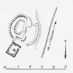
RCAHMS surveyed the building at Black Bothy on 23 July 1993 at a scale of 1:250. The resultant plan was redrawn in ink and published at a scale of 1:500 (RCAHMS 1995b, Fig.24).
Field Visit (4 May 1993)
NN98NW 3 centred 9232 8682
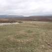
On generally flat grassland along the banks of the Allt a' Chaorainn, some 350m S of its confluence with the Geldie Burn, and at the end of the modern track leading W from Geldie Lodge, there is a group of structures comprising at least two buildings and fifteen huts.
The buildings stand on the W side of the burn, at NN 9226 8678 and belong to different periods. The earlier building (MAR93 153) measures 9.5m from NNE to SSW by 7.6m transversely over a turf-and-stone wall now spread to 2.9m in thickness, though a robber trench on the ESE side suggests that it was originally 0.8m in thickness. On the ESE side there is a small enclosure; stubs of a stony bank, perhaps the remains of an earlier structure, protrude from beneath the corners of the building.
The second building (MAR93 154) stands about 3m to the S of the first, and overlies a short stretch of bank which springs from the SW corner of the earlier structure. It measures 5.2m from NNE to SSW by 3.8m transversely over faced-rubble walls 0.7m thick. The interior has been divided into two compartments.
To the NW of the earlier building there are the robbed remains of what may be another building, measuring 10.5m in length by 5.5m in breadth over turf-and-stone walls spread to 1.2m in thickness. It appears to have a later platform built into its NW end.
The huts are situated on the E side of the burn, disposed in a rough line some 250m long. They are mostly subrectangular in shape, and range in length from 3.6m to 9.5m and in breadth from 2.6m to 5.5m over turf and stone walls generally measuring between 0.7m and 1.5m in thickness. There is some evidence that they are not all contemporary: MAR93 144 overlies MAR93 143 (NN 9235 8686), and there may be an earlier hut partly overlain by MAR93 146 (NN 9235 8689).
John Farquharson's map of the Forest of Mar (National Library of Scotland: Map Library) indicates this site, which he names 'Boandu Geoldie', 'Boandu' probably being a contraction of 'Bothan Dubh'- Black Bothy, which is the name found on the current OS 1:10,000 sheet. One building is depicted, roofless with a bench mark on its SSW end wall, on the 1st edition of the OS 6-inch map (Aberdeenshire 1869, sheet xcvi); this is probably MAR93 154.
(MAR93 136-154)
Visited by RCAHMS (SDB) 4 May 1993.
Field Visit (2022)
NN 92320 86820 A walkover survey was commissioned by The National Trust for Scotland, ahead of a tree planting scheme at the Black Bothy and shielings (Canmore ID: 81012), Mar Lodge Estate, Braemar. The survey was designed to identify and record visible archaeological remains near the Black Bothy and shielings in order to inform a tree-planting scheme. A basic survey was carried out on existing structures, noted within the HER at this location. The survey aimed to provide data including the location, character and extent of these features. The survey also sought to identify previously unrecorded sites, located along the Allt a’ Chaorainn burn, which may pertain to the Black Bothy and shielings site. The walkover survey identified and recorded fourteen features including structures, a mound and shallow pits.
Archive: NRHE and Aberdeenshire HER (intended)
Funder: The National Trust for Scotland
Lachlan Mckeggie and James McGovern – Highland Archaeology Services
(Source DES Volume 23)

