
Swan: Duart Point, Sound Of Mull


Warship (17th Century)
Site Name Swan: Duart Point, Sound Of Mull
Classification Warship (17th Century)
Alternative Name(s) Hms Swan; Duart Castle; 'duart Point Wreck'; Unknown; Swan (Probably)
Canmore ID 80637
Site Number NM73NW 8005
NGR NM 74808 35460
Datum WGS84 - Lat/Long
Permalink http://canmore.org.uk/site/80637


First 100 images shown. See the Collections panel (below) for a link to all digital images.
- Council Argyll And Bute
- Parish Maritime - Argyll And Bute
- Former Region Strathclyde
- Former District Maritime
- Former County Not Applicable
This shipwreck is believed to be that of the Swan, a small warship built in 1641 and lost during Cromwell’s suppression of Royalist support in the Highlands and, in particular, during an attempt to capture Duart Castle (NM73NW 1), the seat of Clan Maclean.
Part of a six strong flotilla, the Swan foundered whilst anchored during a storm on the 13th of September 1653. A further two ships were sunk (‘Martha and Margaret’ NM73NE 8013; ‘Speedwell’ NM73NE 8012) and the others scattered.
Naval diving instructor John Dadd located the wreck in 1979 and material subsequently raised included a Bellarmine flagon. Dadd reported the wreck to the Archaeological Diving Unit (ADU) in 1991 and the site was designated the following year. Rescue excavation by Colin Martin and the ADU took place between 1992 and 2003.
The wreck has survived particularly well, and organic items such as leather and wood were among the artefactual assemblage, alongside armaments, coins, and unusual items such as a pocket watch. One of the most important discoveries was carved decoration from the ship’s exterior that included symbols associated with the Stuart monarchy, indicating the ship’s past history, and setting it apart from the other’s lost in the storm.
Finds from the excavation, along with items from John Dadd’s collection, are held at the National Museum of Scotland. RCAHMS holds a number of photographs, manuscripts and drawings.
Information from RCAHMS (HDS and GFG) 6 November 2012
Martin, CJM 1996
Martin, CJM 2004
Loss (13 September 1653)
Diver Inspection (February 1979)
This wreck was discovered in February 1979 by John Dadd, a naval diving instructor, who located a number of iron guns and an anchor. A number of items were recovered at this time including a Frechen stoneware flagon. The discovery was reported to the Archaeological Diving Unit in 1991.
Information from RCAHMS (HDS) 7 January 2013
Source: C J M Martin 1995
Project (7 June 1991 - 2001)
Survey and trial excavation of a wreck and seven cannons at Duart Point by the Archaeological Diving Unit (ADU).
Diver Inspection (June 1992)
A further visit by the ADU was carried out in 1992. The result of which showed immediate action to protect the site was required, and a week long rescue operation was implemented at which time 83 items were recovered.
Information from RCAHMS (HDS) 7 January 2013
Source: C J M Martin 1992
External Reference (5 May 1992)
Became a Designated Historic Shipwreck on 5 May 1992.
The designation restricts diving, anchoring, fishing and any other activities which may impact on the area within 75m of the position 56 27.45N 5 39.32W, unless under special licence from Historic Scotland.
(Undated) information from Historic Scotland.
Reference (1992)
The remains of a small shipwreck close to the shore were located by John Dadd in 1979, and some recoveries of material subsequently took place. The most recent, in 1992, was by members of the Dumfries and Galloway Branch of the Scottish Sub-aqua Club. Acting on Mr Dadd's information, the site was visited in 1991 by the Archaeological Diving Unit, as a result of which it was designated under the Protection of Wrecks Act (1973) by Historic Scotland. Because of perceived environmental destabilisation the Archaeological Diving Unit (ADU), on Historic Scotland's behalf and after a pre-disturbance survey, recovered in June 1992 some material considered to be under immediate threat. These recoveries, together with those made by the Dumfries and Galloway Sub-Aqua Club and some items from John Dadd's collection, are now in the possession of the National Museum of Scotland.
The wreck is that of a small armed ship, with various elements of timber structure, stone ballast, and seven cast-iron guns so far identified. Several pieces of decorative carving, including part of the Arms of the Prince of Wales have been recovered. Small finds indicate a mid-17th century date, and include part of a schnaphaunce pistol lock, a pocket watch, a sword hilt, clay pipes, a leather shoe, and domestic items of treen. Some of the finds indicate the presence on board of high-status individuals, and human remains have been noted on the site. No historical context for the wreck has yet been established. Colin Martin now holds an excavation licence for the site from Historic Scotland and investigation is proceeding by way of a consortium which includes the Scottish Institute of Maritime Studies at St Andrews University, the NMS and the Scottish Sub-Aqua Club.
Sponsor: Historic Scotland
C J M Martin 1992.
Diver Inspection (1992)
Unaware of its previous discovery, the wreck was also located by members of the Dumfries and Galloway Sub Aqua Club during a training dive in 1992. At this time several exposed and partially buried items were recovered, all of which are held at the National Museums of Scotland.
Information from RCAHMS (HDS) 7 January 2013
Source: C J M Martin 1995
Reference (1993)
(Location cited as NM 748 355). Strathclyde: Argyll and Bute, Torosay, Mull, Duart Point.
C Martin for Historic Scotland reports the remains of a small shipwreck close to the shore, located by John Dadd in 1979, and that some recoveries of material have taken place. The most recent, in 1992, was by members of Dumfries and Galloway Branch of the Scottish Sub-Aqua Club. The site has been designated under the Protection of Wrecks Act (1973) by Historic Scotland. Because of perceived environmental destabilization, the Archaeological Diving Unit, on Historic Scotland's behalf and after a pre-disturbance survey, recovered some material considered to be under immediate threat. These and previously recovered material are now in the possession of the National Museums of Scotland.
The wreck is that of a small armed ship, with various elements of timber structure, stone ballast, and seven cast-iron guns so far identified. Several pieces of decorative carving, including part of the Arms of the Prince of Wales, have been recovered. Small finds indicate a mid 17th century date and include part of a schnaphaunce pistol lock, a pocket watch, a sword hilt, clay pipes, a leather shoe and domestic items of treen.
Some of the finds indicate the presence on board of high-status individuals and human remains have been noted. No historical context for the wreck has as yet been established. C Martin now holds an excavation licence from Historic Scotland and investigation is proceeding by way of a consortium which includes the Scottish Institute of Maritime Studies at St Andrews University, the National Museums of Scotland and the Scottish Sub-Aqua Club.
M Ponsford 1993.
Diver Inspection (1993 - 1995)
A semi-permanent field base was established in 1993 for further survey and protective sandbagging which took place between then and 1995, when a final season of excavation took place.
Information from RCAMS (HDS) 7 January 2013
Source: C J M Martin 1995
Project (1994 - 2005)
Survey of maritime sites including: Dartmouth: Eilean Rubha an Ridire; Evelyn Rose (Possibly): Ardtornish Point; Glen Carradale: Loch Aline Jetty; Hispania: Sgeir Mor; John Preston: Rubha Dearg; Loch Tearnait, Crannog; Pelican: Calve Island; Rondo: Dearg Sgeir; Shuna: Rubha Aird Seisg; Strathbeg: Cnap A' Chailbhe; Swan: Duart Point; Thesis: Rubha an Ridire; Unknown: Calve Island; Unknown: Scallaslte Bay and a stone quay and Ardtornish.
Specialist Report (1995)
In February 1979 the wreck of an armed wooden sailing ship was recognised by Mr John Dadd, a naval diving instructor, immediately E of Duart Point. A Frechen stoneware flagon was recovered, and the discovery was reported to the Archaeological Diving Unit, Department of Transport in 1991.
Pre-disturbance survey by ADU in 1991 showed the wreck to be situated at the base of a rock face sloping at an angle of about 45 degrees. The archaeological material is situated within a seabed of gravely sand with some intrusive boulders and at a Low Water depth of between 8 and 9.5m. The environment comprises zones of mid- and high-energy, and a tidal set of up to 1.5 knots (but confined mainly to the ebb) runs from E to W across the wreck.
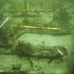
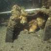
The remains then visible comprised seven heavily-concreted cast-iron guns of up to 2.5m length, a wrought iron anchor, various iron concretions and complexes of concretion, two or possibly three concentrations of stone ballast, and considerable quantities of exposed organic material, including articulated structural elements. The character of the ballast was seen to differ between the two mounds, that to the W comprising large flat slabs, which had evidently been packed with some care, and while the central mound comprised a tumble of smaller and more rounded boulders.
A further visit by ADU in 1992 revealed further extensive destabilisation, and also that the wreck had been independently discovered by members of the Dumfries and Galloway branch of the Scottish Sub-Aqua Club, who had recovered exposed items including pieces of carved wooden decoration and other wooden objects, a hoard of badly-corroded silver coins, a grindstone and the brass lock-plate of a Scottish snaphaunce pistol of mid-17th-century date. Under these circumstances, some 83 further objects were recovered by the National Museums of Scotland.
Six further monitoring visits over the winter of 1992-3 served to demonstrate further erosion, most notably in the sediment-filled gully that slopes towards the shore at the E side of the wreck. A small but complex deposit of rope, a wooden sheave-block, rammer-heads, a shoe, wooden staves and some fine decorated wooden grooved and moulded panelling was investigated and recorded before the area was covered with gravel aggregate.
A semi-permanent field base was established in 1993 for further survey and protective sandbagging which took place between then and 1995. The environmental dynamics around the wreck were seen to be finely balanced but the ongoing activity may be attributed to seismic activity, propeller activity (most significantly from passing ferries) and diver interference, the latter factor being probably the most significant. Erosive activity across the wreck appears to be cyclical, a critical point being reached at the ADU intervention of 1992.
The most significant environmental determinant is the ebb flow which results from the drainage of Duart Bay into the Sound of Mull. This complex flow comprises in essence a smooth run across seaward side of the site which eddies into the part nearest to shore causing the build-up of sediment which has encapsulated the main organic deposits in drifts against the cliff base. It is these sediments which now display the greatest degree of destabilisation, particularly when a spring tide coincides with a strong NW wind. Under these conditions intrusive coarse sand from the wide and shallow areas around Duart Bay is brought to the site where it is both deposited and triggers further erosion with the resulting exposure and displacement of, and mechanical and biological decay of, archaeological objects and deposits. Under these circumstances, sandbagging can only be considered a temporary expedient.
The wreck has also formed the basis for an experimental technical study into the corrosion potential of iron objects, which indicates that the iron cannons are currently corroding rapidly. Similar study has also been carried out into the biodeterioration of both metal and organic materials under the known conditions around the wreck.
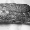
It is evident that a substantial part of the lower forward hull survives as an articulated structure which has been pinned down and preserved by the two main ballast-mounds. On the analogy of the nearby wreck of the Dartmouth (NM74NW 2), it appears probable that the projected rescue excavation within the eastern part of the site will reveal rich deposits of artefactual and other material. High-quality wooden panelling and carvings within this area indicate the collapsed stern.
The discovery of the following artifacts (currently under conservation at the National Museums of Scotland) has been recorded:
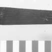
Objects of wood - carvings (all of oak)
1. Badge of the Heir Apparent (to the English throne). 840x281mm, comprises two conjoined pieces in low relief, showing the lower parts of three ostrich feathers enfiling a coronet with a scroll bearing the almost-complete motto ICH DIEN.
2. Two conjoining fragments of carved planking (of total length 972mm) bear a foliated thistle and a seven-stringed harp of Celtic form, the national symbols of Scotland and Ireland respectively. The emblems are separated by scroll borders and the piece is embellished with deeply indented nulling.
3. Warrior head, 460x320mm. This profile in low relief depicts a moustachioed warrior of classical form with curled locks emerging from beneath the neck-guard of a peaked helmet, the top of which would have continued on an adjacent board. An acanthus scroll beyond the neck-guard suggests that the helmet had been garlanded. This motif is common in 17th-century ship decoration, being paralleled in the Vasa and Kronan (Sweden) wrecks.
4. Winged cherub, 460x192mm.
5. Scrolled carving, 1784x180mm, bearing a foliar motif with a petalled flower partly obscured by a diagonal band, and appropriate to the taffrail, gallery surrounds or beakhead.
Objects of wood - other
6. Turned decorative pieces of black locust (Robina pseudoacacia) and possibly to be associated with the carvings or the interior embellishment; some are cut to a flat surface on one side.
7. Barrel costrel of oak with split-willow hoops, length 165mm and maximum restored diameter 110mm. Seven staves and one end survived articulated, the stave that incorporates the stoppered neck being carved in the solid.
8. Two staves of juniper from a flared wooden bucket of height 130mm and restored diameter of about 125mm at the base. The piece had evidently been bound with two split hoops and bears traces of a punched diamond pattern.
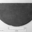
9. Turned wooden bowl of maple, of diameter 135mm and height 76mm, worked to a high standard.
10. Turned wooden bowl of maple, of diameter 102mm and height 62mm.
11. Brush back of oak scrubbing brush, 205x62mm with 60 bristle hoes, arranged in rows of five.
Ceramic objects
12. Hebridean crogan pot of height 226mm, hand-made of buff earthenware with a bag-shaped body and an everted rim of diameter about 200mm, discovered at some distance down-tide from the wreck and not in demonstrable association with it.
13. Frechen Bartmann jug of rim diameter 38mm and height 210mm, in reddish-grey stoneware with characteristic dark brown salt glaze. The sprigged face-mask has a ladder-type mouth and flowing beard while the medallion incorporates a ten-petalled double rosette, a central six-pointed star and rouletted surround. Paralleled in Batavia (Australia, VOC, 1629), Vergulde Draeck (1656) and Kennemerland (HU67SE 8001) wrecks.
14. Clay pipes. Three unmarked bowls of form consistent with mid-17th century English origin.
15. Brick and tile. Complete brick of size 229x102x51mm and form of 'Tudor' brick of 16th and 17th centuries. Fragments of yellowish tile 15mm thick were also found; both brick and tile were probably associated with the galley hearth and its surround, as on the Dartmouth.
Stone objects
16. Rotary grindstone of coarse sandstone, diameter 700mm, 200mm thick at the centre reducing to 185mm at the rim, with a spindle hole 120mm square. Not quite circular, with evidence of use on horizontal surfaces and on sides close to the edge.
17. ?Touchstone. Hard fine-grained stone of octagonal shape, 30x17mm, with long scratch marks on both faces.
Metal objects
18. Brass lock-plate from a left-handed snaphaunce pistol. Length 175mm, chased with foliar decoration and carries initials GT in a thistle-flanked cartouche. A weapon of distinctively Scottish type, probably bearing the initials of George Thompson (fl. 1639-61), an Edinburgh gunmaker.
19. Copper kettle of two-looped form and rivetted sheet construction, diameter 400mm, height 430mm and approximate capacity 50 litres.
20. Pewter flagon of size 250x130mm and estimated capacity 0.9 litres, with a hinged lid with finial and thumb-piece. A small vessel found in apparent association may be a separate drinking-cup which fitted inside it.
21. Buckles and small brass fittings, including some with parallels on the Batavia.
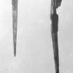
22. Rapier hilt of wire-wound form with spherical pommel and quillons appropriate to an English weapon of the first half of the 17th century, revealed by radiography of a concretion 380mm long.
23. Pocket watch, possibly of 'Puritan' type, revealed by radiography of a circular concretion of diameter 55m and depth 25mm.
24. A 4lb (1.8 kg) lead merchant's weight was found on the wreck during the excavations of 1997. It measures 104mm in diameter by up to 22.5mm in thickness (the basal concavity probably resulting from casting shrinkage). The edges are bevelled and milled, and the upper surface bears marks which comprise the letter C under a crown, a sword and a winged figure holding a sword. The crown can only represent Charles, the sword is the symbol of the City of London and the winged figure is that of the Archangel Michael, this being the seal of the Worshipful Company of Plumbers of London.
Although the concreted hoard of between 300 and 400 silver coins could not be disassembled, the artefactual assemblage indicates a date for the wreck within the earlier part of the 17th century. This date accords with the historically-attested expedition of 1653 by a Commonwealth (Cromwellian) flotilla under Col. Ralph Cobbett to capture Duart Castle (NM73NW 1), the seat of Clan Maclean who retained royalist sympathies.
The distribution of the remains is seen as representing only the wreck of a single ship, and the discovery of such carvings as the badge of the Heir Apparent suggests an identification with the Swan, a fifth-rate warship formerly owned by the Crown. This ship may be identified with a 'pinnace' which was built in 1641, had a crew of 60 and perhaps as many as ten substantial guns, and served on the Irish Sea until 1645. The survival of emblems of royalty into the Commonwealth may be explained by their being placed in store below deck.
The Swan is recorded as being wrecked off Duart Castle in September 1653. She was one of six Cromwellian warships sent (under Col. Ralph Cobbett) to root out Royalist sympathisers. The castle was found deserted and the six ships of the flotilla were scattered in a storm on the 13th September, three being sunk and the remainder dismasted and disabled. The remains of the Martha and Margaret of Ipswich and the Speedwell of Lyn may lie nearby.
C J M Martin 1995; I D MacLeod 1995; D Gregory 1995; C J M Martin 1997b; C Martin 1998a; C Martin 1998b; J P Delgado 1998.
Excavation (1995)
NM 748 356 A final season of excavation was completed in advance of the consolidation and protection of the site from erosion. The lower stern structure was identified, including the bottom part of the rudder, sternpost, and associated components. This assembly had become detached from the keel, and along with the upper afterworks had collapsed towards the port side. Subsequent silting had preserved dislocated pieces of the structure and items from the ship's interior. Debris from the hold had accumulated in this area, particularly in the vicinity of the lower stern, and extensive samples of fish and animal bone were recovered for analysis. Pieces of human bone were also found, apparently belonging to the individual whose remains have been found elsewhere on the site. Investigation below the stone ballast revealed that heather had been used to protect the hull timbers. Artefacts recovered include a slipware bowl, an intact clay pipe bearing the heelmark 'NW' (indicating a Newcastle origin), and a lidded pewter flagon of Scottish manufacture.
A trench was also opened inshore of the forward end of the wreck to determine the nature of collapse in this area. This showed that structural remains and associated artefacts were less well preserved than towards the stern. Nevertheless a general collapse to port could be postulated, and scattered bricks and tiles from the galley structure were noted. Significant quantities of coal and peat were also recovered from this area. An unexpected find is a complete rotary quern, perhaps suggesting that the troops on board the ship had sustained themselves partly from local resources. Pottery finds include a glazed red earthenware chamber pot and a butter crock - apparently with some of its contents in situ - of similar fabric.
At the close of the season 200 sandbags were added to the 500 already placed over the site to protect it from erosion. A programme of regular monitoring is planned.
Report and archive to be deposited in the NMRS.
Sponsor: HS
C Martin 2003.
Reference (1996)
NM 748 356. Work continued on the site of a designated historic shipwreck believed to be that of the Swan, a small warship lost during Cromwell's suppression of the Earl of Glencairn's revolt in support of the Royalist cause in 1653. Pre-disturbance survey was concluded with the completion of contouring at 25cm intervals. In situ stabilisation was initiated on the seven cast-iron guns and a wrought-iron anchor exposed on the sea bed by connecting them to aluminium anodes. Trial excavation was conducted at the E end of the site with the aim of defining its down-tide periphery. Little was found except an isolated deposit of wooden debris which contained the well-preserved rear part of the ships binnacle and the base of a mariner's compass. These finds confirm that this part of the wreck derives from the stern of the ship and that significant parts of the upper structure and its contents, though collapsed, have probably survived within the mobile sediments which lie at the base of the cliff a few metres to the W. Controlled rescue excavation of these deposits will begin in 1997.
Sponsors: Historic Scotland, Russell Trust, Esmee Fairbairn Charitable Trust, Glenfiddich Living Scotland Awards, Honda UK, St Andrews University.
C J M Martin 1996, M Ponsford and R Jackson 1997
Reference (1998)
(No classification specified: date of loss cited as 13 September 1653). Swan: this vessel foundered in a storm whilst anchored at Duart Castle.
(Location of loss cited as N56 28.0 W5 38.0).
I G Whittaker 1998.
Specialist Report (1998)
A 4lb (1.8 kg) lead merchant's weight was found on the wreck during the excavations of 1997. It measures 104mm in diameter by up to 22.5mm in thickness (the basal concavity probably resulting from casting shrinkage). The edges are bevelled and milled, and the upper surface bears marks which comprise the letter C under a crown, a sword and a winged figure holding a sword. The crown can only represent Charles, the sword is the symbol of the City of London and the winged figure is that of the Archangel Michael, this being the seal of the Worshipful Company of Plumbers of London.
C Martin 1998.
Specialist Report (24 April 2002)
Categories of objects recovered from the Swan (1641-1653):
Silver: Coins (mostly corroded beyond identification)
Pewter: Charger; flagons; bottle screw-cap
Brass: Pistol lock-plate; buckles; navigator's dividers; kettle.
Lead: Musket shot; roughened 'burr' shot; window leadings; merchants' weights.
Iron: Small cast-iron gun (? falcon drake); roundshot; various concretions.
Ceramics: Brick and tile; Frechen stoneware; tin-glazed wares; glazed red earthenware; crogan; clay pipes (inc. 'NW' stamped heels from Newcastle); 'ballast' wares (i.e. probably not indigenous to the ship) including Iberian and ?French ceramics.
Glass: Fragments of window-glass.
Stone: Grindstone; small whetstone.
Wood: Powder cartridges ('apostles'); parrel spacer and truck; rigging blocks; sheaves; dead-eyes; decorative carvings; stave-built tankard and lids; stave-built costrel; barrel components; turned bowls; plate; spoon; lantern components; brush head; framed and panelled doors; framed panelling; turned embellishments; pump components; binnacle remains; mariner's compasses; chest; truck carriage; gunport lids; case shot carcass.
Leather: Shoes and fragmentary items.
Textile and fibre: Various textile fragments; rope.
Bone: Human bones (evidently from 1 individual); butchered animal bones.
Environmental: Ballast samples (stone, shingle, clay); dunnage; bilge samples; coal and peat.
Composite: 2 swords; bone-handled knife; pocket watch.
Information from Dr P Martin, 24 April 2002.
Diver Inspection (6 November 2003 - 12 November 2003)
The wreck was visited by Wessex Archaeology between the 6th and 12th November 2003 under a contract for archaeological services issued by Historic Scotland in relation to the Protection of Wrecks Act (1973). Diving took place only on the flood tide, a total time of 249 minutes being achieved. Visibility was consistently good, but the kelp cover was heavier than might be expected in November.
The results represent initial baseline monitoring data, but may not demonstrate that the present site stabilisation measures are satisfactory. However, there appears to be no significant deterioration since the site was visited by ADU in June 2000. The distributions of different species of kelp may indicate areas at risk of erosion. Further monitoring is recommended.
The following position was noted:
Statutory Instrument Position (1992/1229): N56 27.45 W5 39.32 [NM 7480 3546] (OSGB-36)
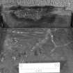
The site lies immediately offshore of the shallow rocky cliff that surrounds Duart Point. From the base of this cliff, the seabed slopes gently offshore until well beyond the known site, where there is a pronounced drop-off. The seabed around the site is fairly level and comprises predominantly sand with isolated spreads of larger material and occasional boulders. Two ballast-mounds were associated with the wreck.
(Detailed recommendations are made; the history of the ship and the study of the remains are summarised. Illustrations include annotated site plan, photo-mosaics and monitoring photographs).
MS/2780.
This wreck was inspected by Wessex Archaeology in 2003, sandbags having previously been laid across the remains. Photo-mosaics of selected areas were generated by the reproduction of frames from digital imagery, and it is hoped to continue monitoring the site in this way over future years.
[Imagery mosaic reproduced].
J Black and S Webster 2004.
Specialist Report (2003)
An iron cannon recovered from the wreck and conserved by T Skinner and S Erpenbeck has been identified as a drake (essentially a lightweight minion with a tapered chamber). Known by the full designation of 'Bastard Minion-Drake Extraordinary', it measures 4ft [1.22m] in length and has a bore of 3.25 ins [83mm]. The piece is marked with the recorded weight of 3cwt 2qtrs 23lb [414 lb or 188kg] and the founder's mark 'I B', identifying the maker as John Browne, royal gunfounder to Charles I. This is the only example of his cast-iron drakes to survive into modern times.
Guns of this type were commonly equipped with skid-fitted carriages to control their very high recoil forces: a carriage of this type was found and is also in conservation. They typically fired anti-personnel projectiles in close-quarter actions and a wooden case containing lead musket balls roughened for this purpose was also found on the wreck.
Metallurgical investigation may also reveal the nature of the 'refined metal' from which such guns were manufactured and which served to justify their high cost.
[Illustrated in colour].
C Martin 2003.
Reference (June 2004)
(Location of centre of wreck cited as N56 27.459 W5 39.398 (WGS84): [NGR NM 7480 3456]). This wreck lies on a seabed of coarse sands and gravels with larger boulders; it is swept by currents during the ebb phase of the tidal cycle. The wreck appears to lie on the junction of zones of accretion and stability, explaining its survival. No evidence of dredging activity was identified.
Remote sensing of this wreck provided an opportunity to test sidescan and multibeam sonar systems against a partially buried wreck excavated and recorded by conventional methods. The multibeam dataset identified the cast iron guns, twin ballast mounds and central depression, but not the anchor. A raised mound (of about 150 sq m extent) was identified about 10m NW of the forward ballast mound. This awaits archaeological investigation, although it may be no more than an extension of the natural sediment accretion previously noted in this area.
Comparison with current site plans demonstrates excellent correspondence, although the non-representation of the cannon indicates partial 'blurring'. The excellent resolution provided is adequate for qualitative survey, but differentiation between geological features and cultural remains difficult, and the resolution obtained (0.1m) is poorer than that offered by traditional methods. It remains questionable whether or not the identification of such remains as cannon might be reliably expected when not previously expected.
(Survey area defined: report illustrated with chart extract and colour sonar imagery).
MS/2338 (pp. 12-18, 24, 86, 92).
External Reference (2004)
(Duart Point: site no. 39). It is believed that the Duart Point wreck is that of the Swan or the Speedwell. A number of items exposed by erosion were raised by the [then] Archaeological Diving Unit in 1992 (on behalf of Historic Scotland, and are under conservation by the National Museums of Scotland.
Advisory Committee on Historic Wreck Sites 2004.
Note (2 May 2008)
Duart Castle (NM73NW 1.00) is at NM 74893 35325.
Information from RCAHMS (RJCM), 2 May 2008.
Reference (2011)
Whittaker ID : 7902
Name : SWAN
Latitude : 562800
Longitude : 53800
Registration : BRITISH
Loss Day : 13
Loss Month : 9
Loss Year : 1653
Comment : Foundered in a storm whilst anchored at Duart Castle
Reference (19 April 2012)
UKHO Identifier : 002760
Feature Class : Wreck
State : DEAD
Classification : Unclassified
Position (Lat/long) : 56.45750,-5.65528
Horizontal Datum : ORDNANCE SURVEY OF GREAT BRITAIN (1936)
WGS84 Position (Lat/long) : 56.45733,-5.65637
WGS84 Origin : 3-D Cartesian Shift (BW)
Position Method : Horizontal sextant angle
Position Quality : Unreliable
Depth Quality : Depth unknown
Water Depth : 10
Vertical Datum : Mean Low Water Springs
Name : UNKNOWN
Contact Description : None reported
Original Sensor : Diver Sighting
Original Detection Year : 1991
Original Source : Other
Surveying Details : **HA141/02/01/03 24.6.91 WKGE OF POSSIBLE MID 17TH CENTURY VESSEL LOCATED IN 562727N, 053919W [OGB]. COMPRISES WOODEN STRUCTURES AND 7 CANNON. (ADU REPORT 91/3, 14.6.91). NCA, POSN FOR FILING ONLY.
POSITIONS BELOW THIS POINT ARE IN DEGREES, MINUTES AND DECIMALS OF A MINUTE
**4.4.00 DUPLICATE RECORD. DETAILS TRANSFERRED TO 2762. THIS RECORD AMENDED TO DEAD.
Chart Symbol : WK
Charting Comments : DUPLICATE RECORD DETAILS TRANSFERRED TO 2762
Date Last Amended : 04/04/2000
Reference (19 April 2012)
UKHO Identifier : 002762
Feature Class : Wreck
State : LIVE
Status : Historic
Classification : Unclassified
Position (Lat/long) : 56.45733,-5.65643
Horizontal Datum : ETRS 1989
WGS84 Position (Lat/long) : 56.45733,-5.65643
WGS84 Origin : Block Shift
Previous Position : 56.45750,-5.65533
Position Quality : Precisely known
Depth Quality : Depth unknown
Water Depth : 10
Vertical Datum : Mean Low Water Springs
Name : SWAN (PROBABLY)
Type : SV (MAN OF WAR)
Flag : ENGLISH
Date Sunk : 13/09/1653
Bottom Texture : Rock
Contact Description : Notable debris
Original Sensor : None reported
Last Sensor : Diver Sighting
Original Detection Year : 1992
Last Detection Year : 2000
Original Source : Other
Last Source : Divers
Circumstances of Loss : **SANK DURING A VIOLENT STORM. WAS PART OF THE FLEET SUPPORTING THE ENGLISH GARRISON WHICH WAS OCCUPYING DUART CASTLE. (SIBI, SHIPWRECKS OF THE W COAST OF SCOTLAND)
Surveying Details : **HA141/02/01/03 24.6.91 WRECKAGE OF POSSIBLE MID 17TH CENTURY VESSEL LOCATED IN 562727N, 053919W [OGB]. COMPRISES WOODEN STRUCTURES AND 7 CANNON. (ADU REPORT 91/3, 14.6.91). FOR FILING ONLY. NCA.
**HA141/002/001/04 3.6.92 DISIGNATED AS AN HISTORIC WK. RESTRICTED AREA RADIUS 75MTRS CENTRED ON 562727.0N, 053919.2W [OGB]. (SI 1151/92). SOFTWOOD PANELLING FOUND ON SITE SEEMS TO INDICATE AN 17TH CENTURY WK. INS AS REST'D AREA WITH NOTE. - NM 1792/92.
**HA141/002/001/05 10.3.93 AN ENTRY IN C H FIRTH'S 'SCOTLAND AND THE COMMONWEALTH' [1895 EDN], P.399-400, INDICATES THAT THIS PROBABLY IS THE WK OF THE ENGLISH MAN OF WAR 'SPEEDWELL'. THE VESSELS SWAN, MARTHA AND MARGARET WERE ALSO LOST ON THE SAME OCCASION BUT WITHOUT LOSS OF LIFE. A SUBSTANTIAL QUANTITY OF HUMAN REMAINS HAVE BEEN FOUND IN THIS WK. (C MARTINE, 18.12.92).
**17.9.96 WK CONSIDERED TO BE THAT OF 'SWAN'. BINNACLE RECOVERED IN GOOD CONDITION WITH SIX INCH COMPASS STILL INTACT. (THE TIMES, 22.8.96).
POSITIONS BELOW THIS POINT ARE IN DEGREES, MINUTES AND DECIMALS OF A MINUTE
**4.4.00 SANDBAGS HAVE BEEN LAID OVER ONE SECTION OF THE WRECK TO PROTECT HUMAN REMAINS. (DIVER MAGAZINE APRIL 2000).
**15.3.07 EUT POSN: 5627.440N, 0539.386W. NE 2390.
Chart Symbol : WK HIS
Charting Comments : REST'D AREA RADIUS 75MTRS. WK NOT CHARTED
Date Last Amended : 12/01/2009
Date Position Last Amended : 12/01/2009
Management (1 November 2013)
The following Historic Marine Protected Area (HMPA) designations will come into force on 1 November 2013. On the same day Section 1 of the Protection of Wrecks Act (1973) will be repealed and the statutory instrument for each designation under the 1973 Act will be revoked – see
Marine (Scotland) Act 2010 (Commencement No.3 and Consequential Provisions Order 2013
http://www.legislation.gov.uk/ssi/2013/276/contents/made
(1) The Duart Point Wreck (NM73NW 8005) is to be designated as the Duart Point HMPA
(2) The Dartmouth (NM74SW 8002) is to be designated as the Dartmouth HMPA
(3) The Mingary Castle Wreck (NM56SW 8001) is to be designated as the Mingary HMPA
(4) HMS Campania (NT28SW 8001) is to be designated as the Campania HMPA
(5) The Kinlochbervie Wreck (NC15SE 8001) is to be designated as the Kinlochbervie HMPA
(6) The Wrangels Palais (HU77SW 8001) and Kennemerland (HU67SE 8001) will be designated as the Out Skerries HMPA (ie two polygons making up one designation).
Also on 1 November 2013, the urgent designation of the Drumbeg wreck (NC13SW 8007) on 18 March 2013 for a period of two years under the provisions of Section 77 of the Marine (Scotland) Act 2010 is to be revoked and replaced by a permanent HMPA designation order.
As it will not progress to Historic MPA status, statutory protection for the site of the Blessing of Burntisland (NT28SW 8008) is to be revoked altogether on 1 November 2013 by virtue of
The Marine (Scotland) Act 2010 (Commencement No. 3 and Consequential Provisions) Order 2013
http://www.legislation.gov.uk/ssi/2013/276/contents/made
Entered by RCAHMS (GF Geddes) 29 October 2013
Information from Historic Scotland (P Robertson) 15 October 2013
Diver Inspection (3 December 2014 - 4 December 2014)
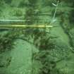
Historic Scotland commissioned Cotswold Archaeology to undertake a designated site assessment of the Duart Point HMPA. Six inspection dives were undertaken. The visible archaeological remains observed were three iron guns at the east end of the site, two ballast mounds, and two iron guns, a small iron gun and an anchor at the west end of the site. Between the two ballast mounds were lines of wood samples that had been placed there to record the species of wood-boring organisms. The previously excavated and sandbagged areas appeared almost completely buried, with only the edges of a small number of bags protruding from the sediments, and one of the previously exposed guns at the west end of the site, now partially buried in sediment. These observations clearly demonstrate that the site has become naturally infilled by sand and fine sediments. A series of sediment monitoring poles were observed running in two parallel lines aligned roughly NW-SE. They took the form of scaffold poles and protruded roughly 1m above the level of the seabed.
Cotswold Archaeology January 2015
Note
Formerly entered as NM73NW 6.
See also NM73NE 8012 and NM73NE 8013.
For nearby Duart Castle, see NM73NW 1.
Excavation

