
Pricing Change
New pricing for orders of material from this site will come into place shortly. Charges for supply of digital images, digitisation on demand, prints and licensing will be altered.
An Dun


Fort (Period Unassigned)(Possible)
Site Name An Dun
Classification Fort (Period Unassigned)(Possible)
Alternative Name(s) Lat 291; An Dun, Borgue
Canmore ID 8044
Site Number ND12NW 14
NGR ND 14102 25647
Datum OSGB36 - NGR
Permalink http://canmore.org.uk/site/8044


- Council Highland
- Parish Latheron
- Former Region Highland
- Former District Caithness
- Former County Caithness
ND12NW 14 14102 25647
(ND 1410 2510) An Dun (NAT)
OS 6" map, (1965)
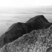
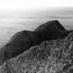
Fort, An Dun, Borgue: Situated on the coast near Borgue is a remarkable rock peninsula, connected to the mainland by a natural bridge at a much lower level than either, and about 6ft wide at the top. The peninsula is a hog-backed ridge lying parallel to the coast line, and sloping steeply to precipitous cliffs on either side, but with the longer slope to seaward, and rising in elevation towards its S end. Only at the highest point is there any level ground and there, only an area about 20ft square. Along the ridge facing the bridge is exposed a section of wall, and there are slight indications of its continuation to S.
RCAHMS 1911.
Generally as described by the RCAHMS, but the wall mentioned would appear to be natural rock strata exposed by considerable erosion which has taken place. There are no traces of any other features of antiquity on this rock.
Visited by OS (W D J) 24 June 1960.
No change.
Visited by OS (R L) 6 March 1968.
No trace of walling.
C Batey 1982.
An Dun is a knife-edged promontory connected by a narrow natural causeway to the land. There is no evidence either on the promontory or the causeway of walling; the wall noted by the RCAHMS appears to be natural rock strata. There are no visible remains to suggest a fort.
Visited by OS (N K B) 6 December 1982.
Field Visit (24 June 1960)
Generally as described by the RCAHMS, but the wall mentioned would appear to be natural rock strata exposed by considerable erosion which has taken place. There are no traces of any other features of antiquity on this rock.
Visited by OS (W D J) 24 June 1960.
Field Visit (6 March 1968)
No change.
Visited by OS (R L) 6 March 1968.
Project (1980 - 1982)
Field Visit (6 December 1982)
An Dun is a knife-edged promontory connected by a narrow natural causeway to the land. There is no evidence either on the promontory or the causeway of walling; the wall noted by the RCAHMS appears to be natural rock strata. There are no visible remains to suggest a fort.
Visited by OS (N K B) 6 December 1982.

