
Poll Gorm


Broch (Iron Age)(Possible), Promontory Fort (Period Unassigned)
Site Name Poll Gorm
Classification Broch (Iron Age)(Possible), Promontory Fort (Period Unassigned)
Alternative Name(s) Lat 281
Canmore ID 8032
Site Number ND12NE 3
NGR ND 1703 2949
Datum OSGB36 - NGR
Permalink http://canmore.org.uk/site/8032


- Council Highland
- Parish Latheron
- Former Region Highland
- Former District Caithness
- Former County Caithness
ND12NE 3 1703 2949.
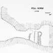
(ND 1703 2949) A promontory fort formed by two banks, 14.0m long and 5.0m wide, crossing the neck of the promontory. On the promontory itself are a possibly secondary, roughly square structure, 13.0 by 14.0m, with traces of walling, a corn-drying kiln, and another small structure.
C Batey 1982.
On the summit of a precipitous coastal promontory are the remains of a fort, comprising a circular dry-stone structure further defended by an outwork cutting across the neck of the promontory on the landward approach from the SW.
The dry-stone structure, about 20.0m overall diameter, survives as a turf-covered bank, 4.0 to 5.0m wide and up to 0.7m high, which has been truncated in the NW arc by erosion of the cliff. The area enclosed by the bank has a somewhat angular appearance (Batey, 1982, describes the feature as 'roughly square'), but this is due, at least in part, to the removal of turf at some time for an unknown reason; this turf-cutting has exposed a single course of stones defining an inner curving wall face for a distance of about 6.0m along the base of the enclosing bank in the S arc. If the curve of the wall were to be extended, it would suggest a diameter of 8.0 to 10.0m. The wall appears to end abruptly at its W end, which may suggest an entrance passage at that point. The 'corn-drying kiln and another small structure' noted by Batey are in fact a look-out post with chimney which is known locally to have been used during the 1939-45 war. It is inserted into the fabric of the fort on the E side, exposing a wall core of local sandstone flags fragmented by weather action.
The outwork consists of a turf-covered stony bank and outer ditch, the former being 1.7m above the base of the ditch. Fronting the ditch is a less significant bank, 0.6m high, which has been partially quarried.
The whole extends for 14.0m across the promontory from the cliff edge in the SE to terminate on a distinct causeway hard against the cliff edge in the NW.
The remains of crude, stone-built, bothy-like structures of unknown date and purpose occur on a shelf at a lower level, SE of the fort.
The fort cannot be classified with certainty without excavation. Its size and shape, the constructional material and the existence of a curving inner wall face may indicate a broch, but, whereas the remains suggest a massive defensive construction, there is insufficient tumble remaining to postulate a monument on the scale of a broch unless there has been large scale robbing and/or erosion. There is no reason to suggest that the fort and outwork are not broadly contemporary.
Surveyed at 1:2500.
Visited by OS (N K B) 24 March 1983.
Project (1980 - 1982)
Field Visit (1982)
(ND 1703 2949) A promontory fort formed by two banks, 14.0m long and 5.0m wide, crossing the neck of the promontory. On the promontory itself are a possibly secondary, roughly square structure, 13.0 by 14.0m, with traces of walling, a corn-drying kiln, and another small structure.
C Batey 1982.
Field Visit (24 March 1983)
On the summit of a precipitous coastal promontory are the remains of a fort, comprising a circular dry-stone structure further defended by an outwork cutting across the neck of the promontory on the landward approach from the SW.
The dry-stone structure, about 20.0m overall diameter, survives as a turf-covered bank, 4.0 to 5.0m wide and up to 0.7m high, which has been truncated in the NW arc by erosion of the cliff. The area enclosed by the bank has a somewhat angular appearance (Batey, 1982, describes the feature as 'roughly square'), but this is due, at least in part, to the removal of turf at some time for an unknown reason; this turf-cutting has exposed a single course of stones defining an inner curving wall face for a distance of about 6.0m along the base of the enclosing bank in the S arc. If the curve of the wall were to be extended, it would suggest a diameter of 8.0 to 10.0m. The wall appears to end abruptly at its W end, which may suggest an entrance passage at that point. The 'corn-drying kiln and another small structure' noted by Batey are in fact a look-out post with chimney which is known locally to have been used during the 1939-45 war. It is inserted into the fabric of the fort on the E side, exposing a wall core of local sandstone flags fragmented by weather action.
The outwork consists of a turf-covered stony bank and outer ditch, the former being 1.7m above the base of the ditch. Fronting the ditch is a less significant bank, 0.6m high, which has been partially quarried.
The whole extends for 14.0m across the promontory from the cliff edge in the SE to terminate on a distinct causeway hard against the cliff edge in the NW.
The remains of crude, stone-built, bothy-like structures of unknown date and purpose occur on a shelf at a lower level, SE of the fort.
The fort cannot be classified with certainty without excavation. Its size and shape, the constructional material and the existence of a curving inner wall face may indicate a broch, but, whereas the remains suggest a massive defensive construction, there is insufficient tumble remaining to postulate a monument on the scale of a broch unless there has been large scale robbing and/or erosion. There is no reason to suggest that the fort and outwork are not broadly contemporary.
Surveyed at 1:2500.
Visited by OS (N K B) 24 March 1983.
Publication Account (2007)
ND12 7 POLL GORM
ND/1703 2949
Possible broch in Latheron, Caith-ness, on a precipitous coastal cliff pro-montory. Little can be seen but the remains suggest a circular drystone structure about 20m in overall diameter. A single course of stones on the south may be the inner wallface. There are outer defences consisting of two banks 14.0m long and 5.0m wide crossing the neck of the promontory. The site could be a broch either within a promontory fort or with outer defences.
Sources: 1. NMRS site no. ND 12 NE 3: 2. Batey (ms) 1982, no. 281.
E W MacKie 2007
Note (12 February 2015 - 31 May 2016)
Access to this precipitous promontory on the cliffs on the N side of the mouth of Dunbeath Bay is barred on the SW by a rampart with an external ditch and a counterscarp bank. The crest of the inner rampart stands about 1.7m above the bottom of the ditch, and a gap for the entrance has been left along the NW margin of the promontory. The interior measures about 50m from NE to SW by 20m transversely (0.08ha) and rises towards the NE, where there is what may be the stump of a broch on the summit. The latter measures about 8m across within a wall reduced to a bank of rubble about 5m thick. A WWII lookout post has been constructed in its seaward flank on the SE.
Information from An Atlas of Hillforts of Great Britain and Ireland – 31 May 2016. Atlas of Hillforts SC2810

