Accessibility

Font Size

100% 150% 200%

Background Colour

Default Contrast
Close Reset

Glasgow, Central Station, New Approach Viaduct

Railway Bridge(S) (19th Century) - (20th Century)

Site Name Glasgow, Central Station, New Approach Viaduct

Classification Railway Bridge(S) (19th Century) - (20th Century)

Alternative Name(s) River Clyde; Caledonian Railway Bridge; Glasgow, Central Station, New Railway Bridge; Broomielaw; Clyde Place

Canmore ID 79857

Site Number NS56SE 140.01

NGR NS 58688 64801

Datum OSGB36 - NGR

Permalink http://canmore.org.uk/site/79857

Ordnance Survey licence number AC0000807262. All rights reserved.
Canmore Disclaimer. © Bluesky International Limited 2025. Public Sector Viewing Terms

Toggle Aerial | View on large map

Digital Images

Glasgow, Central Station Railway Bridge
View from NE showing remains of Central Railway Station Bridge with Caledonian Bridge in background
Glasgow, Central Station Railway Bridge
View from NE showing remains of Central Railway Station Bridge with Caledonian Bridge in backgroundOblique aerial view centred on the railway bridge and road bridges, taken from the NE.Oblique aerial view centred on the railway bridge and road bridges, taken from the N.General oblique aerial view of Glasgow centred on the vaiduct, taken from the SSW.Oblique aerial view.View from NWView from WNWView from Clyde Place, Glasgow of the Central Station Bridge during construction, September 1902 (completed 1905). This was built for the Caledonian Railway Company to their design as part of the reconstruction of the Station. An earlier bridge built also by Arrol (1875-8) for the Caledonian Railway is just visible in the centre background. Its girders and decking had to be jacked up by 3 feet in order to achieve the rail level of the new bridgeGeneral oblique aerial view of the city looking along the river, taken from the W.George the Fifth Bridge, Glasgow, also showing Glasgow Bridge and the Approach Viaduct to Central Station.  Oblique aerial photograph taken facing east.George the Fifth Bridge and New Approach Viaduct, Glasgow.  Oblique aerial photograph taken facing north.View of underside of viaduct, on south bank.Close-up view of partly erased graffiti on a pier.General oblique aerial view of the city looking along the river, taken from the E.George the Fifth Bridge, New Approach Viaduct and Glasgow Bridge, Glasgow.  Oblique aerial photograph taken facing east.George the Fifth Bridge, New Approach Viaduct and Glasgow Bridge, Glasgow.  Oblique aerial photograph taken facing east.  This image has been produced from a damaged negative.View from E  showing partly erased graffiti on a pier (mid-distance).View from S of graffiti on underside of the west side of the N end of the viaduct.General oblique aerial view of the city looking along the river, taken from the E.Oblique aerial view centred on the railway bridge and road bridges, taken from the E.View of Central Station bridge, Glasgow
Oblique aerial view of the New Approach Viaduct, Glasgow Bridge, George The Fifth Bridge and Old Approach Viaduct, looking NW.Oblique aerial view.Detail of graffiti high up on the east face of the decking.View from N of graffiti on a pier on the west side of the N end of the viaduct.General oblique aerial view of the city with the bridges in the foreground, taken from the SW.Glasgow, general view, showing Glasgow Bridge, New Approach Viaduct and George the Fifth Bridge.  Oblique aerial photograph taken facing north.Central Station and George the Fifth and Glasgow Bridges, Glasgow.  Oblique aerial photograph taken facing north-east.  This image has been produced from a print.Oblique aerial view.Detail of graffiti above a pier on the east side of the viaduct.Glasgow, Central Station Railway Bridge
View looking SSW showing remains of Central Railway Station Bridge with Glasgow Bridge on left and Caledonian Bridge on rightOblique aerial view centred on the railway bridge and road bridges, taken from the ENE.George the Fifth Bridge, New Approach Viaduct and Glasgow Bridge, Glasgow.  Oblique aerial photograph taken facing east.Glasgow Bridge, New Approach Viaduct and George the Fifth Bridge, Glasgow.  Oblique aerial photograph taken facing south.George the Fifth Bridge, New Approach Viaduct and Glasgow Bridge, Glasgow.  Oblique aerial photograph taken facing east.Glasgow Bridge to Kingston Dock Glasgow, Lanarkshire, Scotland. Oblique aerial photograph taken facing West. This image was marked by AeroPictorial Ltd for photo editing.View from E.Oblique aerial view of the shopping centre and the station, taken from the SSE.General oblique aerial view of the city looking along the river, taken from the ESE.Oblique aerial view centred on the shopping centre with the bridges adjacent, taken from the NNE.Oblique aerial view centred on the railway bridge and road bridges, taken from the N.Oblique aerial view of the city centre showing M74 extension going through the Port Eglinton area to the M74 centred on the Eglinton Street goods station, taken from the S.George the Fifth Bridge, New Approach Viaduct and Glasgow Bridge, Glasgow.  Oblique aerial photograph taken facing north-east.  This image has been produced from a damaged negative.George the Fifth Bridge, New Approach Viaduct and Glasgow Bridge, Glasgow.  Oblique aerial photograph taken facing north.View from S of graffiti on a pier on the west side of the N end of the viaduct.View from NW showing locomotive 46200 crossing bridgeGeneral oblique aerial view of the city looking along the river, taken from the W.Oblique aerial view centred on the railway bridge and road bridges, taken from the NNE.General oblique aerial view of the city looking along the river, taken from the E.General oblique aerial view of Glasgow looking along the river, taken from the E.

View includes Millennium Bridge, Finnieston Bridge, Bell's Bridge, Central Station Viaduct, George the Fifth Bridge, Albert Bridge, Victoria Bridge, Union Railway Bridge, South Portland Street Suspension Footbridge, Glasgow Bridge and Kingston Bridge.General oblique aerial view of Glasgow centred on the vaiduct, taken from the SSW.George the Fifth Bridge, New Approach Viaduct and Glasgow Bridge, Glasgow.  Oblique aerial photograph taken facing south-east.Glasgow Bridge to Broomielaw from SE Glasgow, Lanarkshire, Scotland. Oblique aerial photograph taken facing North/West. This image was marked by AeroPictorial Ltd for photo editing.Oblique aerial view of the Clyde Viaduct, Glasgow Bridge, George the Fifth Bridge and New Approach Viaduct, looking SE.View of underside of viaduct, on south bank.Detail of graffiti above a pier on the east side of the viaduct..

Administrative Areas

  • Council Glasgow, City Of
  • Parish Glasgow (City Of Glasgow)
  • Former Region Strathclyde
  • Former District City Of Glasgow
  • Former County Lanarkshire

Archaeology Notes

NS56SE 140.01 58688 64801

Location formerly cited as NS 5870 6471 to NS 5873 6486.

For adjacent (to N) and associated Central Station, see NS56SE 77.00.

For (superseded) signal box (situated at NS 58682 64783, on W approach viaduct), see NS56SE 2183.

Length 752 ft [229m] , average width 120 ft [36.6m], steel content 11,000 tons, principal spans 160 ft [48.8m] , 200 ft [61m], 178 ft [53.4m]. Built for Caledonian Railway into Glasgow Central Station, alongside an earlier bridge (NS56SE 140.00), also built by Sir William Arrol and Co. in 1875-1878.

(Undated) informnation in NMRS.

This bridge was designed by D.A. Matheson, chief engineer of the Caledonian Railway. It was built 1899-1905 by Sir William Arrol and Company and is of steel with granite piers founded on five steel caissons.

Sir William Arrol & Co, 1909; J R Hume 1974.

(Central Station Bridges). The present [second] bridge was built 1899-1905 [for the Caledonian Railway], and is of much more substantial steel construction [than the earlier bridge], on granite piers, each of which is founded on five steel caissons. It also was built by Arrol and Co.

J R Hume 1974.

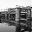
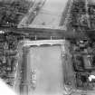
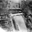
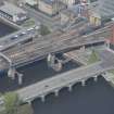
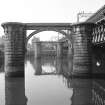
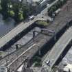
(Central Station Bridges). The second bridge was built in 1899-1905, when the station [Central Station] was enlarged (engineer Donald A Matheson, of the Caledonian Rly Co; contractors Sir Wm Arrol and Co, and Morrison and Mason). It carries up to ten tracks, the width varying from 35 to 62.5m (114 to 205ft), with a minimum of eight parallel main girders in the width. The facades are enlivened by the cantilevering of latticework parapets from the main girders on large curved brackets, throwing the heavier steelwork into shadow.

The main structure spreads low over the Broomielaw quay below, a dark and complex monster of steel. Each of the two supports in the river is a line of five granite-faced cylinders linked by arches just above low-water level. Deep underneath are rectangular steel caissons covering the whole area of the piers, and filled up with concrete and brickwork. They were sunk by the compressed air process to a firm sand and gravel stratum at depths 12 to 21m (40 to 70ft) below high water.

E Williamson, A Riches and M Higgs 1990.

The earlier (E) of these two bridges was opened on 1 August 1879 to allow Caledonian Rly access to the (new) Central Station (NS56NE 77.00). As part of the (1899-1905) expansion of Central Station a second bridge (of comparable appearance) was added on the W. The new bridge was brought into use in March 1905. At the same time, the old bridge was re-floored to bring it up to the height of the new. Re-signalling in 1960 and 1966 rendered it redundant, and it was demolished; the new bridge remains in use.

M Smith 1994.

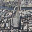
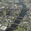
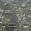
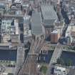
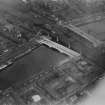
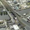
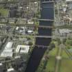
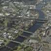
Although commonly termed a viaduct, this structure is more properly to be considered a bridge. It carries the approach tracks of the former Caledonian Rly main line across the River Clyde into Central Station (NS56NE 77.00), immediately to the N, and thus forms the most northerly portion of the now-electrified West Coast Main Line (from London, Euston).

The location assigned to this record defines the centre of the former span. The high approaches on each side render the extent of the structure unclear, but the available map evidence suggests that it extends from NS c. 58710 64914 to NS c. 58610 64703. The N end of the viaduct carries the S (approach) end of the longer platforms over the Broomielaw, while the S end crosses Clyde Place.

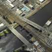
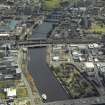
This bridge forms the central element of the tightly-spaced group of bridges across the River Clyde in central Glasgow, between the Upper and Lower Harbours. The river here forms the boundary between the parishes of Glasgow (to the N) and Govan (to the S).

Information from RCAHMS (RJCM), 19 December 2005.

Activities

Construction (1899 - 1905)

Sir John Wolfe-Barry - consultant engineer

Project (2007)

This project was undertaken to input site information listed in 'Civil engineering heritage: Scotland - Lowlands and Borders' by R Paxton and J Shipway, 2007.

Publication Account (2007)

The present viaduct, immediately adjoining the first, was erected from 1899–1905, and comprises steel Linville trusses in three spans. The central truss spans 194 ft and is 15 ft 9 in. deep. The parapet girders are of traditional lattice construction and about 10 ft deep. Each river pierconsists of five granite-faced concrete columns resting on blue brick columns resting upon concrete-filled steel caissons sunk, partly by means of excavation within a compressed air chamber, to foundation level at a depth of about 44–48 ft below the river bed.

The considerable width of the viaduct, which carries ten tracks and varies from 118–205 ft supported on eight parallel main girders, resulted from the enlargement of Central Station from that achieved under the direction of Caledonian Railway engineer George Graham in 1890. The engineers were D. A. Matheson, Caledonian Railway and Sir Wolfe Barry, consulting. The contractors were Sir William Arrol & Co. & Morrison and Mason.

R Paxton and J Shipway 2007

Reproduced from 'Civil Engineering heritage: Scotland - Lowlands and Borders' with kind permission of Thomas Telford Publishers.

Field Visit (28 September 2017)

There are numerous tags, written in spray paint and marker pen, on the piers and substructure of the north end of the railway viaduct.

Visited by HES Survey and Recording (JRS, AMcC) 28 September 2017.

References

MyCanmore Image Contributions


Contribute an Image

MyCanmore Text Contributions