
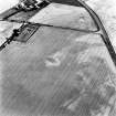
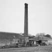
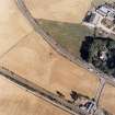
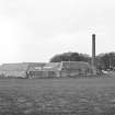
Allanfearn, Farm Steading And Chimney


Chimney (Period Unassigned), Farmstead (Period Unassigned)
Site Name Allanfearn, Farm Steading And Chimney
Classification Chimney (Period Unassigned), Farmstead (Period Unassigned)
Canmore ID 79723
Site Number NH74NW 60.01
NGR NH 71748 47446
Datum OSGB36 - NGR
Permalink http://canmore.org.uk/site/79723


- Council Highland
- Parish Inverness And Bona
- Former Region Highland
- Former District Inverness
- Former County Inverness-shire
NH74NW 60.01 71748 47446
See Architecture.
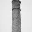
(Location cited [incorrectly] as NH 707 474). Farm chimney, Allanfearn, mid 19th century. A typical circular brick chimney, with beaded top, with the ruins of an engine and boiler house.
J R Hume 1977.

