|
Photographs and Off-line Digital Images |
A 63773 PO |
Papers of Professor John R Hume, economic and industrial historian, Glasgow, Scotland |
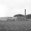
Allanfearn Farm
View from E showing chimney and farm buildings |
12/5/1974 |
Item Level |
|
|
Photographs and Off-line Digital Images |
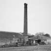
B 14310 |
|
Chimney from east |
24/5/1989 |
Item Level |
|
|
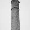
Photographs and Off-line Digital Images |
B 14311 |
|
Chimney from east |
24/5/1989 |
Item Level |
|
 |
On-line Digital Images |
SC 434952 |
Papers of Professor John R Hume, economic and industrial historian, Glasgow, Scotland |
Allanfearn Farm
View from E showing chimney and farm buildings |
12/5/1974 |
Item Level |
|
|
Manuscripts |
MS 749/220 |
Papers of Professor John R Hume, economic and industrial historian, Glasgow, Scotland |
John R Hume Industrial/CBA cards
Filed under Inverness-shire, Inverness and Bona parish. Contact print attached (Hume photo index number H74/120/2). (see NMRS MS/749 entry for Collection description) |
12/5/1974 |
Item Level |
|
|
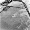
Photographs and Off-line Digital Images |
C 46997 CN |
RCAHMS Aerial Photography |
Culloden, oblique aerial view, taken from the WNW, centred on a pit-alignment and other cropmarks and the remains of a chambered cairn. Culloden railway station and Allanfearn farm are visible in the bottom and top right-hand corners of the photograph. |
10/8/1995 |
Item Level |
|
|
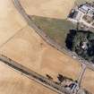
Photographs and Off-line Digital Images |
C 53565 |
RCAHMS Aerial Photography |
Allanfearn, oblique aerial view, taken from the ESE, centred on cropmarks, including an enclosure and a pit-setting. Allanfearn Farm is visible in the top left-hand corner of the photograph. |
10/8/1995 |
Item Level |
|
 |
On-line Digital Images |
SC 1695970 |
RCAHMS Aerial Photography |
Culloden, oblique aerial view, taken from the WNW, centred on a pit-alignment and other cropmarks and the remains of a chambered cairn. Culloden railway station and Allanfearn farm are visible in the bottom and top right-hand corners of the photograph. |
10/8/1995 |
Item Level |
|
 |
On-line Digital Images |
SC 1695981 |
RCAHMS Aerial Photography |
Allanfearn, oblique aerial view, taken from the ESE, centred on cropmarks, including an enclosure and a pit-setting. Allanfearn Farm is visible in the top left-hand corner of the photograph. |
10/8/1995 |
Item Level |
|
 |
On-line Digital Images |
SC 2558683 |
|
Chimney from east |
24/5/1989 |
Item Level |
|
 |
On-line Digital Images |
SC 2558684 |
|
Chimney from east |
24/5/1989 |
Item Level |
|
|
Manuscripts |
MS 8428 |
Records of the Royal Commission on the Ancient and Historical Monuments of Scotland (RCAHMS), Edinbu |
Sketch drawing (GJ Douglas, 4 July 1988), contact prints and map extract showing the chimney (NH74NW 60.01) of Allanfearn Steading (NH74NW 60.00), which was due for demolition in 1988. |
7/1988 |
Item Level |
|
|
Photographs and Off-line Digital Images |
C 8586 |
Records of the Royal Commission on the Ancient and Historical Monuments of Scotland (RCAHMS), Edinbu |
Views of chimney, Allanfearn Farm Stading |
4/7/1988 |
Item Level |
|


