|
Manuscripts |
MS 744/67 |
Records of the Royal Commission on the Ancient and Historical Monuments of Scotland (RCAHMS), Edinbu |
Ten items: Miscellaneous items ; Map extracts including Ordnance Survey 6-inch map (Sutherland, sheet LXXVIII, 1871); correspondence; typescript transcription of The London Illustrated News article, 'The Gold-fields of Sutherlandshire' from 29 May 1869 |
|
Item Level |
|
|
Photographs and Off-line Digital Images |
B 55790/29 CN |
|
View from N of 'Town of Gold'
Photographed 22 November 1991 |
1991 |
Item Level |
|
|
Photographs and Off-line Digital Images |
B 55790/30 CN |
|
View from N of road bridge
Photographed 22 November 1991 |
1991 |
Item Level |
|
|
Photographs and Off-line Digital Images |
B 67448 |
|
Artist's impression of gold digging area along Kildonan Burn (exact location unknown,
NC9121) from 'The London Illustrated News' May 29 1869 |
29/5/1869 |
Item Level |
|
|
Photographs and Off-line Digital Images |
B 55790/7 CN |
|
Sketch of miners' camp 1869 from N held at Kildonan Manse
Copied 22 November 1991
|
1991 |
Item Level |
|
|
Photographs and Off-line Digital Images |
B 67449 |
|
View from N of 'Town of Gold' from the London Illustrated News May 29 1869 |
29/5/1869 |
Item Level |
|
|
Photographs and Off-line Digital Images |
B 92841 PO |
Copies of a photograph of Baile an Or Miner's Camp, Kildonan, Highland, Scotland |
General view looking South showing goldminers' habitations
Photograph by Mr Johnstone of Wick |
1869 |
Item Level |
|
|
Photographs and Off-line Digital Images |
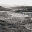
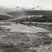
C 4742 |
|
General view of site from North |
27/1/1993 |
Item Level |
|
|
Photographs and Off-line Digital Images |
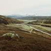
C 4743 CN |
|
Distant view of site from North |
27/1/1993 |
Item Level |
|
|
Photographs and Off-line Digital Images |
C 4743 |
|
Distant view of site from North |
27/1/1993 |
Item Level |
|
|
Photographs and Off-line Digital Images |
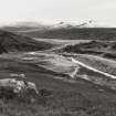
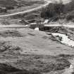
C 4744 CN |
|
View of site from North |
27/1/1993 |
Item Level |
|
|
Photographs and Off-line Digital Images |
C 4744 |
|
View of site from North |
27/1/1993 |
Item Level |
|
|
Photographs and Off-line Digital Images |
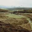
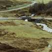
C 4745 CN |
|
View of site from North, showing bridge |
27/1/1993 |
Item Level |
|
|
Photographs and Off-line Digital Images |
C 4745 |
|
View of site from North, showing bridge |
27/1/1993 |
Item Level |
|
|
Photographs and Off-line Digital Images |
B 55790 CN |
|
Drawing of camp |
c. 1860 |
Item Level |
|
 |
On-line Digital Images |
SC 2569948 |
|
General view of site from North |
27/1/1993 |
Item Level |
|
 |
On-line Digital Images |
SC 2569949 |
|
Distant view of site from North |
27/1/1993 |
Item Level |
|
 |
On-line Digital Images |
SC 2569950 |
|
Distant view of site from North |
27/1/1993 |
Item Level |
|
 |
On-line Digital Images |
SC 2569951 |
|
View of site from North |
27/1/1993 |
Item Level |
|
 |
On-line Digital Images |
SC 2569952 |
|
View of site from North |
27/1/1993 |
Item Level |
|
 |
On-line Digital Images |
SC 2569953 |
|
View of site from North, showing bridge |
27/1/1993 |
Item Level |
|
 |
On-line Digital Images |
SC 2569954 |
|
View of site from North, showing bridge |
27/1/1993 |
Item Level |
|
|
All Other |
551 166/1/1 |
Records of the Ordnance Survey, Southampton, Hampshire, England |
Archaeological site card index ('495' cards) |
1947 |
Sub-Group Level |
|


