
Several Hill


Palisaded Enclosure (Later Prehistoric)(Possible), Sunken Floored Building (Medieval)(Possible)
Site Name Several Hill
Classification Palisaded Enclosure (Later Prehistoric)(Possible), Sunken Floored Building (Medieval)(Possible)
Alternative Name(s) East Galdenoch
Canmore ID 78935
Site Number NX15NW 78.03
NGR NX 10814 56087
NGR Description Centre
Datum OSGB36 - NGR
Permalink http://canmore.org.uk/site/78935


- Council Dumfries And Galloway
- Parish Stoneykirk
- Former Region Dumfries And Galloway
- Former District Wigtown
- Former County Wigtownshire
NX15NW 78.03 1081 5607
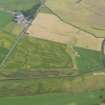
Cropmarks have revealed a palisaded enclosure about 500m to the NE of East Galdenoch amongst other cropmarkings (see NX15NW 78.00). It has an internal diameter of about 25m in places with an entrance in the ESE. The two sides of the entrance curve round into the enclosure and almost hook back on themselves.
Information from RCAHMSAP (RHM) 8 June 1994.
Aerial Photographic Transcription (13 March 1993 - 21 October 1993)
An aerial transcription was produced from oblique aerial photographs. Information from Historic Environment Scotland (BM) 31 March 2017.
Aerial Photographic Transcription (7 December 2011)
Aerial Photographic Interpretation (11 August 2022)
What may be a sunken floored building has been recorded as cropmarking on oblique aerial photographs (RCAHMSAP 1992) about 6m NW of the palisaded enclosure previously described. The feature is visible as a broadly trapezoidal dark mark measuring around 8m from NW to SE by about 4m transversely.
Information from HES Archaeological Survey (K. Millican) 11 August 2022.
Note (23 August 2022)
The location, classification and period of this site have been reviewed and changed from CROPMARK(S) (PERIOD UNKNOWN), PALISADED ENCLOSURE (PERIOD UNASSIGNED).

