
Dunragit


Pit(S) (Period Unknown), Timber Enclosure(S) (Late Neolithic)
Site Name Dunragit
Classification Pit(S) (Period Unknown), Timber Enclosure(S) (Late Neolithic)
Canmore ID 78922
Site Number NX15NW 76.01
NGR NX 14921 57399
NGR Description Centre
Datum OSGB36 - NGR
Permalink http://canmore.org.uk/site/78922


- Council Dumfries And Galloway
- Parish Old Luce
- Former Region Dumfries And Galloway
- Former District Wigtown
- Former County Wigtownshire
NX15NW 76.01 1491 5739
See also NX15NW 76.00 and NX15NE 69.00.
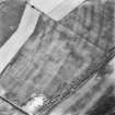
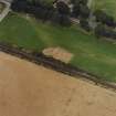
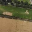
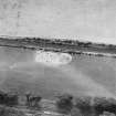
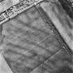
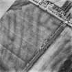
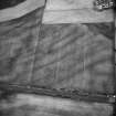
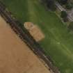
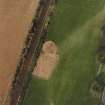
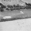
This enclosure, which is defined by two roughly concentric lines of pits, is plotted as a large ritual enclosure on a distribution map of Neolithic monuments covering southern Scotland.
Information from RCAHMS (ARG), 3 April 1998
RCAHMS 1997.
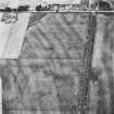
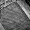
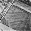
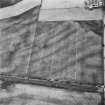
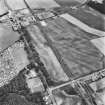
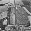
Aerial Photographic Transcription (10 September 1992 - 16 December 1992)
An aerial transcription was produced from oblique aerial photographs. Information from Historic Environment Scotland (BM) 31 March 2017.
Note (11 April 2014)
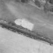
Excavation revealed the postholes of concentric timber enclosures, and as such the classification has been changed from pit enclosures to timber enclosures.
Information from RCAHMS (KMM) 11 April 2014
Aerial Photographic Interpretation (15 December 2021)
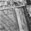
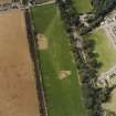
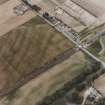
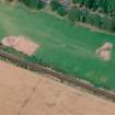
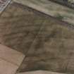
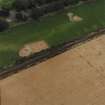
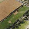
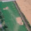
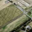
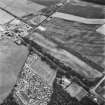
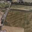
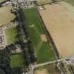
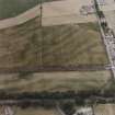
This large timber enclosure, which has been partly excavated and shown to be of late Neolithic date (Thomas 2015), is situated on level ground at the foot of Challoch Hill. It has been recorded as cropmarking on oblique aerial photographs (RCAHMSAP 1992) and comprises three concentric rings of postholes forming a subcircular enclosure measuring about 290m in overall diameter. The outer ring of postholes (NX15NW 76.2) is irregular in form with distinct in-turns on its S side that lend it a scalloped appearance. The middle ring (NX15NW 76.1) measures about 130m in diameter and a probable entrance in the form of a double row of postholes with bowed sides extends SSW from it for distance of about 32m. Excavation identified that smaller timbers (interpreted as supports for planking of a continuous fence) were once set between the large postholes of both the outer and central rings. No evidence for similar features was found in association with the inner ring (NX15NW 76.1), which measures about 108m in diameter.
This timber enclosure is associated with a complex of features, including a cursus (NX15NW 76.04), round barrows (NX15NW 76.03 and NX15NE 69.05), a timber circle (NX15NE 69.01), a possible henge (NX15NE 69.03) and a pit-alignment (NX15NE 69.02).
Information from HES Archaeological Survey (K. Millican) 15 December 2021.
Note (24 August 2022)
The location, classification and period of this site have been reviewed and changed from TIMBER ENCLOSURE(S) (NEOLITHIC).

