Accessibility

Font Size

100% 150% 200%

Background Colour

Default Contrast
Close Reset

Pricing Change

New pricing for orders of material from this site will come into place shortly. Charges for supply of digital images, digitisation on demand, prints and licensing will be altered. 


Drumflower

Geological Cropmark(S) (Period Unknown), Pit(S) (Period Unknown)

Site Name Drumflower

Classification Geological Cropmark(S) (Period Unknown), Pit(S) (Period Unknown)

Canmore ID 78917

Site Number NX15NW 74

NGR NX 14305 57685

NGR Description NX 14291 57687 and NX 14345 57680

Datum OSGB36 - NGR

Permalink http://canmore.org.uk/site/78917

Ordnance Survey licence number AC0000807262. All rights reserved.
Canmore Disclaimer. © Bluesky International Limited 2025. Public Sector Viewing Terms

Toggle Aerial | View on large map

Digital Images

Oblique aerial view
Oblique aerial viewOblique aerial view.Oblique aerial view.Oblique aerial view.Oblique aerial view.Oblique aerial photograph of Drumflower taken from the S, centred on the cropmarks of barrows, pits and a pit-alignment with the line of a military road to the N.Oblique aerial photograph of Drumflower taken from the E, centred on the cropmarks of barrows, pits and a pit-alignment with the line of a military road to the N.Oblique aerial view.Oblique aerial view.Oblique aerial view.Oblique aerial view.Oblique aerial view.Oblique aerial view.Oblique aerial view.Oblique aerial photograph of Drumflower taken from the SW, centred on the cropmarks of barrows, pits and a pit-alignment with the line of a military road to the N.Oblique aerial photograph of Drumflower taken from the SE, centred on the cropmarks of barrows, pits and a pit-alignment with the line of a military road to the N.Oblique aerial view.Oblique aerial view

Administrative Areas

  • Council Dumfries And Galloway
  • Parish Old Luce
  • Former Region Dumfries And Galloway
  • Former District Wigtown
  • Former County Wigtownshire

Archaeology Notes

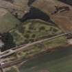
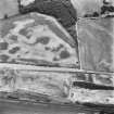
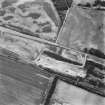
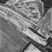
NX15NW 74 centred 14344 57680

Activities

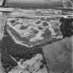
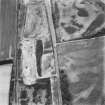
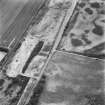
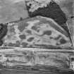
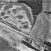
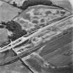
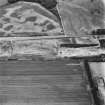
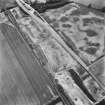
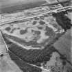
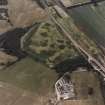
Aerial Photographic Transcription (3 December 1992 - 10 December 1992)

An aerial transcription was produced from oblique aerial photographs. Information from Historic Environment Scotland (BM) 31 March 2017.

Aerial Photographic Interpretation (9 December 2021)

Features recorded as cropmarking on oblique aerial photographs (RCAHMSAP 1992) and previously identified as barrows have been interpreted as geological features. The pit alignment previously recognised could not be identified and has been removed from the classification. A general scattering of pits of unknown date and function has been recorded around the location of these features.

Information from HES Archaeological Survey (K. Millican) 9 December 2021

Note (23 August 2022)

The location, classification and period of this site have been reviewed and changed from BARROW(S) (PREHISTORIC), PIT(S) (PERIOD UNASSIGNED), PIT ALIGNMENT (PREHISTORIC).

References

MyCanmore Image Contributions


Contribute an Image

MyCanmore Text Contributions