
Drumflower


Palisaded Settlement (Later Prehistoric)
Site Name Drumflower
Classification Palisaded Settlement (Later Prehistoric)
Alternative Name(s) Drumflower Bridge
Canmore ID 78914
Site Number NX15NW 25.02
NGR NX 14391 57827
NGR Description Centre
Datum OSGB36 - NGR
Permalink http://canmore.org.uk/site/78914


- Council Dumfries And Galloway
- Parish Old Luce
- Former Region Dumfries And Galloway
- Former District Wigtown
- Former County Wigtownshire
NX15NW 25.02 14391 57827
See also NX15NW 25.00.
Aerial Photographic Transcription (3 December 1992 - 10 December 1992)
An aerial transcription was produced from oblique aerial photographs. Information from Historic Environment Scotland (BM) 31 March 2017.
Aerial Photographic Interpretation (11 November 2021)
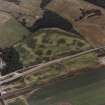
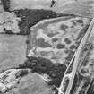
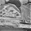
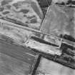
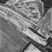
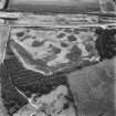
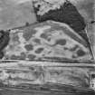
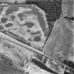
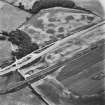
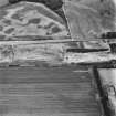
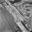
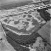
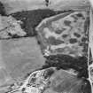
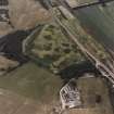
This palisaded settlement is situated on level ground at the foot of Challoch Hill. It has been recorded as cropmarking on oblique aerial photographs (RCAHMSAP 1978; 1992; 1995). It measures about 25m in diameter within two close-set and concentric palisade trenches, the outer being markedly broader than the inner. In the interior a setting of six post-holes imply the presence of a round house measuring 14m-15m in diameter. Other pits have been recorded both within the enclosure and in the area around. A second palisaded settlement (NX15NW 25.01) has been recorded about 30m to the NW.
Information from HES Archaeological Survey (K. Millican) 11 November 2021
Note (7 March 2022)
The location, classification and period of this site have been reviewed and changed from PALISADED ENCLOSURE (PERIOD UNASSIGNED).

