|
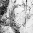
Photographs and Off-line Digital Images |
B 48632 |
RCAHMS Aerial Photography |
Oblique aerial view. |
1991 |
Item Level |
|
|
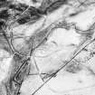
Photographs and Off-line Digital Images |
B 48633 |
RCAHMS Aerial Photography |
Oblique aerial view. |
1991 |
Item Level |
|
|
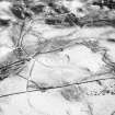
Photographs and Off-line Digital Images |
B 48634 |
RCAHMS Aerial Photography |
Oblique aerial view. |
1991 |
Item Level |
|
|
Photographs and Off-line Digital Images |
B 48635 |
RCAHMS Aerial Photography |
Oblique aerial view. |
1991 |
Item Level |
|
|
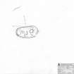
Prints and Drawings |
DC 32414 |
Records of the Royal Commission on the Ancient and Historical Monuments of Scotland (RCAHMS), Edinbu |
Survey drawing; Plan of Park Hill scooped settlement, indicating modern track. |
23/9/1991 |
Item Level |
|
|
Prints and Drawings |
DC 32581 |
Records of the Royal Commission on the Ancient and Historical Monuments of Scotland (RCAHMS), Edinbu |
Publication drawing; Plan of Park Hill (Hillhead) scooped settlement and enclosure. |
4/1994 |
Item Level |
|
|
Prints and Drawings |
DC 32163 |
Records of the Royal Commission on the Ancient and Historical Monuments of Scotland (RCAHMS), Edinbu |
Comparative plans of scooped settlements at Floshlands Wood, Beattock Hill, Mollin, Stidriggs and Park Hill: publication drawing for Inventory of Eastern Dumfriesshire. Unattributed, [1996]. |
1996 |
Item Level |
|
 |
On-line Digital Images |
SC 381974 |
Records of the Royal Commission on the Ancient and Historical Monuments of Scotland (RCAHMS), Edinbu |
Publication drawing; Plan of Park Hill (Hillhead) scooped settlement and enclosure. |
4/1994 |
Item Level |
|
 |
On-line Digital Images |
SC 393338 |
|
CROPPED IMAGE |
|
Item Level |
|
 |
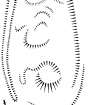
On-line Digital Images |
SC 1351815 |
Records of the Royal Commission on the Ancient and Historical Monuments of Scotland (RCAHMS), Edinbu |
Survey drawing; Plan of Park Hill scooped settlement |
23/9/1991 |
Item Level |
|
 |
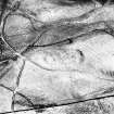
On-line Digital Images |
SC 1759728 |
RCAHMS Aerial Photography |
Oblique aerial view. |
1991 |
Item Level |
|
 |
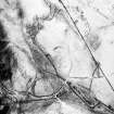
On-line Digital Images |
SC 1759729 |
RCAHMS Aerial Photography |
Oblique aerial view. |
1991 |
Item Level |
|
 |
On-line Digital Images |
SC 1759730 |
RCAHMS Aerial Photography |
Oblique aerial view. |
1991 |
Item Level |
|
 |
On-line Digital Images |
SC 1759731 |
RCAHMS Aerial Photography |
Oblique aerial view. |
1991 |
Item Level |
|
|
Digital Files (Non-image) |
TM 001102 |
Records of the Royal Commission on the Ancient and Historical Monuments of Scotland (RCAHMS), Edinbu |
Survey data relating to the RCAHMS survey of Eastern Dumfriesshire. Includes dxf files for each 10000 map sheet, combined linework file (.dxf) and survey linework metadata form. |
1990 |
Item Level |
|
|
Digital Files (Non-image) |
TM 002340 |
Records of the Royal Commission on the Ancient and Historical Monuments of Scotland (RCAHMS), Edinbu |
Survey data relating to the RCAHMS survey of Eastern Dumfriesshire. Includes shapefile, geojson and metadata form. |
1990 |
Item Level |
|


