
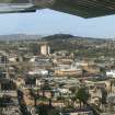
Dundee, Law Hill, War Memorial


War Memorial (20th Century)
Site Name Dundee, Law Hill, War Memorial
Classification War Memorial (20th Century)
Canmore ID 78707
Site Number NO33SE 32.01
NGR NO 39145 31285
Datum OSGB36 - NGR
Permalink http://canmore.org.uk/site/78707


- Council Dundee, City Of
- Parish Dundee (Dundee, City Of)
- Former Region Tayside
- Former District City Of Dundee
- Former County Angus
NO33SE 32.01 39145 31285
Incident (1923)
The fort occupying the summit of Dundee Law was badly disturbed during the construction of the war memorial (NO33SE 32.01) in 1923, when the S end was completely destroyed.
Coutts, 1970

