
Bute, Quien


Cultivation Remains (Period Unassigned), Farmstead (Period Unassigned), Horse Engine Platform(S) (Post Medieval)
Site Name Bute, Quien
Classification Cultivation Remains (Period Unassigned), Farmstead (Period Unassigned), Horse Engine Platform(S) (Post Medieval)
Canmore ID 78627
Site Number NS05NE 35
NGR NS 05803 59094
Datum OSGB36 - NGR
Permalink http://canmore.org.uk/site/78627


- Council Argyll And Bute
- Parish North Bute
- Former Region Strathclyde
- Former District Argyll And Bute
- Former County Buteshire
NS05NE 35 05803 59094.
Recorded during survey of deserted settlements; records are held in the Bute Museum.
Sponsor: Bute Antiq Natur Hist Soc; St Andrews Heritage Services.
Hannah and Proudfoot 1994.
A farmstead, comprising one unroofed building within an enclosure is depicted on the 1st edition of the OS 6-inch map (Argyllshire and Buteshire 1869, sheet ccxv), but it is not shown on the current edition of the OS 1:10000 map (1980).
Information from RCAHMS (AKK) 15 October 1998.
NS 058 591 Site 85 Quien
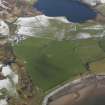
This farm, in record from 1440, was abandoned early in the 20th century and now, partially restored, serves as a kennels, the land being farmed from Scalpsie. The standing buildings date from the mid 19th century and include the well-preserved stance of a circular ‘rink’ mill. Aerial photo in TBNHS Vol XXIV (1996) p40.
Proudfoot and Hannah 2000
NS 0580 5910 Farm ruins: Located 150m NE of Scalpsie farm (NS05NE 110). Partially restored ruins of the farm are now used as kennels. Old platform and foundations of structure 50m SW of farm. Stone lined well in close proximity to farmhouse. Farm documented since 1440.
Information from Bute Natural History Society Deserted Settlement Survey (1991-9)
(RCAHMS WP000273)
Quien is no longer a working farmsteading and its buildings, including modern kennels, are now used by Scalpsie Farm (NS05NE 110). Except for the roofless farmhouse at the NE end of the steading, all of the buildings are roofed and in good repair. Each of the two barns has a horse-engine platform attached to its SW side.
The farmstead is depicted on two 18th century estate maps. Foulis (1758-9, RHP 14107/42) shows four buildings and two enclosures depicted here and the surrounding ground is depicted as cultivated and annotated 'fine light arable crofts'. May (1781) shows four buildings and three enclosures surrounded by cultivated fields. The steading is depicted roofed on the 1st edition of the OS 6-inch map (Buteshire 1869, sheet CCXV), but the horse-engine platforms appear only on the later 2nd edition of the map (Buteshire 1897, sheet CCXV).
Visited by RCAHMS (AGCH, LAD) 3 April 2009.
Antiquarian Mapping (1758 - 1759)
Antiquarian Mapping (1781)
Reference (1782)
Field Visit (1863)
Field Visit (1991 - 1999)
Recorded during survey of deserted settlements; records are held in the Bute Museum.
Sponsor: Bute Antiq Natur Hist Soc; St Andrews Heritage Services.
Hannah and Proudfoot 1994.
NS 058 591 Site 85 Quien
This farm, in record from 1440, was abandoned early in the 20th century and now, partially restored, serves as a kennels, the land being farmed from Scalpsie. The standing buildings date from the mid 19th century and include the well-preserved stance of a circular ‘rink’ mill. Aerial photo in TBNHS Vol XXIV (1996) p40.
Proudfoot and Hannah 2000
NS 0580 5910 Farm ruins: Located 150m NE of Scalpsie farm. Partially restored ruins of the farm are now used as kennels. Old platform and foundations of structure 50m SW of farm. Stone lined well in close proximity to farmhouse. Farm documented since 1440.
Information from Bute Natural History Society Deserted Settlement Survey (1991-9)
(RCAHMS WP000273)
Desk Based Assessment (15 October 1998)
A farmstead, comprising one unroofed building within an enclosure is depicted on the 1st edition of the OS 6-inch map (Argyllshire and Buteshire 1869, sheet ccxv), but it is not shown on the current edition of the OS 1:10000 map (1980).
Information from RCAHMS (AKK) 15 October 1998.
Field Visit (3 April 2009)
Quien is no longer a working farmsteading and its buildings, including modern kennels, are now used by Scalpsie Farm (NS05NE 110). Except for the roofless farmhouse at the NE end of the steading, all of the buildings are roofed and in good repair. Each of the two barns has a horse-engine platform attached to its SW side.
The farmstead is depicted on two 18th century estate maps. Foulis (1758-9, RHP 14107/42) shows four buildings and two enclosures depicted here and the surrounding ground is depicted as cultivated and annotated 'fine light arable crofts'. May (1781) shows four buildings and three enclosures surrounded by cultivated fields. The steading is depicted roofed on the 1st edition of the OS 6-inch map (Buteshire 1869, sheet CCXV), but the horse-engine platforms appear only on the later 2nd edition of the map (Buteshire 1897, sheet CCXV).
Visited by RCAHMS (AGCH, LAD) 3 April 2009.
Standing Building Recording (1 July 2015 - 31 May 2016)
A suite of archaeological work was carried out at Quien Farm, North Bute, Isle of Bute between July 2015 and May 2016 in response to a planning condition placed on planning consent by Argyll and Bute Council, following advice from West of Scotland Archaeology Services. The work initially comprised a desk-based study and photographic survey. This was followed by archaeological monitoring of ground breaking works during construction. Two discreet areas of surviving (probable) 19th century cobbling relating to the upstanding farm buildings were recorded. Nothing else of archaeological significance was observed.
Information from Paul R j Duffy (Brandanii Archaeology and Heritage) May 2016. OASIS ID - brandani1-346261

