
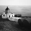
St Abb's Head Lighthouse


Lighthouse (19th Century)
Site Name St Abb's Head Lighthouse
Classification Lighthouse (19th Century)
Alternative Name(s) Firth Of Forth; North Sea
Canmore ID 78115
Site Number NT96NW 39
NGR NT 91425 69243
Datum OSGB36 - NGR
Permalink http://canmore.org.uk/site/78115


- Council Scottish Borders, The
- Parish Coldingham
- Former Region Borders
- Former District Berwickshire
- Former County Berwickshire
NT96NW 39.00 91425 69243
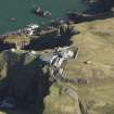
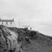
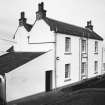
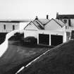
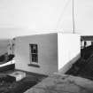
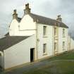
NT96NW 39.01 91376 69213 Lightkeeper's Cottage
NT96NW 39.02 91389 69289 Lighthouse Retreat and Keeper's Hold
NT96NW 39.03 91337 69226 Boundary Walls and Gate Piers
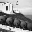
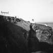
NT96NW 39.04 91448 69268 Foghorn
NT96NW 39.05 91387 69226 Foghorn Engine House
NT96NW 39.06 91397 69211 Stair and Wall
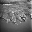
For (associated) Pettico Wick Harbour (NT 9080 6907), see NT96NW 47.
See also:
NT96NW 49 91294 69046 St Abb's Head, Walled Garden
L Ho [NAT]
OS 1:10,000 map, 1976.
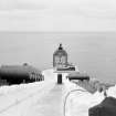
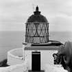
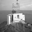
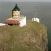
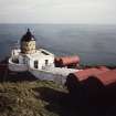
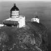
This lighthouse was established in 1862, the engineers being David and Thomas Stevenson. In 1876, it was the location of the first fog signal (of American design) to be installed in Scotland. It was electrified in 1968, the light having a maximum intensity of 3 million candlepower. A high power Racon beacon was installed in the same year, but was subsequently replaced by a low-power self-operating type. The lighthouse also became the radio reporting station for the lighthouses in the Forth estuary.
R W Munro 1979.
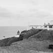
Erected in 1862. There is a fog horn on the edge of the promontory.
Site recorded by GUARD during the Coastal Assessment Survey for Historic Scotland, 'The Firth of Forth from Dunbar to the Coast of Fife' 10th March 1996.
NT 87 70 to NT 91 67 An archaeological survey was undertaken by Headland Archaeology Ltd of land owned by the National Trust for Scotland at St Abb's Head, Lumsdaine Shore and Blackpotts.
A total of 18 features, or groups of features, of archaeological and historical interest were recorded, ten already documented, at least in part, in NMRS records.
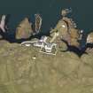
NT 9141 6922 Lighthouse and keeper's houses (NT96NW 39; 39.01)
Sponsors: Historic Scotland, National Trust for Scotland
S Carter 1997.
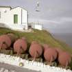
NT 9141 6922 As part of the survey conducted by Headland Archaeology Ltd on behalf of the National Trust for Scotland on its land at and near St Abb's Head, mentioned above (S Carter 1997), this site was examined and recorded. The report states that St Abb's Head lighthouse was constructed in 1862, and that the buildings are in current use and are well maintained.
Sponsors: National Trust for Scotland, Historic Scotland
NMRS MS/899/44 (Headland Archaeology Ltd 16/10/1997).
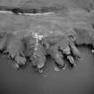
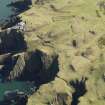
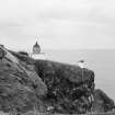
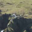
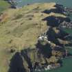
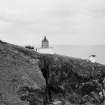
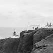
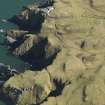
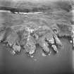
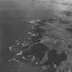
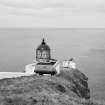
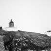
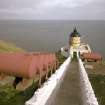
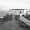
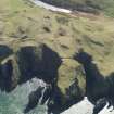
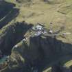
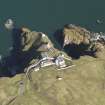
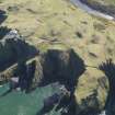
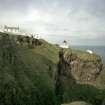
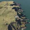
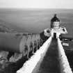
This shore lighthouse is situated on the edge of a cliff at the southernmost point of entry to the Firth of Forth.
Information from RCAHMS (RJCM), 2 February 2006.
Construction (1862)
This lighthouse was established in 1862, the engineers being David and Thomas Stevenson. In 1876, it was the location of the first fog signal (of American design) to be installed in Scotland. It was electrified in 1968, the light having a maximum intensity of 3 million candlepower. A high power Racon beacon was installed in the same year, but was subsequently replaced by a low-power self-operating type. The lighthouse also became the radio reporting station for the lighthouses in the Forth estuary.
R W Munro 1979.
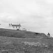
Photographic Survey (September 1961)
Survey of St Abbs harbour and lighthouse, Berwickshire, by the Scottish National Buildings Record in 1961.
Field Visit (10 March 1996)
Erected in 1862. There is a fog horn on the edge of the promontory.
Site recorded by GUARD during the Coastal Assessment Survey for Historic Scotland, 'The Firth of Forth from Dunbar to the Coast of Fife' 10th March 1996.
Field Visit (16 October 1997)
NT 9141 6922 As part of the survey conducted by Headland Archaeology Ltd on behalf of the National Trust for Scotland on its land at and near St Abb's Head, (S Carter 1997), this site was examined and recorded. The report states that St Abb's Head lighthouse was constructed in 1862, and that the buildings are in current use and are well maintained.
Sponsors: National Trust for Scotland, Historic Scotland
NMRS MS/899/44 (Headland Archaeology Ltd 16/10/1997).
Note (2 February 2006)
This shore lighthouse is situated on the edge of a cliff at the southernmost point of entry to the Firth of Forth.
Information from RCAHMS (RJCM), 2 February 2006.
Project (2007)
This project was undertaken to input site information listed in 'Civil engineering heritage: Scotland - Lowlands and Borders' by R Paxton and J Shipway, 2007.
Publication Account (2007)
A major light and fog horn, with a tower only 29 ft high but, being on the headland, its light is about 223 ft abovesea level giving a range of 29 miles. When operating, the 3 000 000 candlepower light flashes white every ten seconds.
The station was erected in 1862 under the direction of Northern Lighthouse Board engineers D. & T. Stevenson.
The inclined astragals in the lantern glazing, to minimise interference with the light beam, were a feature first introduced by Alan Stevenson about two decades earlier. The first Scottish lighthouse foghorn was introduced here in 1876. It is no longer operational.
R Paxton and J Shipway 2007
Reproduced from 'Civil Engineering heritage: Scotland - Lowlands and Borders' with kind permission of Thomas Telford Publishers.
R Paxton and J Shipway 2007
Sbc Note
Visibility: This is an upstanding building.
Information from Scottish Borders Council.

