
Lentran Point


Fish Trap (Period Unassigned)
Site Name Lentran Point
Classification Fish Trap (Period Unassigned)
Alternative Name(s) Beauly Firth
Canmore ID 77994
Site Number NH54NE 29
NGR NH 5840 4620
Datum OSGB36 - NGR
Permalink http://canmore.org.uk/site/77994


- Council Highland
- Parish Kirkhill
- Former Region Highland
- Former District Inverness
- Former County Inverness-shire
NH54NE 29 5840 4620
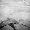
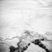
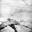
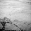
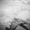
Aerial photographs show the remains of tidal-covered walling 400m long with a curving return arm 150m long, almost certainly a tidal fish-trap.
J Wordsworth 1992.
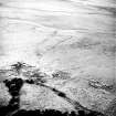
(NH 5841 4622) Fish trap - linear. Under threat of tidal erosion.
CFA/MORA Coastal Assessment Survey 1998.
Aerial Photographic Interpretation (1992)
Aerial photographs show the remains of tidal-covered walling 400m long with a curving return arm 150m long, almost certainly a tidal fish-trap.
J Wordsworth 1992.
Ground Survey (1998)
(NH 5841 4622) Fish trap - linear. Under threat of tidal erosion.
CFA/MORA Coastal Assessment Survey 1998.

