|
Manuscripts |
MS 726/167 |
Records of CFA Archaeology Ltd, archaeologists, Musselburgh, East Lothian, Scotland |
Coastal Assessment Survey: Inner Moray Firth, Volumes 1 and 2. |
14/12/1998 |
Item Level |
|
|
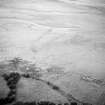
Photographs and Off-line Digital Images |
E 06720 |
RCAHMS Aerial Photography |
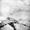
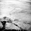
Oblique aerial view centred on the remains of the fish trap, taken from the SSE. |
18/7/2001 |
Item Level |
|
|
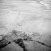
Photographs and Off-line Digital Images |
E 06721 |
RCAHMS Aerial Photography |
Oblique aerial view centred on the remains of the fish trap, taken from the S. |
18/7/2001 |
Item Level |
|
|
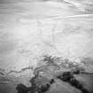
Photographs and Off-line Digital Images |
E 06722 |
RCAHMS Aerial Photography |
Oblique aerial view centred on the remains of the fish trap, taken from the SE. |
18/7/2001 |
Item Level |
|
|
Manuscripts |
MS 2776/1/1 |
Historic Scotland Archive Project |
Survey archive: Site record sheets, site record sheets with field notes and monument forms from the Inner Moray Firth (Moray, Beauly and Cromarty Firth) Coastal Assessment Survey. Sheet 1. |
9/1998 |
Item Level |
|
|
Prints and Drawings |
BD 104/1/1 |
Historic Scotland Archive Project |
Survey archive: 1:25,000 OS Pathfinder map depicting site locations from the Moray, Beauly and Cromarty Firth Coastal Assessment Survey, Sheet 1. |
9/1998 |
Item Level |
|
 |
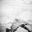
On-line Digital Images |
SC 1155620 |
RCAHMS Aerial Photography |
Oblique aerial view centred on the remains of the fish trap, taken from the SE. |
18/7/2001 |
Item Level |
|
 |
On-line Digital Images |
SC 1155634 |
RCAHMS Aerial Photography |
Oblique aerial view centred on the remains of the fish trap, taken from the S. |
18/7/2001 |
Item Level |
|
 |
On-line Digital Images |
SC 1155635 |
RCAHMS Aerial Photography |
Oblique aerial view centred on the remains of the fish trap, taken from the SSE. |
18/7/2001 |
Item Level |
|
 |
On-line Digital Images |
SC 1695276 |
RCAHMS Aerial Photography |
Oblique aerial view centred on the remains of the fish trap, taken from the SSE. |
18/7/2001 |
Item Level |
|
 |
On-line Digital Images |
SC 1695277 |
RCAHMS Aerial Photography |
Oblique aerial view centred on the remains of the fish trap, taken from the S. |
18/7/2001 |
Item Level |
|
 |
On-line Digital Images |
SC 1695278 |
RCAHMS Aerial Photography |
Oblique aerial view centred on the remains of the fish trap, taken from the SE. |
18/7/2001 |
Item Level |
|
|
Photographs and Off-line Digital Images |
BS 97/1 CS |
Historic Scotland Archive Project |
Survey photographs: From the Moray, Beauly and Cromarty Firth Coastal Assessment Survey - Caledonian Canal basin; Lentran point; Balintore canal; Balcarse; Easter Lovat; Beauly reedbeds; Spital shore; Milton and Redcastle to Corgrain point. |
1998 |
Batch Level |
|


