
Following the launch of trove.scot in February 2025 we are now planning the retiral of some of our webservices. Canmore will be switched off on 24th June 2025. Information about the closure can be found on the HES website: Retiral of HES web services | Historic Environment Scotland
Kilrenny, General


Burgh (Medieval), Village (Period Unassigned)
Site Name Kilrenny, General
Classification Burgh (Medieval), Village (Period Unassigned)
Canmore ID 77562
Site Number NO50SE 57
NGR NO 574 048
Datum OSGB36 - NGR
Permalink http://canmore.org.uk/site/77562


- Council Fife
- Parish Kilrenny
- Former Region Fife
- Former District North East Fife
- Former County Fife
NO50SE 57 57 04.
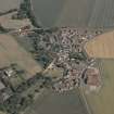
Kilrenny: a burgh of regality chartered in 1578; enrolled (apparently in error) as a royal burgh in 1592, and continued to possess that status.
G S Pryde 1965.
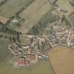
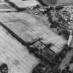
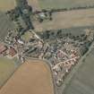
NO 575 048 A programme of topographic survey, geophysical survey and fieldwalking took place in October to examine the possibility that a monastic precinct outer ditch or vallum survived around the village of Kilrenny, as previously proposed (PSAS 1998, 495-514).
The geophysical results have still to be fully analysed, but while there is clearly rig and furrow, old field boundaries and structures which may be of medieval date, there seems to be no unequivocal evidence for a ditch. The fieldwalking produced an assemblage of medieval pottery and later material from a field to the N of the village, at NO 575 050.
A report will be lodged with the NMRS.
Sponsors: Society of Antiquaries of Scotland, Russell Trust.
H F James 2000
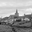
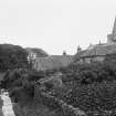
Photographic Survey (July 1963)
Photographic survey of buildings in Kilrenny, Fife, by the Scottish National Buildings Record/Ministry of Work in July 1963.

