
Pricing Change
New pricing for orders of material from this site will come into place shortly. Charges for supply of digital images, digitisation on demand, prints and licensing will be altered.
Shurrery Kirk


Standing Stone(S) (Prehistoric), Stone Circle (Neolithic) - (Bronze Age)(Possible)
Site Name Shurrery Kirk
Classification Standing Stone(S) (Prehistoric), Stone Circle (Neolithic) - (Bronze Age)(Possible)
Canmore ID 7695
Site Number ND05NW 10
NGR ND 0488 5858
NGR Description ND 0488 5858 and ND 0489 5858
Datum OSGB36 - NGR
Permalink http://canmore.org.uk/site/7695


- Council Highland
- Parish Reay
- Former Region Highland
- Former District Caithness
- Former County Caithness
ND05NW 10 0488 5858 and 0489 5858.
(ND 0488 5858; ND 0489 5858) Standing Stones (NR)
OS 6" map, (1963)
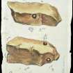
These two stones, from their relationship, may have stood on the circumference of a stone circle. Both stones are upright and pointed, the eastern measuring 3ft 6ins by 1ft at base and 2ft 2ins high, and the other, 3ft 2ins by 1ft at base and 2ft high. The area of the circle has been disturbed by peat digging.
RCAHMS 1911.
These two slab-like stones are as described by the RCAHMS.
Surveyed at 1:2500.
Visited by OS (R D) 17 November 1964.
A possible stone circle.
A Burl 1976.
These two standing stones, forming the remains of a possible stone circle are as described.
Visited by OS (J B) 21 July 1981.

