
Following the launch of trove.scot in February 2025 we are now planning the retiral of some of our webservices. Canmore will be switched off on 24th June 2025. Information about the closure can be found on the HES website: Retiral of HES web services | Historic Environment Scotland
Littlemill


Ring Ditch(S) (Period Unassigned), Unenclosed Settlement (Period Unassigned)
Site Name Littlemill
Classification Ring Ditch(S) (Period Unassigned), Unenclosed Settlement (Period Unassigned)
Alternative Name(s) Cotetown; Johnston
Canmore ID 76929
Site Number NJ52SE 29
NGR NJ 58423 24862
NGR Description Centred NJ 58423 24862
Datum OSGB36 - NGR
Permalink http://canmore.org.uk/site/76929


- Council Aberdeenshire
- Parish Leslie (Gordon)
- Former Region Grampian
- Former District Gordon
- Former County Aberdeenshire
NJ52SE 29 centred 58423 24862
Formerly entered at cited location NJ 583 248.
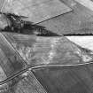
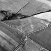
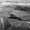
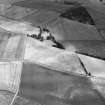
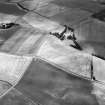
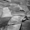
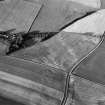
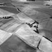
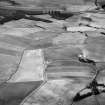
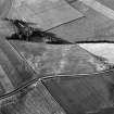
(Location cited as NJ 584 249 and name as Cotetown). Air photography (AAS/83/11/R28/2-6 and AAS/83/14/R31/5-8) has recorded the cropmarks of about ten ring-ditches, which may represent houses, at an altitude of 190m OD.
NMRS, MS/712/53.
Scheduled as 'Johnston, unenclosed settlement... an unenclosed settlement of prehistoric date, visible as cropmarks on oblique air photographs.' It is situated in gently sloping ground in a cultivated field, 195-200m ababove sea level.
(Location revised on evidence of map attached to scheduling document).
Information from Historic Scotland, scheduling document dated 1 March 2007.

