|
Photographs and Off-line Digital Images |
B 92092 PO |
Records of Aberdeen Aerial Surveys, Aberdeen, Scotland |
Aerial photograph |
1983 |
Item Level |
|
|
Manuscripts |
MS 712/53 |
Records of Aberdeenshire Archaeology Service, Aberdeen, Scotland |
Photocopies of Aberdeenshire Archaeological Service site record sheets for map sheets NJ52SW and NJ52SE, received 5 March 1999. |
1999 |
Item Level |
|
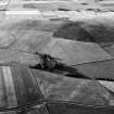 |
On-line Digital Images |
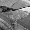
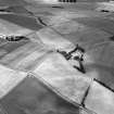
SC 1005246 |
Records of Aberdeen Aerial Surveys, Aberdeen, Scotland |
Oblique aerial view centred on the cropmarks of the unenclosed settlement and ring ditches at Littlemill with the farmstead at Cotetown adjacent, looking to the NE. |
27/7/1983 |
Item Level |
|
 |
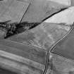
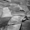
On-line Digital Images |
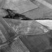
SC 1005247 |
Records of Aberdeen Aerial Surveys, Aberdeen, Scotland |
Oblique aerial view centred on the cropmarks of the unenclosed settlement and ring ditches at Littlemill with the farmstead at Cotetown adjacent, looking to the SW. |
27/7/1983 |
Item Level |
|
 |
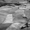
On-line Digital Images |
SC 1005248 |
Records of Aberdeen Aerial Surveys, Aberdeen, Scotland |
Oblique aerial view centred on the cropmarks of the unenclosed settlement and ring ditches at Littlemill with the farmstead at Cotetown adjacent, looking to the SW. |
27/7/1983 |
Item Level |
|
 |
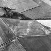
On-line Digital Images |
SC 1005249 |
Records of Aberdeen Aerial Surveys, Aberdeen, Scotland |
Oblique aerial view centred on the cropmarks of the unenclosed settlement and ring ditches at Littlemill with the farmstead at Cotetown adjacent, looking to the ENE. |
27/7/1983 |
Item Level |
|
 |
On-line Digital Images |
SC 1005250 |
Records of Aberdeen Aerial Surveys, Aberdeen, Scotland |
Oblique aerial view centred on the cropmarks of the unenclosed settlement and ring ditches at Littlemill with the farmstead at Cotetown adjacent, looking to the NE. |
27/7/1983 |
Item Level |
|
 |
On-line Digital Images |
SC 1005251 |
Records of Aberdeen Aerial Surveys, Aberdeen, Scotland |
Oblique aerial view centred on the cropmarks of the unenclosed settlement and ring ditches at Littlemill with the farmstead at Cotetown adjacent, looking to the NNE. |
27/7/1983 |
Item Level |
|
 |
On-line Digital Images |
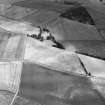
SC 1005337 |
Records of Aberdeen Aerial Surveys, Aberdeen, Scotland |
Oblique aerial view centred on the cropmarks of the unenclosed settlement and ring ditches at Littlemill and Cotetown, looking to the N. |
6/8/1983 |
Item Level |
|
 |
On-line Digital Images |
SC 1005338 |
Records of Aberdeen Aerial Surveys, Aberdeen, Scotland |
Oblique aerial view centred on the cropmarks of the unenclosed settlement and ring ditches at Littlemill and Cotetown, looking to the NNW. |
6/8/1983 |
Item Level |
|
 |
On-line Digital Images |
SC 1005339 |
Records of Aberdeen Aerial Surveys, Aberdeen, Scotland |
Oblique aerial view centred on the cropmarks of the unenclosed settlement and ring ditches at Littlemill and Cotetown, looking to the NNW. |
6/8/1983 |
Item Level |
|
 |
On-line Digital Images |
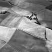
SC 1005340 |
Records of Aberdeen Aerial Surveys, Aberdeen, Scotland |
Oblique aerial view centred on the cropmarks of the unenclosed settlement and ring ditches at Littlemill and Cotetown, looking to the W. |
6/8/1983 |
Item Level |
|
 |
On-line Digital Images |
SC 1005341 |
Records of Aberdeen Aerial Surveys, Aberdeen, Scotland |
Oblique aerial view centred on the cropmarks of the unenclosed settlement and ring ditches at Littlemill and Cotetown, looking to the WNW. |
6/8/1983 |
Item Level |
|
 |
On-line Digital Images |
SC 1937768 |
Records of Aberdeen Aerial Surveys, Aberdeen, Scotland |
Aerial photograph |
1983 |
Item Level |
|


