
Pricing Change
New pricing for orders of material from this site will come into place shortly. Charges for supply of digital images, digitisation on demand, prints and licensing will be altered.
Muirkirk


Mine Workings (Post Medieval)
Site Name Muirkirk
Classification Mine Workings (Post Medieval)
Canmore ID 76376
Site Number NS72NW 11
NGR NS 7020 2621
NGR Description Centred NS 7020 2621
Datum OSGB36 - NGR
Permalink http://canmore.org.uk/site/76376


- Council East Ayrshire
- Parish Muirkirk
- Former Region Strathclyde
- Former District Cumnock And Doon Valley
- Former County Ayrshire
Field Visit (February 1991 - November 1991)
NS72NW 11.00 7020 2621 (centred).
NS72NW 11.01 NS 7020 2621 Mine: Shafts; Horse-engine platforms
NS72NW 11.02 NS 6960 2641 Miners' Cottages
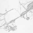
Ironstone, coal and limestone have all been extracted from the area of moorland which lies to the SE of the site of the Ironworks (NS62NE 17). Almost 1.5 sq km in extent, the area is broadly defined by the Linky Burn in the W, and by the Auldhouse Burn in the E. Within this area, the impact of the industrial development wrought by the Ironworks is plain to see. The remains of the mines (NS72NW 11.01) and quarries are interwoven in a web of successive transport systems which ultimately brought the raw materials to the furnaces. The stone footings of the cottages which once housed the miners still remain at Catchyburn, although much of the accommodation, built to house the expanding mining community in Muirkirk in the 19th century, has now been demolished (NS72NW 11.02). Other noteworthy features in the area include the extensive plots of rig and furrow cultivation, and the remains of the lades which provided water for the Ironworks.
Visited by RCAHMS (ARW, SPH), February-November 1991.
T Findlay 1986; J R Hume and J Butt 1966; T McKerrell and J Brown 1979. NMRS MS 731/6

