
Pricing Change
New pricing for orders of material from this site will come into place shortly. Charges for supply of digital images, digitisation on demand, prints and licensing will be altered.
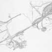
Muirkirk


Lade (Post Medieval)
Site Name Muirkirk
Classification Lade (Post Medieval)
Alternative Name(s) The Great Lade
Canmore ID 76359
Site Number NS62NE 33
NGR NS 6980 2673
NGR Description NS 6980 2673 (N end) - NS 7013 2440 (S end)
Datum OSGB36 - NGR
Permalink http://canmore.org.uk/site/76359

- Council East Ayrshire
- Parish Muirkirk
- Former Region Strathclyde
- Former District Cumnock And Doon Valley
- Former County Ayrshire
Field Visit (February 1991 - November 1991)
NS62NE 33 6980 2673.
The remains of this lade extend for a distance of about 2.5km, running N from the Garpel Water, around the foot of Cairn Table and into the area where the Ironworks (NS62NE 17) once stood. Fed from a sluice on the Garpel water, the lade provided the power to drain the coal-pits near the Ironworks, and offered an additional source of water-power for the Ironworks itself. The Ironworks were demolished in the late 1960's and nothing is now visible in this area, but both the 1st and 2nd eds of the OS 25-inch map (Ayrshire, Sheet xxxi.5, 1856 {survey date} and 1896) show the lade running as far N as the canal basin (NS72NW 7). To the S of the Ironworks, the course of the lade can still be followed, and at several points there is evidence for its refurbishment and modification. About 400m to the SE of the Tarworks (NS62NE 16.00), for instance, a pipeline has been inserted, while immediately to the N, the lade was carried across an area of bog by a series of timber troughs, the remains of which can still be seen; previously, the lade had been routed around the wet ground. There is also evidence that the lade has been re-aligned around areas of limestone and coal workings at the head of the Linky Burn. The spoil dumps from the southernmost limestone quarry overlie the earlier line (NS 7007 2593), and the water was re-directed down the gully of the burn. To the N, at two places on the burn, water has been led off along shorter lades (NS 6979 2641 and NS 6989 2621), and in one case the position of the sluice can still be seen (NS 6989 2621). From here, the lade supplied water to a reservoir (NS 6984 2652) which is depicted on the 2nd ed OS map; now situated in an improved field, the reservoir has been breached and the spread remains of the dam survive only on the SW side (See also NS72NW 11.00).
Visited by RCAHMS (ARW, SPH), February-November 1991.
T Finlay 1986; J R Hume 1969.

