
Following the launch of trove.scot in February 2025 we are now planning the retiral of some of our webservices. Canmore will be switched off on 24th June 2025. Information about the closure can be found on the HES website: Retiral of HES web services | Historic Environment Scotland
Cnoc An Ratha


Enclosure (Period Unassigned), Fort (Period Unassigned), Hut Circle (Prehistoric)
Site Name Cnoc An Ratha
Classification Enclosure (Period Unassigned), Fort (Period Unassigned), Hut Circle (Prehistoric)
Alternative Name(s) Shurrery
Canmore ID 7634
Site Number ND05NE 2
NGR ND 052 577
Datum OSGB36 - NGR
Permalink http://canmore.org.uk/site/7634


- Council Highland
- Parish Reay
- Former Region Highland
- Former District Caithness
- Former County Caithness
ND05NE 2.00 052 577
ND05NE 2.01 0522 5773 Cairn (Possible)
(ND 0528 5770) Supposed Remains of (NAT) Fort (NR)
OS 6" map, Caithness, 2nd ed., (1907)
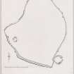
A fort occupies the N end of an eminence rising from the moor of Brawlbin, about 3/4 mile SSE of Shurrery church. It is an irregular oval on plan (q.v.), following the contour of the hill, except on the SW where a straight base crosses the ridge from side to side. It measures some 340ft N-S by a maximum of 300ft transversely within a stone wall some 6 to 7ft in thickness and 2ft high externally. An angle in the wall on the W suggests the position of an entrance, and a large slab protruding across the wall in the NE may indicate the position of another. The main entrance, however, appears to have been from the SE, immediately S of a large circular enclosure which abuts on the outer wall towards the S end of the E side. This entrance appears to have been 4 ft in width. The circular enclosure is entered from the E and measures 27ft by 32ft within a ruinous stone wall some 7 1/2ft thick. The interior of this enclosure has been excavated to a depth of several feet at the back so as to bring the floor to the level of the entrance on the lower slope of the hill.
RCAHMS 1911, visited 1910.
This site has been adequately described by the RCAHMS. For most of its circuit the wall appears as a revetment against the scarp of the summit, although on the W side it appears as a rubble mass 0.3m high and about 1.6m thick. The scooped hut abutting on the SE side is apparently an integral part of the enclosure, as is probably the 'bee- hive' structure noted on ND05NE 2.1. The enclosure is not suggestive of a fortification but rather a settlement of uncertain period.
Visited by OS (J L D) 10 April 1962.
This structure, once known as Cnoc an Ratha, consists of a wall of slabs about 7ft thick surrounding an area of 300 by 230ft. The two entrances have the lining of slabs which is characteristic of hill-forts in the NE, and there is no reason to suppose that it is anything other than such a fort. A secondary circular enclosure measuring about 30ft in diameter formed by a now ruinous and grass-grown wall about 7ft thick impinges on the SE sector of the outer face of the fort wall.
R W Feachem 1963.
A hill-fort now largely destroyed by afforestation.
I Ralston 1975.
(ND 0525 5774) Enclosure (NR), (ND 0528 5770) Hut Circle (NR)
OS 6"map, (1963)
The wall and the whole of the interior of this enclosure have been deep ploughed and planted with conifers, so that in places the wall is barely traceable. Where best preserved in the SW it survives as a partially heather-covered rubble spread some 2.0m broad and 0.7m high on the external face.
The hut circle at ND 0528 5770, undisturbed by the forestry, is levelled into the slope, its interior 2.0m below the fort and 9.5m in diameter. The back-scarp attains an average height of 1.8m and the front scarp is 1.0m high. The entrance noted by the RCAHMS is no longer recognisable. Though the enclosure and hut circle are virtually abutting each other, the hut circle would appear to post-date the enclosure wall or be contemporary with it.
Although the wall cosntruction is broadly similar to the forts on Ben Freiceadain (ND05NE 18), Garrywhin (ND34SW 3), and other examples in Caithness, Cnoc an Ratha does not have a wholly defensive character about it; it lacks strength, both in position and in costruction, the wall not continuing to follow the contour on the S and creating an area of 'dead' ground on this side.
Revised at 1:10,000.
Visited by OS (N K B) 15 September 1981.
Field Visit (22 October 1955)
Fort, Cnoc Na Ratha.
This structure occupies the NE extremity of an inconspicuous flat-topped ridge which is situated in the open moorland immediately N of Ben Shurrery, at a point distant one and a quarter miles NNW of Ben Freicadain. The fort is irregular in plan, the enclosing drystone wall following the contour of the tip of the ridge to take in an area measuring about 300 feet along the ridge by about 230 feet across it, and then continuing as a cross wall to cut off this area from the rest of the ridge. The site is not a particularly strong one as the adjacent part of the ridge immediately SW of the fort continues to rise slightly for some distance. Considerable stretches of the outer face of the wall are visible through the heather and peat covering the site. At three points in the stretch where the wall crosses the ridge and at one in the NE sector short lengths of the inner face opposite or near t o lengths of the outer face indicate that the wall was originally about 8 feet in thickness. Both faces were constructed of thin slabs of stone laid on bed, while the rest of the wall was probably filled with rubble. While the outer face appears frequently along the S, SW, W, NW and N sectors of the wall, there are hardly any traces of it to the NE, E, and SE. The only indication of an entrance is in the NE sector, where the broken stump of a slab about 5 feet in length and about 9 inches in thickness protrudes through the earth on the course of but at right angles to the wall. This probably formed part of one side of the entrance passage.
The ruinous drystone structure measuring 26 feet in external diameter is situated within the W quarter of the fort about 15 feet in from the wall. The stones which are covered in heather, seem to form a thick-walled structure with an entrance to the SE. Stinging nettles grew in the interior on the date of visit. No opinion could be formed about the structure as it stood, but nothing was seen to upset the description of it written in 1910 (RCAHMS 1911, No.355). The interior of the fort is otherwise featureless.
In other respects however, the accounts differ.
A circular structure lies mostly outside, but probably partly upon, the ruin of the SE sector of the fort wall. It measures about 30 feet in diameter within a grass-covered stony mound which probably represents a ruined drystone wall. The entrance, in the NE, gives on the E flank of the ridge which here slopes down from the fort at an angle of about 13 degrees. The floor of the circular structure has been scooped to give a level surface. This structure recalls the pair reported at Garywhin [ND34SW 3]. A large earth-fast slab protrudes through the heather at a point a few feet outside the W angle of the fort. There is nothing to show whether this occurs naturally or not.
Visited by RCAHMS 22 October 1955.
Note (17 February 2015 - 9 August 2016)
This hilltop enclosure is situated at the NE end of a low ridge that rises from the foot of the N flank of Ben Shurrery. Unfortunately it was deep-ploughed and afforested in the 1970s, though that crop of trees has now been felled and a management agreement has been put in place to maintain the site in a clearing. It has been planned on two occasions, once in 1910 (RCAHMS 1911, 96-7, no.355, fig 19) and again in 1955 (RCAHMS Survey of Marginal Lands), revealing an irregularly shaped enclosure measuring about 90m from NE to SW by 70m transversely within a ruined stone wall. Prior to afforestation long stretches of the outer face were visible, particularly where it cut back across the crest of the ridge on the SW, together with occasional runs of the inner face, indicating an original thickness of about 2.4m. The stump of an upright stone set transversely within the body of the wall on the NE probably marks the position of an entrance. The only feature visible within the interior is a small circular hut of unknown date near the W angle, while on the SE, near the S corner, a hut-circle overlies the perimeter; it measures about 9m in internal diameter and its interior has been dug up to 2m into the slope at the foot of the fort wall.
Information from An Atlas of Hillforts of Great Britain and Ireland – 09 August 2016. Atlas of Hillforts SC2822

