
Dalbeattie, Royal Naval Armaments Depot, Nitro-glycerine Works


Armament Depot (20th Century), Graffiti (21st Century)
Site Name Dalbeattie, Royal Naval Armaments Depot, Nitro-glycerine Works
Classification Armament Depot (20th Century), Graffiti (21st Century)
Alternative Name(s) Edingham Industrial Estate; Kirkgunzeon Lane; Edingham Munitions Factory
Canmore ID 76279
Site Number NX86SW 36
NGR NX 8480 6331
NGR Description Centred NX 8480 6331
Datum OSGB36 - NGR
Permalink http://canmore.org.uk/site/76279


- Council Dumfries And Galloway
- Parish Urr
- Former Region Dumfries And Galloway
- Former District Stewartry
- Former County Kirkcudbrightshire
NX86SW 36.00 centred 8480 6331
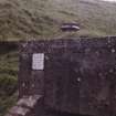
NX86SW 36.01 NX 84043 63124 Pillbox
NX86SW 36.02 NX 84333 63022 Observation Post
NX86SW 36.03 NX 84595 63667 Pillbox
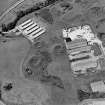
NX86SW 36.04 centred NX 8495 6325 (UNIT 1) Buildings; Fire Station; Magazines; Huts; Structures
and partly on map sheet NX86SE
NX86SW 36.05 centred NX 8445 6295 (UNIT 2) Buildings; Magazines; Huts
NX86SW 36.06 NX 84306 62674 Building; Offices
NX86SW 36.07 centred NX 8455 6245 Buildings; Huts; Magazines (Area South)
NX86SW 36.08 NX 84455 62425 Observation Post
NX86SW 36.09 NX 85475 63367 and NX 85501 63398 Gate-House; Building; Pillbox
N.B Falls on map sheet NX86SE
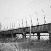
NX86SW 36.10 NX 84861 62950 Road Bridge
NX86SW 36.11 NX 84742 63332 Bridge (tramway)
NX86SW 36.12 NX 84851 63427 and NX 84864 63447 Bridge; Air-raid shelter
For earthwork, timber and stone castles within the area of this depot, see NX86SW 7, NX86SW 9, NX86SW 11. For Kirkgunzeon Lane (railway) Viaduct (NX 8485 6291 to 8489 6293), see NX86SW 39.02.
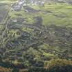
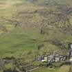
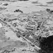
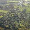
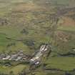
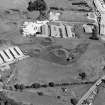
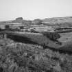
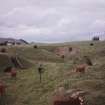
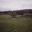
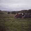
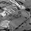
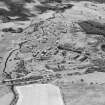
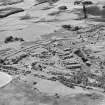
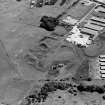
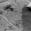
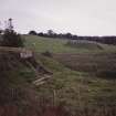
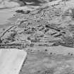
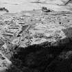
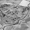
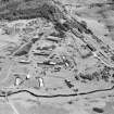
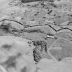
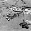
(World War II munitions factory - location cited as NX 845 630). The site comprises an extensive complex of earthworks, concrete- and brick-built structures and ponds, representing all stages of the manufacture of munitions. Pill boxes overlook the complex.
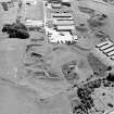
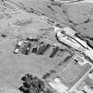
A road is soon to be constructed along the SW side, impinging on the the area of magazines. In advance of this, a detailed photographic record has been made of the total complex from the air, and of the area affected, from the ground. This, together with annotated plans, will be placed in the NMRS.
Sponsors: RCAHMS (air photograph grant), Dumfries and Galloway Regional Council, Dept. of Water and Sewerage.
J Brann 1993.
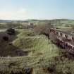
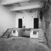
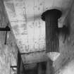
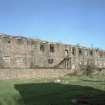
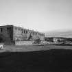
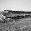
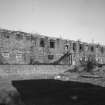
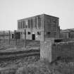
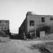
Edingham Minitions Factory. The monument comprises parts of a remarkably well-preserved example of a World War II explosives factory, with buildings and earthworks illustrating the function of the main elements of the production of explosives very clearly. The factory was used for the manufacture of nitroglycerine and cordite. The buildings were erected by Sir Robert McAlpine and Sons in 1940 and used throughout the war.
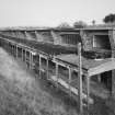
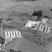
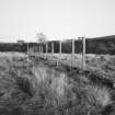
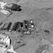
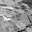
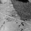
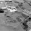
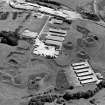
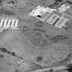
The complex covered 555 acres (225 ha), 334 acres (135 ha) within the factory security fence. A short siding ran from the railway near Southwick Station to the factory and a 2 mile (3.2km) length of main line ran inside the factory. There were 240 separate structures as originally built, and in addition to the railway the factory had its own complex road system. However, the buildings were designed to be of a temporary nature, and because of the inevitability of the deterioration in the materials used (poor quality brick and concrete) only a selection of the best-preserved and most representative structures are to be scheduled, including explosives manufacturing buildings, storage magazines, processing plants, elements of the transport system and the defensive pill-boxes.
The areas to be scheduled are as follows:
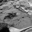
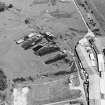
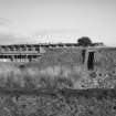
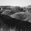
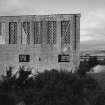
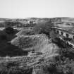
NX 8405 6280. Nitrating plant: four brick and concrete structures built within massive earthen banks, accessed by brick and concrete tunnels.
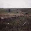
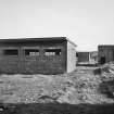
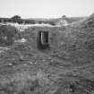
NX 8440 6225. Magazines: long, narrow brick and concrete structures built then covered with earth mounds to form safe underground storage for unstable explosives: many of the doors and fixtures still survive.
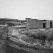
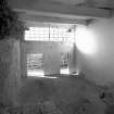
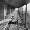
NX 8443 6285 and NX 8500 6325. Small scale processing sheds: wedge-shaped single storey brick buildings, lighted by small-pane windows high in the front elevation, over a concrete walkway. Doors, windows and some fixtures survive intact. Mostly single pile, but one double-pile building, with a flat roof.
NX 8487 6293. Viaduct [for which, see NX86SW 39.02].
NX 8500 6365. Batch processing plants.
NX 8404 6312, NX 8434 6302 and NX 8459 6366: three brick-built pillboxes defending the N perimeter of the site.
Information from Historic Scotland, scheduling document dated 5 October 1998.
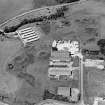
This extensive complex of military remains is situated on both sides of the (closed) Gretna - Stranraer railway (which presumably served it) to the NE of Dalbeattie. It covers portions of map sheets and SE and extends along both sides of Kirkgunzeon Lane, which here forms the boundary between the parishes of Urr and Kirkgunzeon. Part of the site is now occupied by the Edingham Industrial Estate.
Information from RCAHMS (RJCM), 1 December 1998.
Situated on the E side of the A711 N of Dalbeattie a WWII munitions factory covering a large area. Part of the site is now used as an Industrial Estate. Many of the original buildings are still extant, with others having been demolished.
J Guy 1999; NMRS MS 810/6, 81-2 (vol.1); 17-18 (vol.2).
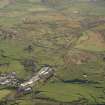
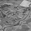
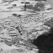
The Munitions Factory is visible on vertical air photographs (106G/Scot/UK 44, 3020-3022, flown 4 May 1946). which shows the layout of the processing sheds, magazines, transfer sidings and buildings, pillboxes and internal narrow gauge railway of about 84cm guage.
Information from RCAHMS (DE), April 2006
The Dalbeattie Royal Naval Armaments Depot and wartime Nitro-Glycerine and Gun cotton works are situated to the NE of Dalbeattie and astride the Kirkgunzeon Lane burn, totalling about 130 hectares of land. Most of the site is on low lying and marshy ground, except the extreme NE part which lies on the slopes of the rising ground.
The site was divided into to sections, Unit 1 and Unit 2, which duplicate each other and similar buildings are found in both areas. Each part also has a large canteen building and also replicates the processing facilities of each other.
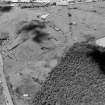
Most of the buildings are built in brick with concrete sills and lintels, though reinforced concrete has been used in the larger structures. The site also shows evidence of an extensive tramway system, particualrly low embankments and concrete bridges and in some cases the wooden or steel sleepers survive. There is also the remains of a system of concrete steam pipe supports to carry the pipe over the tramway of roads.
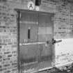
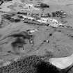
The site originally had two entrances, one at the NE extremity of the site, the gatehouse entrance being extant, providing direct access from Southwick Railway Station, the other was to the S of the large Charge Houses at the SW end. Three pillboxes were constructed to defend the site, two are on the W side and one has been built into the gate-house at the NE extremity. There are also two unusual observation posts which have the appearance of pillboxes, identical to each other, one situated on the N side, the other stands on high ground overlooking the magazines to the S.
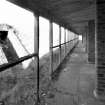
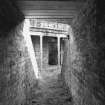
There are large earthworks, particularly around the Charge Houses and Expansion Magazines, but also many of those processes which may have been liable to blast. The Incoporation and Processing Houses all have letters rather than numbers found above the doors. Internally many official Fire safety and Air Raid Precaution signs are still extant.
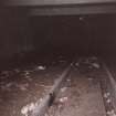
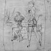
The most outstanding survival is the extensive graffiti which is found in, but not exclusively, the Processing and Incorporation Houses in Unit 1 with further examples in the drying and blending houses to the N. Most would appear to date from the late 1940's to mid-1950's, though a few have been found from the 1941-1945 period, the earliest being 1942. The graffiti would seem to consist mainly of masses of pencil calculations, probably reflecting the keeping of a tally of production with others working out money, possibly wages. There are many names recorded, most probably by those who worked there. Additionally are many poems, mostly of a semi-romantic nature, though some have a more earthy content. The drawings are mainly of women, though there are other examples, ships, aircraft and cartoon figures including 'Popeye' and Hitler. Some of the drawings have unfortunately been overdrawn or spoilt at a later date and the later examples are often much cruder and vulgar than the earlier ones. In some of the 'houses' more recent whitewashing has obscured much of the graffiti.
The doors of most buildings have been removed, the site is extensively used by the owner farmer for housing cattle and sheep and many of the buildings reflect this, being deep in waste products. However, some doors have also been removed as a result of recent Military exercises in urban warfare training which takes place on the site.
The site was also connected to the National Rail system by a series of standard guage sidings and loading bays on the E side where it is adjacent to the Dumfries to Stranraer main railway (The Port Line), which has now been closed and the track removed.
The RCAHMS is indebted to the owner of the land who gave permission to undertake the survey and Mr Richard Edkins, an interested local, who provided much of the information about the buildings and who continues to research the history of the site.
Visited by RCAHMS (DE, GL), 25 September 2006
Project
Recording Scotland's graffiti project was designed to review the range of historic and contemporary graffiti art across Scotland. It involved desk-based assessment and fieldwork at a number of example sites, to consider recording methodologies and dissemination practices.
Between 2016 and 2017, phase 1 of the project aimed to:
Aim 1: review a range of historic and contemporary graffiti art from across Scotland, already present in Canmore.
Aim2: undertake a research review of previous approaches to recording graffiti art in Canmore and other HERs, review and develop the current Thesaurus terms.
Aim 3: test and develop a range of recording methods within the following programmes or projects: Discovering the Clyde programme (1223), Scotland’s Urban Past (1222), Architecture and Industry projects, such as Urban Recording Projects (1028), Area Photographic Survey (311) and the Tomintoul and Glenlivet Landscape Partnership (1167).
Aim 4: the following test sites will be considered for research into the range of historic and contemporary graffiti. They will be analysed to demonstrate the different ages, contexts, styles and survivals of historic and contemporary graffiti: Polphail village (Canmore ID 299112), Scalan farmstead (170726), Cowcaddens Subway Station (243099), Croick Parish Church (12503), Dalbeattie Armament Depot (76279) and Dumbarton Rock (43376).
Aim 5: to research the potential for social media to play a role in crowd-sourcing information and archiving Scotland’s graffiti art.
In 2017-2019, phase 2 of the project aimed to:
Aim 1: To enhance the NRHE to the point at which it can be said to adequately represent the broad range of historic and modern graffiti that is evident throughout Scotland, and to explore ways by which that information can best be disseminated.
Aim 2: To develop guidelines that will convey the HES approach to researching and recording graffiti.
Aim 3: To write a specification for a book on Scotland’s graffiti.
Aim 4: To develop external partnerships to explore further ways to record graffiti and to identify and explore potential funding streams to enable further knowledge exchange and research.
The project was managed by Dr Alex Hale, with contributions from staff across Herirtage and Commercial and Tourism directorates.

