
Pricing Change
New pricing for orders of material from this site will come into place shortly. Charges for supply of digital images, digitisation on demand, prints and licensing will be altered.
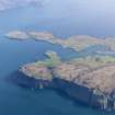
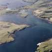
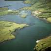
Canna, Sanday Footbridge And Shrine


Footbridge (Period Unassigned), Shrine (Period Unassigned)
Site Name Canna, Sanday Footbridge And Shrine
Classification Footbridge (Period Unassigned), Shrine (Period Unassigned)
Alternative Name(s) Canna Harbour; Canna-sanday Footbridge
Canmore ID 76070
Site Number NG20SE 27
NGR NG 2669 0493
NGR Description NG 2669 0493 to NG 2664 0500 and NG 2669 0493
Datum OSGB36 - NGR
Permalink http://canmore.org.uk/site/76070


- Council Highland
- Parish Small Isles
- Former Region Highland
- Former District Lochaber
- Former County Inverness-shire
NNG20SE 27 2669 0493 to 2664 0500 and 2669 0493
Shrine [NAT] (at NG 2669 0493)
OS 1:10,000 map, 1975.
Built 1905.
J L Campbell 1984.
A footbridge across the tidal channel between Canna and Sanday was first constructed in 1905. The bridge was severely damaged by winter storms and has been replaced; the earlier piers can still be seen in the channel.
A modern shrine has been erected at the SE end of the bridge on Sanday.
Visited by RCAHMS (ARG), 16 July 1996
J L Campbell 1984.
Field Visit (16 July 1996)
A footbridge across the tidal channel between Canna and Sanday was first constructed in 1905. The bridge was severely damaged by winter storms and has been replaced; the earlier piers can still be seen in the channel.
A modern shrine has been erected at the SE end of the bridge on Sanday.
Visited by RCAHMS (ARG), 16 July 1996
J L Campbell 1984.

