
Following the launch of trove.scot in February 2025 we are now planning the retiral of some of our webservices. Canmore will be switched off on 24th June 2025. Information about the closure can be found on the HES website: Retiral of HES web services | Historic Environment Scotland
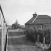
Altnabreac Station


Railway Station (19th Century) (1874)
Site Name Altnabreac Station
Classification Railway Station (19th Century) (1874)
Alternative Name(s) Altnabreac Halt
Canmore ID 7605
Site Number ND04NW 3
NGR ND 0037 4567
Datum OSGB36 - NGR
Permalink http://canmore.org.uk/site/7605


- Council Highland
- Parish Halkirk
- Former Region Highland
- Former District Caithness
- Former County Caithness
ND04NW 3 0037 4567
Altnabreac Station [NAT]
OS 1:10,000 map, 1991.
After Corrour (NN36NE 1), probably the most inaccessible station on the Scottish network, this intermediate station on the Inverness - Wick and Thurso ('Far North') line of the former Highland Rly was opened by the Sutherland and Caithness Rly on 28 July 1874. It remains in regular use by passenger traffic, as an unstaffed halt.
The plain but elegant station buildings originally cost #569 but were derelict by the early 1980's, when the adjacent hotel also closed. The ruined water tower still stands.
Information from RCAHMS (RJCM), 14 June 2001.
B Williams 1988; R V J Butt 1995.

