
Following the launch of trove.scot in February 2025 we are now planning the retiral of some of our webservices. Canmore will be switched off on 24th June 2025. Information about the closure can be found on the HES website: Retiral of HES web services | Historic Environment Scotland
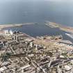
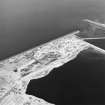
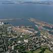
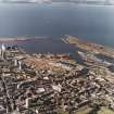
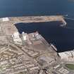
Edinburgh, Leith Docks, West Breakwater


Breakwater (Period Unassigned)
Site Name Edinburgh, Leith Docks, West Breakwater
Classification Breakwater (Period Unassigned)
Alternative Name(s) Western Harbour; Leith Roads; New West Breakwater
Canmore ID 75950
Site Number NT27NE 57.07
NGR NT 2619 7800
NGR Description NT 2619 7800 to NT 2547 7724
Datum OSGB36 - NGR
Permalink http://canmore.org.uk/site/75950


- Council Edinburgh, City Of
- Parish Edinburgh (Edinburgh, City Of)
- Former Region Lothian
- Former District City Of Edinburgh
- Former County Midlothian
NT27NE 57.07 2619 7800 to 2547 7724
For Lighthouse [Beacon] and Signal Tower at NT 26192 77986 and NT 26178 77984 respectively, see NT27NE 57.01.
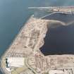
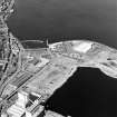
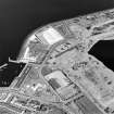
West Breakwater [NAT] (name centred NT 2570 7773]
OS 1:10,000 map, 1985.
This breakwater extends around the W side of the Western Harbour (formerly Leith Roads), for which see NT27NE 57.10.
It is noted as 'New West Breakwater (under construction)' on a plan of 1937.
Information from RCAHMS (RJCM), 13 June 2006.

