|
Photographs and Off-line Digital Images |
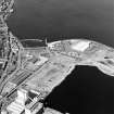
C 40287 CN |
RCAHMS Aerial Photography |
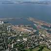
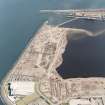
Edinburgh, oblique aerial view, taken from the S, showing Leith Docks in the top half of the photograph, and North Leith in the bottom half. |
1/9/1994 |
Item Level |
|
|
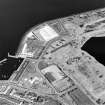
Photographs and Off-line Digital Images |
C 40289 CN |
RCAHMS Aerial Photography |
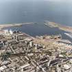
Edinburgh, oblique aerial view, taken from the SSE, centred on Leith Docks with North Leith in the bottom half. |
1/9/1994 |
Item Level |
|
|
Photographs and Off-line Digital Images |
ED 4744 |
|
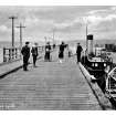
West Pier.
General view (postcard).
Titled: 'West Pier, Leith' |
c. 1920 |
Item Level |
|
 |
On-line Digital Images |
SC 610442 |
RCAHMS Aerial Photography |
Scanned image of colour photograph, oblique aerial view, taken from the SSE, centred on Leith Docks with North Leith in the bottom half. |
1/9/1994 |
Item Level |
|
 |
On-line Digital Images |
SC 610445 |
|
West Pier.
General view (postcard).
Titled: 'West Pier, Leith' |
|
Item Level |
|
|
Photographs and Off-line Digital Images |
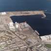
E 08344 |
RCAHMS Aerial Photography |
Oblique aerial view centred on the breakwater with the docks adjacent, taken from the S. |
2/5/2001 |
Item Level |
|
|
Photographs and Off-line Digital Images |
E 04083 CN |
RCAHMS Aerial Photography |
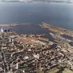
Oblique aerial view centred on the breakwater with the docks adjacent, taken from the SW. |
2/5/2001 |
Item Level |
|
|
Photographs and Off-line Digital Images |
E 08345 |
RCAHMS Aerial Photography |
Oblique aerial view centred on the breakwater with the docks, harbour and fishmarket adjacent, taken from the SSE. |
2/5/2001 |
Item Level |
|
|
Photographs and Off-line Digital Images |
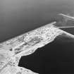
E 04087 CN |
RCAHMS Aerial Photography |
Oblique aerial view centred on the flour mills with the breakwater and docks adjacent, taken from the SSE. |
2/5/2001 |
Item Level |
|
|
Photographs and Off-line Digital Images |
E 08347 |
RCAHMS Aerial Photography |
Oblique aerial view centred on the harbour and fishmarket with the flour mills, docks and the breakwater adjacent, taken from the E. |
2/5/2001 |
Item Level |
|
 |
On-line Digital Images |
SC 1677872 |
RCAHMS Aerial Photography |
Edinburgh, oblique aerial view, taken from the S, showing Leith Docks in the top half of the photograph, and North Leith in the bottom half. |
1/9/1994 |
Item Level |
|
 |
On-line Digital Images |
SC 1677874 |
RCAHMS Aerial Photography |
Edinburgh, oblique aerial view, taken from the SSE, centred on Leith Docks with North Leith in the bottom half. |
1/9/1994 |
Item Level |
|
 |
On-line Digital Images |
SC 1677977 |
RCAHMS Aerial Photography |
Oblique aerial view centred on the breakwater with the docks adjacent, taken from the SW. |
2/5/2001 |
Item Level |
|
 |
On-line Digital Images |
SC 1677981 |
RCAHMS Aerial Photography |
Oblique aerial view centred on the flour mills with the breakwater and docks adjacent, taken from the SSE. |
2/5/2001 |
Item Level |
|
 |
On-line Digital Images |
SC 1677982 |
RCAHMS Aerial Photography |
Oblique aerial view centred on the breakwater with the docks adjacent, taken from the S. |
2/5/2001 |
Item Level |
|
 |
On-line Digital Images |
SC 1677983 |
RCAHMS Aerial Photography |
Oblique aerial view centred on the breakwater with the docks, harbour and fishmarket adjacent, taken from the SSE. |
2/5/2001 |
Item Level |
|
 |
On-line Digital Images |
SC 1677985 |
RCAHMS Aerial Photography |
Oblique aerial view centred on the harbour and fishmarket with the flour mills, docks and the breakwater adjacent, taken from the E. |
2/5/2001 |
Item Level |
|
|
Manuscripts |
MS 2221/01 |
Historic Scotland Archive Project |
Survey archive: Photographic register from Coastal Assessment Survey, 'The Firth of Forth from Dunbar to the Coast of Fife'. |
1996 |
Batch Level |
|


