
Pricing Change
New pricing for orders of material from this site will come into place shortly. Charges for supply of digital images, digitisation on demand, prints and licensing will be altered.
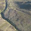
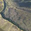
Caen Burn


Field System (Period Unassigned), Hut Circle(S) (Prehistoric)
Site Name Caen Burn
Classification Field System (Period Unassigned), Hut Circle(S) (Prehistoric)
Canmore ID 7488
Site Number ND01NW 8
NGR ND 010 191
Datum OSGB36 - NGR
Permalink http://canmore.org.uk/site/7488


- Council Highland
- Parish Kildonan
- Former Region Highland
- Former District Sutherland
- Former County Sutherland
ND01NW 8 010 191.
(ND 010 191) Hut Circles (NR). (Three shown A-C).
OS 6" map, (1964)
Three hut circles were located during field investigation.
Visited by OS (J L D) 25 May 1960.
On an E-facing moorland slope is a settlement of three heather-covered hut circles ('A'-'C'), with each hut built onto the slope. They are oval and range in size internally from 'A' 8.0m SE-NW by 7.0m to 'C' 7.0 m SE-NW by 6.0m. The walls have spread to an average of 2.0m broad, and the entrances are in the SE. There are a number of clearance heaps, particularly around 'B', and a few lynchets visible, but any field pattern has been obscured by peat cover.
Resurveyed at 1:10 560.
Visited by OS (J B) 12 May 1976.

