|
Photographs and Off-line Digital Images |
B 89073 NC |
General Collection: Newscuttings |
Newscutting from 'Falkirk Advertiser' 19 May 1993 regarding start of excavation in Hodge Street |
19/5/1993 |
Item Level |
|
|
Photographs and Off-line Digital Images |
B 89074 NC |
General Collection: Newscuttings |
Newscutting from 'Falkirk Herald' 8 July 1993 regarding excavation at Hodge Street (3 mounts) |
8/7/1993 |
Item Level |
|
|
Photographs and Off-line Digital Images |
B 89124 NC |
General Collection: Newscuttings |
Newscutting from 'The Scotsman' 16 September 1991 regarding discovery of Roman remains in excavation by Mr G Bailey of Falkirk District Council |
16/9/1991 |
Item Level |
|
|
Photographs and Off-line Digital Images |
B 92266 NC |
General Collection: Newscuttings |
Newscutting from 'The Times' 22 November 1993 regarding discovery. |
22/11/1993 |
Item Level |
|
|
Manuscripts |
MS 1334 |
|
Report: Excavation on the Roman Fort at Falkirk Pleasance, 1991/2. |
|
Item Level |
|
|
Manuscripts |
MS 2715 |
|
Report - Excavations at 1 St. Andre's Place, Falkirk, 2004. |
30/8/2004 |
Item Level |
|
|
Manuscripts |
MS 2723 |
|
Report - Excavations at 12 Rosehall Terrace, Falkirk, 2006. |
6/3/2006 |
Item Level |
|
|
Digital Files (Non-image) |
GV 007519 |
Records of Historic Scotland, Edinburgh, Scotland |
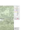
Map 3 of 8 from IV.I 1-8 - Series 1: Maps of the Antonine Wall at a scale of 1:25000 showing the proposed World Heritage Site, known forts and fortlets, camps, other features and the buffer zones. Maps were prepared for the nomination document to propose the extension of the Frontiers of the Roman Empire World Heritage Site through the addition of the Antonine Wall. |
2006 |
Item Level |
|
 |
On-line Digital Images |
SC 1926553 |
Records of Historic Scotland, Edinburgh, Scotland |
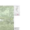
Map 3 of 8 from IV.I 1-8 - Series 1: Maps of the Antonine Wall at a scale of 1:25000 showing the proposed World Heritage Site, known forts and fortlets, camps, other features and the buffer zones. Maps were prepared for the nomination document to propose the extension of the Frontiers of the Roman Empire World Heritage Site through the addition of the Antonine Wall. |
2006 |
Item Level |
|
 |
On-line Digital Images |
SC 1927846 |
Records of Historic Scotland, Edinburgh, Scotland |
Map 3 of 8 from IV.2 1-8 - Series 2: Maps of the Antonine Wall at a scale of 1:25000 showing the proposed World Heritage Site, known forts and fortlets, camps, other features and the buffer zones. Maps were prepared for the nomination document to propose the extension of the Frontiers of the Roman Empire World Heritage Site through the addition of the Antonine Wall. |
2006 |
Item Level |
|
|
Digital Files (Non-image) |
GV 007526 |
Records of Historic Scotland, Edinburgh, Scotland |
Map 3 of 8 from IV.2 1-8 - Series 2: Maps of the Antonine Wall at a scale of 1:25000 showing the proposed World Heritage Site, known forts and fortlets, camps, other features and the buffer zones. Maps were prepared for the nomination document to propose the extension of the Frontiers of the Roman Empire World Heritage Site through the addition of the Antonine Wall. |
2006 |
Item Level |
|
|
Digital Files (Non-image) |
GV 007539 |
Records of Historic Scotland, Edinburgh, Scotland |
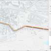
Map 10 of 39 from Series V. Maps of the Antonine Wall and its known features at a scale of 1:5000 showing the scheduled areas and the proposed World Heritage Site. Maps were prepared for the nomination document to propose the extension of the Frontiers of the Roman Empire World Heritage Site through the addition of the Antonine Wall. |
2006 |
Item Level |
|
 |
On-line Digital Images |
SC 1929319 |
Records of Historic Scotland, Edinburgh, Scotland |
Map 10 of 39 from Series V. Maps of the Antonine Wall and its known features at a scale of 1:5000 showing the scheduled areas and the proposed World Heritage Site. Maps were prepared for the nomination document to propose the extension of the Frontiers of the Roman Empire World Heritage Site through the addition of the Antonine Wall. |
2006 |
Item Level |
|
|
Digital Files (Non-image) |
GV 007596 |
Records of Historic Scotland, Edinburgh, Scotland |
Antonine Wall 1:25000 broadsheet map - created in three sections - this is the eastern section of the map |
2008 |
Item Level |
|
 |
On-line Digital Images |
SC 1970706 |
Records of Historic Scotland, Edinburgh, Scotland |
Antonine Wall 1:25000 broadsheet map |
2008 |
Item Level |
|
|
Digital Files (Non-image) |
TM 000310 |
Records of Historic Scotland, Edinburgh, Scotland |
Zip file including: a Dxf file containing the polygons created to show the components of the Antonine Wall, along with the associated forts, expansions and military way. Shapefiles containing the same data and an associated layer file. |
2007 |
Item Level |
|
|
Digital Files (Non-image) |
GV 008531 |
Records of Historic Scotland, Edinburgh, Scotland |
Map showing the Antonine Wall, the World Heritage Site area, the areas of the World Heritage Site in public ownership or care, the Buffer Zone and the Council boundaries. Created for the World Heritage Site nomination - Management plan. |
2006 |
Item Level |
|
 |
On-line Digital Images |
SC 2170806 |
Records of Historic Scotland, Edinburgh, Scotland |
Map showing the Antonine Wall, the World Heritage Site area, the areas of the World Heritage Site in public ownership or care, the Buffer Zone and the Council boundaries. Created for the World Heritage Site nomination - Management plan. |
2006 |
Item Level |
|


