
St Boswells, Charlesfield, Incendiary Bomb Munitions Plant And Depot


Armament Depot (20th Century)
Site Name St Boswells, Charlesfield, Incendiary Bomb Munitions Plant And Depot
Classification Armament Depot (20th Century)
Alternative Name(s) Charlesfield Munitions Factory
Canmore ID 74226
Site Number NT52NE 23
NGR NT 5857 2959
NGR Description Centred NT 5857 2959
Datum OSGB36 - NGR
Permalink http://canmore.org.uk/site/74226


First 100 images shown. See the Collections panel (below) for a link to all digital images.
- Council Scottish Borders, The
- Parish St Boswells
- Former Region Borders
- Former District Ettrick And Lauderdale
- Former County Roxburghshire
NT52NE 23 centred 5857 2959
For associated railway halt (opened in 1942 for depot workers) see NT52NE 24.11
Incendiary bomb production plant built c.1942. Production of incendiary bombs ceased in 1945, thereafter part of the site was used by the Royal Navy to store small arms and small guns. Use by the RN ceased in the early 1960s and several of the buildings were then used by famers, notably West Cumberland Farmers for storage and animal husbandry along with some light industrial units. Much of the site has recently been cleared by the farmer.
Information from J Dent, The Borders Council Archaeologist to RCAHMS, August 1999
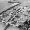
The World War Two incendiary bomb factory at Charlesfield is situated to the S of St Boswells. The site is now an industrial estate, some of the buildings have been cleared, but many still survive. The factory later became a Royal Navy Armament Depot.
J Guy 1999; NMRS MS 810/8, 25-6
Charlesfield bomb production plant is visible on RAF WW II oblique aerial photographs taken in 1943 and 1944 (No.1 CAM, 14265-14266 and 24599 and 24604, flown 23 June 1943 and 10 June 1944 respectively). The 1943 images show in detail the internal layout of the buildings and structures. In addition the rail connection to the Edinburgh-Hawick-Carlisle main railway is also prominent.
Information from RCAHMS (DE), March 2006.
Note (5 August 2024)
Factory built and opened by ICI to fulfill Ministry of Aircraft Production contracts during World War 2. Its function was to fill and assemble Incendiary Bombs. Building began in November 1942 and was completed in July 1943. The site covered 74 acres, had 2.5 miles of main line railway track and 67 buildings. The maximum workforce reached 1280 of which 900 were women. MS8270/19
Sbc Note
Visibility: Upstanding structure, which may not be intact.
Information from Scottish Borders Council.
Sbc Note
An incomplete Hunter Penrose camera, consisting of a substantial mahogany, brass and iron frame, cranked length adjustment, and bellows c.3 metres long. No lenses survive and the remains are built into the fabric of the building, in so far that an adjoining room is connected by a window through which the camera projected. The large size of this camera suggests that is was used for military intelligence purposes, possible the enlargement of aerial photographs, and that it required two rooms to accommodate it.
Information from Scottish Borders Council Historic Environment Record
(n.d.)

