
Pricing Change
New pricing for orders of material from this site will come into place shortly. Charges for supply of digital images, digitisation on demand, prints and licensing will be altered.
Ousdale


Township (Period Unassigned)
Site Name Ousdale
Classification Township (Period Unassigned)
Alternative Name(s) Lat 317a-g
Canmore ID 7422
Site Number ND01NE 9
NGR ND 069 187
Datum OSGB36 - NGR
Permalink http://canmore.org.uk/site/7422


- Council Highland
- Parish Latheron
- Former Region Highland
- Former District Caithness
- Former County Caithness
NC01NE 9 069 187.
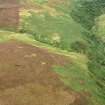
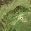
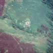
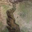
A post medieval croft complex with yards and kilns. The five crofts range from 4 by 7m to 23.5 by 5m, all except the smallest being subdivided. One kiln, 6.25 by 4m, with its flue surviving, lies adjacent to a stream. The other kiln relatively upstanding, with steps and flue surviving, is set into a bank.
C Batey 1982
A township comprising three unroofed buildings, two of which have adjoining enclosures and the other is a long building, is depicted on the 1st edition of the OS 6-inch map (Caithness 1877, sheet xliv). Six unroofed buildings, of which five are sud-divided, and two enclosures are shown on the current edition of the OS 1:10,560 map (1964).
Information from RCAHMS (AKK) 23 November 1995.
Project (1980 - 1982)
Field Visit (1982)
A post medieval croft complex with yards and kilns. The five crofts range from 4 by 7m to 23.5 by 5m, all except the smallest being subdivided. One kiln, 6.25 by 4m, with its flue surviving, lies adjacent to a stream. The other kiln relatively upstanding, with steps and flue surviving, is set into a bank.
C Batey 1982

