
Lerwick, General


Burgh (Medieval), Town (17th Century)
Site Name Lerwick, General
Classification Burgh (Medieval), Town (17th Century)
Alternative Name(s) Lerwick Village
Canmore ID 73777
Site Number HU44SE 60
NGR HU 47524 41241
NGR Description Centred on HU 47524 41241
Datum OSGB36 - NGR
Permalink http://canmore.org.uk/site/73777


First 100 images shown. See the Collections panel (below) for a link to all digital images.
- Council Shetland Islands
- Parish Lerwick
- Former Region Shetland Islands Area
- Former District Shetland
- Former County Shetland
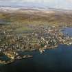
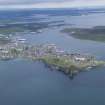
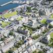
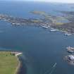
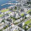
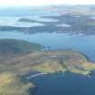
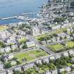
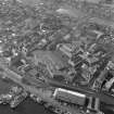
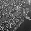
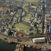
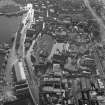
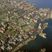
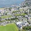
Lerwick is Scotland's most northerly town, and owes its position to the large, sheltered harbour provided by the Bressay Sound. Founded in the 17th century, by the mid-18th it contained about three hundred houses. The expansion continued into the 19th century, the town becoming a Burgh of Barony in 1819. Merchants operating in Lerwick built Lodberries, houses with attached private wharves and stores. A number of these structures still stand, giving the town's waterfront a distinctive appearance.
Information from RCAHMS (SC) 20 August 2007
Gifford, J 1992
NMRS REFERENCE:
ARCHITECT of New Town lay out : John M. Aitken.
ARCHITECT of Market Place lay out : John M. Aitken.
EXTERNAL REFERENCE:
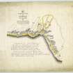
Scottish Record Office
RHP 9112 late 19th century - plan of part of town.
National Library
Zetland (MS 3037) plate II - 1 water colour.
Publication Account (1997)
Bressay Sound is a kilometre wide stretch of water between the island of Bressay and the curve of the peninsula now occupied by the town of Lerwick, and it has provided ideal shelter for large numbers of ships, especially in the great days of the haaf and herring fishing. Yet Lerwick is quite a young town, founded only in the 17th century. Its bay was named by the Norsemen, leir vik or mud bay, but this part of Shetland was unattractive for early settlement, the land being relatively infertile, and it was Scalloway on the west coast that first developed as the capital for the islands. By the 17th century, Bressay Sound had been adopted by Dutch fishermen as a base, and a seasonal trading post developed at Lerwick specifically to do business with the Hollanders. But it was the war between Britain and Holland in the mid 17th century that led to the permanent foundation of the town, with the construction of Fort Charlotte (no. 2) to guard the anchorage in Bressay Sound for British warships.
Apart from the fort, the oldest buildings surviving in recognisable form in Lerwick belong to the 18th century and are to be found along the seaward side of Commercial Street, the dwelling-houses fronting on to the street and the lodberries behind, private wharves built projecting into the sea with
storehouses and facilities for landing goods. No. 10 is a fine example, recently restored, of a merchant's house fronting on to the street: two-stories high with an attic, the house is rubble-built with freestone dressings to the windows and front door, crow stepped gables and a slated roof, and behind it there is a lodberry. The buildings now known simply as The Lodberry consist of a single-storey house which acted as a shop fronting on to the street, with a two-storey house attached, gable-end on, to the rear, and a lodberry with its loading door and ventilated storehouse above. The Lerwick waterfront, like that at Stromness, has a very distinctive and attractive appearance, for the projecting lodberries are all slightly different in size and design, as their form, and latterly function, has developed over the last two centuries. The Queen's Hotel has converted its two lodberries, probably of early 19th-century date, to accommodation wings.
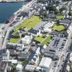
A restored 18th-century merchant's house is the Bod of Gremista (no.7), built beside a fish-drying beach at the very north end of modern Lerwick. At the junction of Commercial Street and Church Road is the old town tolbooth, which was built in the late 1760s on the site of an earlier tolbooth of the 17th century. Most of the stone was quarried in Bressay, but the sandstone for the quoins and scrolled skewputts at each corner of the building was imported from mainland Scodand. A neat central clock-tower existed formerly, and can be seen in Dryden's illustration. This was added as a belfry in 1772 and a clock was added in the following decade, but the entire steeple was removed in 1927, thus altering the character of the building. But by then it was no longer a tolbooth. It had been quite unsuitable as a jail, because the basement cells were damp, and in 1838 Fort Charlotte became the main jailhouse. From 1878 the old tolbooth became a post office, and some of its original functions were taken over by the new Town Hall of the early 1880s. From 1912 the building was converted into a Fishermen's Institute and it is now occupied by the British Red Cross Society.
Several fine public buildings were erected in the late 19th century, including St Magnus Episcopal Church (1864) with its crenellated tower (1891) and stained glass, and the attractively modest Sheriff Court (1875), designed by David Rhind of Edinburgh. Far more ornate is the imposing Town Hall (1882-3), designed in Scottish Baronial style by Alexander Ross, with its angle-turrets, oriel window over the main entrance and crenellated clock-tower, together with many decorative details including a remarkable series of stained glass windows in the first-floor ballroom.
Information from ‘Exploring Scotland’s Heritage: Shetland’, (1997).

