
Lochore, Mary Colliery


Colliery (20th Century) (1904)-(1966)
Site Name Lochore, Mary Colliery
Classification Colliery (20th Century) (1904)-(1966)
Alternative Name(s) Lochore Colliery; Loch Ore; Mary Colliery Winding Gear Head Frame
Canmore ID 72770
Site Number NT19NE 27
NGR NT 17033 96481
NGR Description centred; Shafts at NT 1717 9626 and NT1704 9619
Datum OSGB36 - NGR
Permalink http://canmore.org.uk/site/72770


- Council Fife
- Parish Ballingry
- Former Region Fife
- Former District Dunfermline
- Former County Fife
Field Visit (18 September 1991)
NT19NE 27 1703 9647
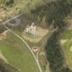
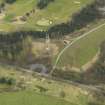
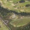
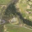
The winding tower of Lochore Colliery (Mary Pit) which is depicted on the revision of the 2nd edition of the OS 25-inch map (Fifeshire, 1914, sheet xxvi.16), has been preserved as a monument in the NW corner of Lochore Golf Course.
This colliery had a very long life span, opened in 1904 by the Fife Coal Company, and closing in 1966. The mine consisted of two shafts, the deepest being some 285 fathoms producing both house and navigation coal.
The shaft has been capped with a slab of concrete, as has a second shaft (not visited) on the golf course to the E. The surrounding area has been reclaimed on a massive scale and numerous other spoil tips and mineheads depicted in the vicinity on earlier editions of the OS maps have now disappeared (NT 168 964, 172 965 and 173 963).
Others lie beneath housing in Ballingry (NT 177 974, 178 975 and 179 975). A new visitor centre (NT19NE 30) lies adjacent to the site of one of the miners rows that were built for the mines in this area.
(Cleish91 379)
Visited by RCAHMS (SPH) 18 September 1991.
Note (2006)
(Location cited as NT 1717 9636). MARY (also known as Lochore colliery)
Location: Lochore
Previous Owners: Fife Coal Company
Types of Coal: House, Navigation
Sinking/Production Commenced: 1904, No. 2 shaft in 1923
Year Closed: 1966
Year Abandoned: 1968
Average Workforce: 614
Peak Workforce: 780
Peak Year: 1957
Shaft/Mine Details: 2 shafts, No. 1 (ventilation) 201m (NT 1717 9636), and No. 2 521m deep (NT 1704 9619), built in 1923 with a reinforced concrete headframe. Original sinking in 1904 took it to 613m, at the time the deepest mine in Scotland.
Details in 1948: Output 800 tons per day, 211,355 per annum. 647 employees. Baum-type washer (wet coal cleaning system). Canteen (packed meal), first-aid room. AC electricity. Report dated 10-08-1948.
Other Details: Reconstruction programme under way in 1946 included the introduction underground of large mine cars and locomotive haulage. New car handling plant was added at the surface, as was a redd disposal plant. Reinforced concrete headframe for No. 2 shaft now survives as part of Lochore Meadows Country Park.
M K Oglethorpe 2006.
Publication Account (23 November 2023)
The reinforced concrete winding gear frame of Mary Pit No.2 was begun in 1919. It was built using the Kahn system by the Trussed Concrete Steel Company (later TRUSCON). This was the first concrete reinforced pit winding headgear in Scotland.
The Engineer (9 January 1920, 48)
HES, Heritage Research Service (Miriam McDonald), 23 November 2023.

