
Milton Loch


Island (Period Unassigned)
Site Name Milton Loch
Classification Island (Period Unassigned)
Alternative Name(s) Milton Loch 4
Canmore ID 72521
Site Number NX87SW 16
NGR NX 8381 7152
Datum OSGB36 - NGR
Permalink http://canmore.org.uk/site/72521


- Council Dumfries And Galloway
- Parish Urr
- Former Region Dumfries And Galloway
- Former District Stewartry
- Former County Kirkcudbrightshire
NX87SW 16 8381 7152
Dixon notes a possible fourth crannog at NX 8375 7144 but states that this is only some 75m from his crannog (NX87SW 15), and on the same bedrock outcrop.
Location confirmed by Dixon (10 October 1990) as feature depicted on OS 1:10,000 (1980) map at NX 8381 7152).
T N Dixon 1989.
As the underwater component of Phase 2 of the South West Crannog Survey, the state of preservation of 14 crannog sites was evaluated in 12 lochs throughout Dumfries and Galloway as part of the Scottish Wetland Archaeology Programme (SWAP).
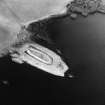
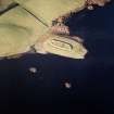
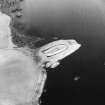
NX 8381 7152 Milton Loch IV (NX87SW 16). The possible fourth crannog in Milton Loch, located halfway along the promontory on which Milton Loch III sits, was observed to be entirely natural and as such should no longer be considered a crannog. However, a length of drystone walling, c 2m long and 0.8m high, runs along the S side of this tree-covered island. A hearth of unknown antiquity (though recently used) is evidenced by two long flat stones. The island is otherwise featureless.
Sponsors: HS, Scottish Trust for Archaeological Research, AOC Archaeology Group, University of Nottingham
M G Cavers and J C Henderson 2002.
Milton Loch 4 (Urr catchment): location cited as NX 8381 7152.
In 1989 Dixon noted a possible fourth crannog some 75m W of Milton Loch 3 (NX87SW 15).
The remains of this possible crannog were surveyed in July 2002 during the 2nd phase of the South-West Scotland Crannog Survey, with the intention of establishing an effective system of monitoring the rate of organic decay. It was not considered to be a crannog, and so not recommended for continued monitoring.
This monument appears as a tree-covered island resting on the same bedrock outcrop as Milton Loch 3 (NX87SW 15). It comprises outcropping bedrock, and is apparently entirely natural in origin.
The mound is featureless apart from a short length of drystone walling on its S side and a hearth of unknown antiquity (but recently used).
J C Henderson, B A Crone and M G Cavers 2003.

