|
Photographs and Off-line Digital Images |
DC 47351/8 |
Records of the Ordnance Survey, Southampton, Hampshire, England |
Ordnance Survey 6-inch to the mile Provisional Edition, revision of 1913 with additions in 1946.
Additional annotations by Ordnance Survey for the Antonine Wall map covering the parishes of Falkirk and Cumbernauld with Castlecary. |
c. 1946 |
Item Level |
|
 |
On-line Digital Images |
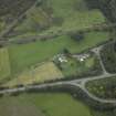
DP 021000 |
RCAHMS Aerial Photography Digital |
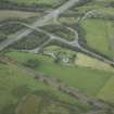
Oblique aerial view centred on the site of the Roman fort and Roman road, taken from the SE. |
8/9/2006 |
Item Level |
|
 |
On-line Digital Images |
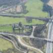
DP 021001 |
RCAHMS Aerial Photography Digital |
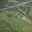
Oblique aerial view centred on the site of the Roman fort and Roman road, taken from the ESE. |
8/9/2006 |
Item Level |
|
 |
On-line Digital Images |
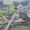
DP 021002 |
RCAHMS Aerial Photography Digital |
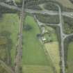
Oblique aerial view centred on the site of the Roman fort and Roman road, taken from the E. |
8/9/2006 |
Item Level |
|
 |
On-line Digital Images |
DP 021003 |
RCAHMS Aerial Photography Digital |
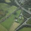
Oblique aerial view centred on the site of the Roman fort and Roman road, taken from the NE. |
8/9/2006 |
Item Level |
|
 |
On-line Digital Images |
DP 021004 |
RCAHMS Aerial Photography Digital |
Oblique aerial view centred on the site of the Roman fort and Roman road, taken from the N. |
8/9/2006 |
Item Level |
|
 |
On-line Digital Images |
DP 249529 |
Historic Environment Scotland |
Oblique aerial view. |
24/3/2017 |
Item Level |
|
 |
On-line Digital Images |
DP 249530 |
Historic Environment Scotland |
Oblique aerial view. |
24/3/2017 |
Item Level |
|
|
All Other |
551 166/1/1 |
Records of the Ordnance Survey, Southampton, Hampshire, England |
Archaeological site card index ('495' cards) |
1947 |
Sub-Group Level |
|


