
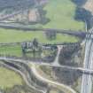
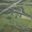
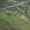
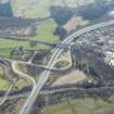
Belstane - Castlecary


Roman Road (Roman)
Site Name Belstane - Castlecary
Classification Roman Road (Roman)
Canmore ID 72271
Site Number NS77NE 61
NGR NS 7893 7818
NGR Description From NS 8016 7570 to NS 7893 7818
Datum OSGB36 - NGR
Permalink http://canmore.org.uk/site/72271


- Council Falkirk
- Parish Falkirk
- Former Region Central
- Former District Falkirk
- Former County Stirlingshire
NS77NE 61 from 8016 7570 to 7893 7818. RX 3.
From the fort at Castlecary (NS77NE 24) a short branch road led southward to the farm at Crowbank, situated upon the higher land, where there seems to have been some kind of look-out station (see NS87NW 8; alleged Roman walling at NS 8016 7570). Its course is traceable through the woodland SW of the fort till it falls into the present road leading towards Walton farm, following this for 300 yds and then diverging again on the E side through another wood. On reaching a small stream the road turns eastward along its N bank, where it is visible as a terrace with some exposure of the metalling and kerbstones. Then, opposite Walton farm, it crosses the stream and ascends the steep southern bank by a well-preserved terrace, joining the present road where this turns sharply S at the farm and following it for a few yards before diverging into the fields on the E, where its ploughed-up stones are sometimes visible. It now takes a straight course towards Crowbank, passing through a small plantation, Bandominie South Wood, where it is fairly visible. It crosses the Walton Burn by terraces down the steep banks, resuming the line beyond, and the road becomes very plain as it approaches Crowbank. There are no indications that it ever continued beyond.
J M Davidson 1952; I D Margary 1957.
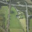
NS 8016 7570 to NS 7998 7607 Metalled farm track on course.
NS 7998 7607 to NS 7926 7715 No trace.
NS 7926 7715 to NS 7916 7727 Modern road on course.
NS 7916 7727 to NS 7911 7735 Old farm track.
NS 7911 7735 to NS 7885 7740 Turf-covered metalled road 7.5m wide. Traces of ditch on N side. Massive kerb stones visible at NS 7889 7739, and massive stone metalling exposed at NS 7906 7736. The only evidence of a possible Roman road.
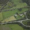
NS 7885 7740 to NS 7885 7774 No trace.
NS 7885 7774 to NS 7889 7800 Modern road on course.
NS 7889 7800 to NS 7890 7811 Old terraced track 5m wide with field access track diverging northwards.
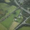
NS 7890 7811 to NS 7893 7818 No trace.
Visited by OS (WDJ) 6 April 1967.

