|
Prints and Drawings |
DC 25001 PO |
Records of the Royal Commission on the Ancient and Historical Monuments of Scotland (RCAHMS), Edinbu |
Distribution map of hut-circles in the Strath of Kildonan |
1992 |
Item Level |
|
|
Prints and Drawings |
DC 25002 PO |
Records of the Royal Commission on the Ancient and Historical Monuments of Scotland (RCAHMS), Edinbu |
Distribution map of hut-circles in the Strath of Kildonan |
1992 |
Item Level |
|
|
Manuscripts |
MS 731/1 |
Records of the Royal Commission on the Ancient and Historical Monuments of Scotland (RCAHMS), Edinbu |
Printed and bound copies of the RCAHMSALS Field Survey Database entries (1-479), Strath of Kildonan |
1991 |
Item Level |
|
|
Prints and Drawings |
DC 21614 |
Records of the Royal Commission on the Ancient and Historical Monuments of Scotland (RCAHMS), Edinbu |
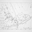
Plan of archaeological landscape |
1991 |
Item Level |
|
|
Prints and Drawings |
DC 21623 PO |
Records of the Royal Commission on the Ancient and Historical Monuments of Scotland (RCAHMS), Edinbu |
Plan of archaeological landscape |
1991 |
Item Level |
|
|
Photographs and Off-line Digital Images |
B 83705 CS |
|
Kildonan, Ach an Fhionnfhuaraidh, hut circle, field system |
1/1/1991 |
Item Level |
|
|
Digital Files (Non-image) |
DX 001419 |
Records of the Royal Commission on the Ancient and Historical Monuments of Scotland (RCAHMS), Edinbu |
RCAHMS Structures Database, Strath of Kildonan |
1991 |
Item Level |
|
 |
On-line Digital Images |
SC 2350876 |
Records of the Ordnance Survey, Southampton, Hampshire, England |
Ach An Fhionnfhuaraidh, NC92SW 35, Ordnance Survey index card, page number 1, Recto |
c. 1958 |
Item Level |
|
 |
On-line Digital Images |
SC 2667818 |
Records of the Royal Commission on the Ancient and Historical Monuments of Scotland (RCAHMS), Edinbu |
Plan of archaeological landscape |
1991 |
Item Level |
|
|
All Other |
551 166/1/1 |
Records of the Ordnance Survey, Southampton, Hampshire, England |
Archaeological site card index ('495' cards) |
1947 |
Sub-Group Level |
|


