
Pricing Change
New pricing for orders of material from this site will come into place shortly. Charges for supply of digital images, digitisation on demand, prints and licensing will be altered.
Monzie


Pit(S) (Period Unknown), Square Barrow(S) (Iron Age)(Possible)
Site Name Monzie
Classification Pit(S) (Period Unknown), Square Barrow(S) (Iron Age)(Possible)
Canmore ID 71785
Site Number NN82SE 78.04
NGR NN 8807 2425
Datum OSGB36 - NGR
Permalink http://canmore.org.uk/site/71785


- Council Perth And Kinross
- Parish Crieff
- Former Region Tayside
- Former District Perth And Kinross
- Former County Perthshire
Aerial Photographic Transcription (5 February 1997 - 18 February 1997)
An aerial transcription was produced from oblique aerial photographs. Information from Historic Environment Scotland (BM) 31 March 2017.
Field Visit (26 November 1997)
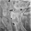
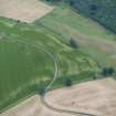
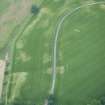
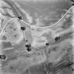
NN82SE 78.04 8807 2425
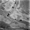
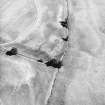
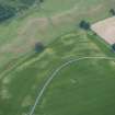
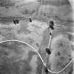
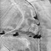
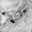
Cropmarks on oblique aerial photographs (RCAHMSAP 1989) reveal what may be two square barrows and a scatter of pits disposed along a low ridge on the leading edge of a terrace to the E of the Shaggie Burn. The northern of the two barrows (EARNAP 132, NN 8807 2425) is the clearest, measuring about 8m across overall, with a central burial pit. The second, poorly defined, barrow lies to the SE (NN 8808 2423). The scatter of pits lies along the leading edge of the terrace to the N of the barrows and are of unknown function.
(EARNAP 132)
Visited by RCAHMS (DCC) 26 November 1997

