
Yester


Fort (Prehistoric)
Site Name Yester
Classification Fort (Prehistoric)
Alternative Name(s) Yester Castle
Canmore ID 71509
Site Number NT56NE 50
NGR NT 55560 66764
Datum OSGB36 - NGR
Permalink http://canmore.org.uk/site/71509


- Council East Lothian
- Parish Yester
- Former Region Lothian
- Former District East Lothian
- Former County East Lothian
NT56NE 50 NT 55560 66764
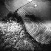
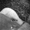
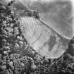
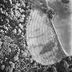
NT 555 667. Fort, Yester: visible on aerial photographs.
(Undated) information in NMRS.
Scheduled as Yester Castle, fort.
Information from Historic Scotland, scheduling document dated 21 March 1994.
Aerial Photographic Transcription (7 May 1991 - 14 June 1991)
An aerial transcription was produced from oblique aerial photographs. Information from Historic Environment Scotland (BM) 31 March 2017.
Note (9 December 2015 - 20 October 2016)
This fort is situated on a hillock on the escarpment overlooking Yester Castle from the W. This gully seems to have been sufficiently deep to protect the E flank, while elsewhere cropmarks have revealed an arc of up to three ditches, though the cropmarks are not particularly well defined on the W and S arcs. All three ditches are clearly visible only on the N, where the two inner ones are about 5m in breadth and set 20m apart, but they seem to converge around the SW flank; the rather narrower outermost one is no more than 3m broad and is only visible on the N. The featureless interior is semi-circular on plan and measures about 85m from N to S by 55m transversely (0.33ha) within the inner ditch; allowing for the presence of an inner rampart, it probably extends to some 0.25ha. The position of the entrance is not known.
Information from An Atlas of Hillforts of Great Britain and Ireland – 20 October 2016. Atlas of Hillforts SC3856
Desk Based Assessment (4 April 2022 - 14 April 2022)
A desk-based assessment has been carried out that has established that there are surviving remains ranging from national heritage value (high sensitivity) to local heritage value (low sensitivity) within the Forest Plan Site. These include the scheduled medieval ruins of Yester Castle; extensive areas of rig and furrow cultivation dating from the medieval to post-medieval period; enclosures and tracks relating to the layout of the Inventory Garden and Designed Landscape of Yester Estate; and various field banks and quarries probably dating to the development of the medieval estate and later uses in the 18th and 19th century. Furthermore, several designated heritage assets are situated in immediate proximity to the Forest Plan Site. Twelve of these remains would be directly affected to a greater or lesser degree by the Forest Plan and mitigation measures have been recommended to offset the predicted effects. The findings of the study indicate that there is a moderate potential for previously unrecorded archaeological remains to survive within the Forest Plan Site.
Information from OASIS Id: cfaarcha1-436583 (G Mudie) 2022

