
Skye, Geary


Township (Post Medieval)
Site Name Skye, Geary
Classification Township (Post Medieval)
Alternative Name(s) Garry
Canmore ID 71245
Site Number NG26SE 2
NGR NG 2655 6162
Datum OSGB36 - NGR
Permalink http://canmore.org.uk/site/71245


- Council Highland
- Parish Duirinish
- Former Region Highland
- Former District Skye And Lochalsh
- Former County Inverness-shire
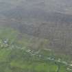
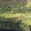
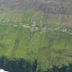
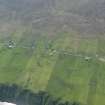
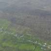
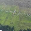
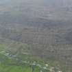
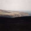
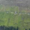
Geary Good example of a post-clearance crofting settlement - a strictly linear pattern of houses (many as late as the 1930s) strung out above the road, with stone byres on the long narrow crofts that slope down towards the sea below.
Taken from "Western Seaboard: An Illustrated Architectural Guide", by Mary Miers, 2008. Published by the Rutland Press http://www.rias.org.uk

Field Visit (15 November 1990)
NG26SE 2 26 61
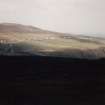
The crofting township of Geary runs up the E side of the Waternish Peninsula in a strip up to 600m wide and 1900m long. The majority of structures are situated along the line of the public road and the present layout is very similar to that of the 2nd edition of the Ordnance Survey map of 1904. The 1st edition of the Ordnance Survey map of 1880 (Island of Skye &c., Inverness-shire, 1880-1904, sheet ix) shows a less formal layout, but within the crofting strips. Only one group of structures may be survivals of a pre-crofting settlement. Centred on NG 264 616 they lie on the line of the earlier road shown on the 1st edition of the Ordnance Survey map (ibid), but redundant by the time of the 2nd edition of the Ordnance Survey map (ibid). Geary School (NG 2624 6123 becomes redundant between the 1st and 2nd editions of the Ordnance Survey maps (ibid), during which time Knockbreck School on the Geary-Halistra road was built. Many of the crofts have been intensively improved, and ridging survives only in patches. There are also fragments of what may be earlier field banks underlying the croft walls. Clearance heaps, often substantial and well-built, are scattered amongst the fields. Also scattered amongst the fields are circular or sub-rectangular drystone enclosures without entrances, most of which are depicted on the 1st edition of the Ordnance Survey map (ibid), and which may be hay-rick enclosures of some kind. To the W of the crofting lands are two, and possibly three, lines of banks running from N to S, which may represent earlier boundaries of the settlement at Geary.
The farm of "Garrie" is first documented in 1683, when there were six tenants (R C MacLeod 1928, Vol.I) and by 1788 there were fourteen married couples in a total population of 55 (SRO GD 9/3 Abstract minutes of British Fisheries Society 1786-1788). Its reorganisation into a crofting township belongs to the first part of the 19th century.
(WAT90 384-459)
Visited by RCAHMS (DCC) 15 November 1990.
Note (11 November 1996)
A township, comprising sixty-two roofed, thirteen unroofed buildings and fourteen unroofed structures is depicted on the 1st edition of the OS 6-inch map (Inverness-shire, Isle of Skye 1880, sheet ix).
Forty-one roofed, three partially roofed and fifty-four unroofed buildings are shown on the current edition of the OS 1:10560 map (1968).
Information from RCAHMS (AKK), 11 November 1996.

