|
Prints and Drawings |
DC 20890 |
Records of the Royal Commission on the Ancient and Historical Monuments of Scotland (RCAHMS), Edinbu |
Location map: Areas surveyed, Waternish, Skye. (PMT Copy). |
1990 |
Item Level |
|
|
Prints and Drawings |
DC 20891 |
Records of the Royal Commission on the Ancient and Historical Monuments of Scotland (RCAHMS), Edinbu |
Distribution map: Townships (c.1700), buildings, shieling mounds, Waternish, Skye. (PMT Copy). |
1990 |
Item Level |
|
|
Prints and Drawings |
DC 25549 |
Records of the Royal Commission on the Ancient and Historical Monuments of Scotland (RCAHMS), Edinbu |
Skye, Duirinish, Dun Hallin.
ALS Waternish survey working drawings |
1990 |
Item Level |
|
|
Manuscripts |
MS 731/2 |
Records of the Royal Commission on the Ancient and Historical Monuments of Scotland (RCAHMS), Edinbu |
Printout of RCAHMS ALS database for the Archaeological Survey of Waternish. |
1990 |
Item Level |
|
|
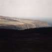
Photographs and Off-line Digital Images |
B 19407 CN |
|
|
1990 |
Item Level |
|
|
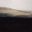
Photographs and Off-line Digital Images |
B 19408 CN |
|
|
1990 |
Item Level |
|
 |
On-line Digital Images |
DP 076589 |
RCAHMS Aerial Photography Digital |
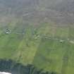
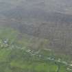
General oblique aerial view of the crofting landscape at Geary, taken from the E. |
31/5/2009 |
Item Level |
|
 |
On-line Digital Images |
DP 076591 |
RCAHMS Aerial Photography Digital |
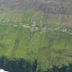
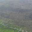
General oblique aerial view of the crofting landscape at Geary, taken from the E. |
31/5/2009 |
Item Level |
|
 |
On-line Digital Images |
DP 076592 |
RCAHMS Aerial Photography Digital |
General oblique aerial view of the crofting landscape at Geary, taken from the E. |
31/5/2009 |
Item Level |
|
 |
On-line Digital Images |
DP 076593 |
RCAHMS Aerial Photography Digital |
General oblique aerial view of the crofting landscape at Geary, taken from the E. |
31/5/2009 |
Item Level |
|
 |
On-line Digital Images |
DP 076594 |
RCAHMS Aerial Photography Digital |
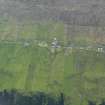
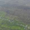
General oblique aerial view of the crofting landscape and the remains of the head dykes at Geary, taken from the ENE. |
31/5/2009 |
Item Level |
|
 |
On-line Digital Images |
DP 076595 |
RCAHMS Aerial Photography Digital |
General oblique aerial view of the crofting landscape and the remains of the head dykes at Geary, taken from the ENE. |
31/5/2009 |
Item Level |
|
 |
On-line Digital Images |
DP 076596 |
RCAHMS Aerial Photography Digital |
General oblique aerial view of the crofting landscape and the remains of the head dykes at Geary, taken from the ENE. |
31/5/2009 |
Item Level |
|
|
Photographs and Off-line Digital Images |
H 98362 CS |
Papers of Dr J N Graham Ritchie, and Dr Anna Ritchie, archaeologists, Edinburgh, Scotland |
View of Geary township, Waternish, Skye. |
11/1990 |
Item Level |
|
 |
On-line Digital Images |
DP 094793 |
RCAHMS Aerial Photography Digital |
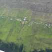
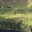
Oblique aerial view of Geary, looking W. |
31/8/2010 |
Item Level |
|
|
Digital Files (Non-image) |
DX 001420 |
Records of the Royal Commission on the Ancient and Historical Monuments of Scotland (RCAHMS), Edinbu |
RCAHMS Structures Database - Waternish |
1990 |
Item Level |
|
 |
On-line Digital Images |
SC 2246139 |
|
|
1990 |
Item Level |
|
 |
On-line Digital Images |
SC 2246140 |
|
|
1990 |
Item Level |
|


