
Pricing Change
New pricing for orders of material from this site will come into place shortly. Charges for supply of digital images, digitisation on demand, prints and licensing will be altered.
Upcoming Maintenance
Please be advised that this website will undergo scheduled maintenance on the following dates:
Thursday, 9 January: 11:00 AM - 3:00 PM
Thursday, 23 January: 11:00 AM - 3:00 PM
Thursday, 30 January: 11:00 AM - 3:00 PM
During these times, some functionality such as image purchasing may be temporarily unavailable. We apologise for any inconvenience this may cause.
Wrangels Palais: Bound Skerry, Out Skerries


Warship (17th Century)
Site Name Wrangels Palais: Bound Skerry, Out Skerries
Classification Warship (17th Century)
Alternative Name(s) Wrangels Pallats; Wrangels Palaise; Wrangels Palais (Probably).; Wrangels Palais (Ex. Wrangels Pallats)
Canmore ID 71037
Site Number HU77SW 8001
NGR HU 70406 71860
Datum WGS84 - Lat/Long
Permalink http://canmore.org.uk/site/71037


- Council Shetland Islands
- Parish Maritime - Shetland Islands
- Former Region Shetland Islands Area
- Former District Maritime
- Former County Not Applicable
The Wrangels Palais was built in Holland in 1662 and worked as a Swedish merchantman before being put into the navy in 1669. In 1677, during the Scanian War, she was captured by the Danish fleet and on 23rd July 1687, whilst patrolling the North Sea in search of Turkish pirates, she struck rocks in dense fog. Of the 240 crew, at least 88 perished.
The remains of the wreck, identified by the date ‘1677’ stamped on her cannon, were located in 1990 during a search for new wreck sites led by Richard Price, and subsequently surveyed in 1991 and 1993 by members of Oxford University MARE and Strathclyde University Sub-Aqua Club.
The surveyors noted the absence of material commonly found on comparable wreck sites, such as ballast, anchors etc, and were only able to account for 33 of the ships compliment of 46 guns, leading them to suggest that the vessel may have split into more than one section.
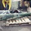
Two cannons raised from the wreck were retained by Richard Price, the remainder and majority of finds recovered are held at Shetland Museum. RCAHMS holds a small number of photographs, manuscripts and drawings. The site was designated under the Protection of Wrecks Act in 1990.
Information from RCAHMS (HDS and GFG) 16 October 2012
Bound, M and Sharpe, T 1995
Loss (23 July 1687)
External Reference (15 August 1990)
WRANGELS PALAISE: Designated Historic Wreck Site.
Locational information from V Turner, Shetland Amenity Trust, 15 August 1990.
Diver Inspection (13 August 1990)
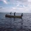
This wreck was discovered on the 13th August 1990 by Tim Sharpe of Strathclyde University Sub Aqua Club during an exploratory dive. Two cannons were raised immediately after discovery and are retained by Richard Price.
Information from RCAHMS (HDS) 11 December 2012
Source: Bound, M and Sharpe, T 1995
Two cannons raised from this wreck in 1990 are retained by Mr R Price (Alyth). The artifacts recovered by Bound and Sharpe are held in Shetland Museum: these await listing and formal accession.
NMRS, MS/829/65.
Diver Inspection (1991)
An inspection of the wreck was scheduled in 1991 after a licence was obtained by Richard Price at which point two guns were found in shallow water.
Information from RCAHMS (HDS) 11 December 2012
Source: NMRS MS/2460
Diver Inspection (1993)
The 1993 season of work (by Strathclyde University Sub-Aqua Club under T Sharpe, M Bound and R Price) aimed to conduct pre-disturbance survey of the remains. In the event, guns on the periphery of the site were not surveyed for lack of time, and the locations of individual cannonballs were not recorded. 28 guns were identified and 23 of these were accurately recorded. The relatively small number of guns identified remains surprising, and may suggest that more of the wreck survives in deeper water, possibly beyond the limit of air diving.
NMRS, MS/829/64.
Diver Inspection (28 July 1994 - 11 August 1994)
The site was resurveyed in 1994 by the Strathclyde University Sub Aqua Club.
Information from RCAHMS (HDS) 11 December 2012
Source: MS/2460
Reference (1994)
The Out Skerries are a group of small islands about 30 miles E of the Shetland Isles. Owing to their prominent easterly situation and relative small size, they pose a significant risk to vessels leaving the North Sea by the 'north about' route.
The possible existence of the wreck of the Danish frigate Wrangels Palais was first noted by Robert Stewart Bruce of Symbister in the 'Bruce Papers', in which he recorded many of the oral traditions of outlying communities relating to shipwrecks, supplemented in many cases by background research. In this case, he gained additional information from the Danish Imperial Archives, although it seems many of the papers relating to the vessel had been lost. The 'Bruce Papers' were rescued by the late Tom Henderson, the first curator of the Shetland Museum, who secured for Shetland Islands Council a lease on the seabed around Capped Lamba Stack, where Bruce believed the vessel had struck.
The 'Bruce Papers' record that the vessel was originally a Swedish merchantman built in 1662 in Holland, bought for the Swedish navy in 1669, and captured by the Dames at Moen in 1677, being subsequently converted into a frigate. The 'List of Danish-Norwegian Ships, 1650-1700' records her as having between 38 and 46 guns. Records of her dimensions vary between 107ft by 25ft 6ins by 11ft 6ins (32.6 by 7.8 by 3.5m) and 125ft by 37ft (38.1 by 11.3m); the first Danish measurements are more likely to be correct. The ship was named after the 'Wrangels Palais' in Stockholm, built by Carl Gustav Wrangel. She had a nominal complement of 253, but there were apparently only 240 on board when she was wrecked. Of this number, 87 were drowned including her captain, Joseph Roelack. The vessel was recorded as being totally lost off Capped Lamba Stack on 23 July 1687, during a 'thick fog'. She had been patrolling in the area between Iceland and the Faeroes with five other men-of-war to protect the population against thirteen Turkish privateers.
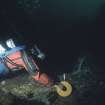
The remains of the wreck were discovered in 1990 by Tim Sharpe, while on an expedition organised by Richard Price, who had been looking for the wreck for nineteen years. He had dived on the E tip of Bound Skerry and was following the contour to the S at 26m depth, when he came across a 'basin filled with cannon'. Two of these were of bronze, a date (1677) being clearly visible on one of them. They clearly formed a pair, measuring 2370 and 2375mm in length respectively; each appeared to bear a cartouche in relief with a cypher between breech and trunnions. A sketch plan of the remains was subsequently drawn; the bronze guns were passed and passed to the Receiver of Wreck.
The remains were Designated ('scheduled') under the Protection of Wrecks Act (1973) on 15 August 1990. This precluded any immediate further investigations. In 1991 Richard Price obtained a licence for search and survey operations, but bad weather allowed only a limited dives around the margin of the remains. Two further guns were found in shallower water.
In 1993, Tim Sharpe (Strathclyde University Sub-Aqua Club), Mensun Bound (Oxford University Mare) and Richard Price were granted a survey licence. The survey identified 31 guns and recorded 22 of these on a site plan. This work was continued by Sharpe and Bound between 28 July and 11 August 1994, and with broader objectives based around the completion of a pre-disturbance survey. Search dives around the periphery revealed only an iron fragment about 200mm long some 100m away.
The site was defined as lying in between 25 and 28m depth of water at the base of a steep cliff on the S side of easternmost point of Broad Skerry, and at a location of N60 25.5 W0 43.27 [HU 7040 7185]. The horizontal extent of the site from the cliff face (along the surface) is only 35m. The proximity of the cliffs makes this a 'high-energy' site [environment] on the surface in anything over Force 4. Underwater, however, the point deflects away the underwater currents that run at over 4kts [2.1m/sec] only 10m from the remains. Little evidence was noted of undue natural movement, tags from the previous season remaining loose on the site. The possible removal of a cannonball was noted, and the wreck is said to have been visited by other divers.
A comparison was made between the topography of the site and its surrounding area. On either side and below the site, the seabed generally comprises exposed volcanic rock which slopes gently upwards from 50m to, on average, 25m, where it rises to form the cliffs of Bound Skerry. Boulders and rubble are found only on the site itself, where the rock-type appears to differ from the bedrock. Above sea level, there is a stratum of igneous rock with more sedimentary rock on top. The boulders and stones have fallen onto the site from the large cleft above, probably burying many of the cannon and suggesting that other artifacts lie buried. The depth of loose material across the site was not determined, while the use of a proton magnetometer revealed no anomalies of evident significance.
The visible shot was examined and photographed. Diameters of between 100 and 150mm were noted, while some scattered fragments indicate diameters of up to 200mm. All were concreted and abraded, precluding accurate recording. A possible broken shell of 100mm diameter (with a wall 5mm thick) was noted.
In all, 36 ferrous 'items' [presumably artifacts] were recorded; some of these may have been fragments of the same artifact. The eroded timber fragments noted in 1993 remained visible; further examples were noted. Further 'ancillary' material may survive below the stones and rubble.
The equation of the remains with the documented loss of the Wrangels Palais was accepted on account of their proximity (c. 750m) to the traditional location of striking (Lamba Stack, up-current), together with the nature, quantity and date of the armament.
(Includes numbered summary list of guns, possible anchor and fragments found. Illustrated with maps, plans and sections, drawings and photographs. Expedition log sheets reproduced and administrative details cited, with summary of expedition accounts).
NMRS, MS/2460.
Reference (1995)
This cannon wreck was discovered on 13 August 1990 by T Sharpe of Strathclyde University SAC during exploratory archaeological survey. It lies in between 25 and 28m depth of water at the base of a steep cliff on the S side of the E point of Bound Skerry. No structural remains or other artifacts were apparently discovered in a high-energy environment.
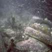
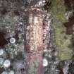
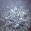
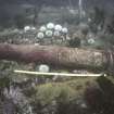
The site comprised a 'basin' shaped area of bed-rock containing a large number of iron guns and two bronze guns (one clearly dated 1677). The two bronze guns were recovered from the main concentration immediately after the discovery, in an operation which entailed the disturbance one of the iron guns from its original position.
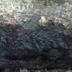
The deposit within the western two thirds of the basin comprises eighteen concreted iron guns and associated shot. The guns are mixed with, and in some cases partially covered by, the boulders and rocks that have come down the submerged cliff. Twelve of them lie roughly side by side with their ends pointing in opposite directions, while five are situated in the immediate vicinity to the south and another five in shallower (9m) water on the periphery. The condition of the guns is mixed with the concreted surface deposits being typically badly abraded. Scattered between the guns are at least 177 pieces of iron shot of 100-150mm diameter while the main concentration of shot (forming one large concretion) is situated in the NW corner of the basin.
Further survey in 1991 (licensed by the Secretary of State under the terms of the Protection of Wrecks Act 1973) found two, small, badly worn iron guns to the SW of the main deposit.
From 8-22 July 1993 Oxford University MARE and Strathclyde University Sub-Aqua Club carried out a survey of the site, mapping the visible remains and producing plans which also showed the previous positions of the recovered bronze guns and the displaced iron gun.
The remains have been convincingly identified as those of the Wrangels Palais on the material evidence of the guns (one of which bears the date 1677) and their location in relation to Lamba Stack (where the vessel is recorded as striking).
The wreck has been recorded historically by Mr R S Bruce of Symbister (papers held in the Shetland Museum, Lerwick). The ship was originally a Swedish merchant vessel (built in 1669 for the Swedish navy as the Wrangels Pallats) but was captured by the Danes in 1677. At the time of sinking, she was in company with five other [named] ship, forming a squadron under Vice-Admiral Frederick Geddes with orders to patrol 'in the North Sea between the Faroe Islands and Iceland' to guard against a group of thirteen Turkish privateers. She carried a complement of 240 under Captain J G Roelack and two lieutenants, of whom 88 and 140 are variously said to have been lost when the ship struck the Tapped Lamba Stack. The events surrounding the loss were subsequently recorded at court martial.
This wreck is significant as representing the conflict in Northern waters (and particularly around Shetland) between the ships of the various European nations in the 17th and 18th centuries, when the activities of the various East India companies were at their peak. The discovery of only 33 guns out of about 46 originally carried may suggest that the vessel broke in two, leaving a further portion in deep water or near Lamba Stack.
[Location maps, site plan, artist's schematic impression of excavations and table of particulars of guns published. The present location of the guns recovered is not stated].
Summery by RCAHMS (RJCM) Undated
Source: M Bound and T Sharpe 1995.
External Reference (1998)
Wrangels Palais: [max. date] 1687.
44 guns 107'x 25.6'x 11 6'. Cruising with 4 others between Faroe and Iceland. 88 of 240 crew perished. Originally a Swedish merchantman called the Wrangels Pallats. Bought for the Swedish Navy in 1669 and captured by the Danes in 1677.
Archive Ref: RSB.
Source: Shetland Archive Service [1998].
MS/3025, no. 145.
Note (24 January 2003)
The cited location falls just beyond the east side of Bound Skerry, about 260m E of the lighthouse HU77SW 1. Neither the charted date nor the seabed type is indicated on the available chart, but the remains are evidently situated close to a steep dropoff into deep water to the N, E and S. The location is also highly exposed in all these directions.
Information from RCAHMS (RJCM), 24 January 2003.
HO chart no. 1233 (1982, revised 1993).
External Reference (2004)
(Wrangels Palais: site no. 36). This site is significant as one of the increasingly rare examples of a scattered wreck untouched by contemporary salvage or recent interference.
Advisory Committee on Historic Wreck Sites 2004.
Note (6 September 2005)
The rig of this vessel is apparently unrecorded.
Information from RCAHMS (RJCM), 6 September 2005.
Side Scan Sonar Survey (23 September 2011 - 25 September 2011)
Wessex Archaeology was commissioned by Historic Scotland to undertake geophysical survey over a number of wreck sites off the coast of Shetland; in total eight wrecks were surveyed in detail by side scan sonar. A further three sites were visited but unable to be surveyed due to bad weather. Of the eight wreck surveys only one survey did not reveal any geophysical anomalies of archaeological interest, this was the Aith Voe Hull, a named location. Three wreck surveys identified definite archaeological anomalies and the remaining four wreck surveys identified numerous geophysical anomalies, some of them of archaeological potential. The surveys have informed upon the environment and condition of the wrecks and quantitative information has been added to the body of work already existing.
The eight wrecks include Wrangels Palais, Gwladmena, Glenisla, Drottingen af Swerige, HMS Cheerful and three unknown possibly including MTB 686.
Geophysical Survey (23 September 2011 - 25 September 2011)
Wessex Archaeology was commissioned by Historic Scotland to undertake geophysical survey over a number of wreck sites off the coast of Shetland; in total eight wrecks were surveyed in detail by side scan sonar. A further three sites were visited but unable to be surveyed due to bad weather.
Of the eight wreck surveys only one survey did not reveal any geophysical anomalies of archaeological interest, this was the Aith Voe Hull, a named location. Three wreck surveys identified definite archaeological anomalies and the remaining four wreck surveys identified numerous geophysical anomalies, some of them of archaeological potential. The surveys have informed upon the environment and condition of the wrecks and quantitative information has been added to the body of work already existing.
In addition multibeam bathymetry data were acquired from the UKHO (United Kingdom Hydrographic Office) and processed and interpreted by Wessex Archaeology. The multibeam bathymetry data analysis identified fine anomalies of potential archaeological interest and showed the presence of partially infilled palaeochannels, glimpsing the submerged prehistory of Shetland. The context for these palaeochannels is summarised and further work suggested to build on this.
Information from OASIS ID: waherita1-298431 (P Baggaley) 2011
Reference (2011)
Whittaker ID : 7326
Name : WRANGELS PALAIS (EX. WRANGELS PALLATS)
Latitude : 602530
Longitude : 4330
Registration : DANISH
Type : FRIGATE 46 GUN
Length : 38
Beam : 11
Loss Day : 23
Loss Month : 7
Loss Year : 1687
Comment : Wrecked on Lamda Stack, carried onto Bound Skerry, Out Skerries. Capt. Roelack
Reference (19 April 2012)
UKHO Identifier : 000144
Feature Class : Wreck
State : LIVE
Status : Historic
Classification : Unclassified
Position (Lat/long) : 60.42500,-0.72111
Horizontal Datum : ORDNANCE SURVEY OF GREAT BRITAIN (1936)
WGS84 Position (Lat/long) : 60.42445,-0.72313
WGS84 Origin : 3-D Cartesian Shift (BW)
Position Quality : Precisely known
Depth Quality : Depth unknown
Water Depth : 30
Vertical Datum : Lowest Astronomical Tide
Name : WRANGELS PALAIS (PROBABLY).
Type : 46 GUN WARSHIP
Flag : DANISH
Length : 38.1
Beam : 11.3
Date Sunk : 23/07/1687
Contact Description : Notable debris
Original Sensor : Other
Original Detection Year : 1990
Original Source : Other
Circumstances of Loss : **SANK AFTER STRIKING A ROCK, IN THICK FOG, WHILE CHASING BARBARY PIRATES. CONTEMPORARY COURT MARTIAL RECORDS SURVIVE. (ADU).
Surveying Details : **HA141/02/01/02 6.9.90 AREA 100MTRS RADIUS CENTRED ON 602230N, 004316W [OGB] DESIGNATED AS A MATTER OF URGENCY AS RESTRICTED AREA UNDER PROVISIONS OF PROTECTION OF WKS ACT, 1973. WRECK TENTATIVELY IDENTIFIED AS DANISH 46 GUN WARSHIP WRANGELS PALAIS, WHICH SANK 1687. (DEPT OF TRANSPORT, 21.8.90). PLOTS IN 100MTRS - POSN QUERIED. LATITUDE SHOULD READ 602530N. SOME BRONZE CANNON WERE LIFTED BEFORE SITE DESIGNATED. (A MARGETTS, DOT, TELECON). NCA.
**HA141/02/01/02 23.1.91 AREA, 100MTRS RADIUS, CENTRED ON 602530N, 004316W [OGB] DESIGNATED AS PROTECTED WRECK SITE. (STATUTORY INSTRUMENT NO.2573 OF 1990). INS AS HISORIC WK WITH RESTRICTED AREA RADIUS 100MTRS. - NM 316/91.
POSITIONS BELOW THIS POINT ARE IN DEGREES, MINUTES AND DECIMALS OF A MINUTE
Chart Symbol : WK HIS
Charting Comments : REST'D AREA RADIUS 100MTRS. WK NOT CHARTED
Date Last Amended : 11/03/1999
Management (1 November 2013)
The following Historic Marine Protected Area (HMPA) designations will come into force on 1 November 2013. On the same day Section 1 of the Protection of Wrecks Act (1973) will be repealed and the statutory instrument for each designation under the 1973 Act will be revoked – see
Marine (Scotland) Act 2010 (Commencement No.3 and Consequential Provisions Order 2013
http://www.legislation.gov.uk/ssi/2013/276/contents/made
(1) The Duart Point Wreck (NM73NW 8005) is to be designated as the Duart Point HMPA
(2) The Dartmouth (NM74SW 8002) is to be designated as the Dartmouth HMPA
(3) The Mingary Castle Wreck (NM56SW 8001) is to be designated as the Mingary HMPA
(4) HMS Campania (NT28SW 8001) is to be designated as the Campania HMPA
(5) The Kinlochbervie Wreck (NC15SE 8001) is to be designated as the Kinlochbervie HMPA
(6) The Wrangels Palais (HU77SW 8001) and Kennemerland (HU67SE 8001) will be designated as the Out Skerries HMPA (ie two polygons making up one designation).
Also on 1 November 2013, the urgent designation of the Drumbeg wreck (NC13SW 8007) on 18 March 2013 for a period of two years under the provisions of Section 77 of the Marine (Scotland) Act 2010 is to be revoked and replaced by a permanent HMPA designation order.
As it will not progress to Historic MPA status, statutory protection for the site of the Blessing of Burntisland (NT28SW 8008) is to be revoked altogether on 1 November 2013 by virtue of
The Marine (Scotland) Act 2010 (Commencement No. 3 and Consequential Provisions) Order 2013
http://www.legislation.gov.uk/ssi/2013/276/contents/made
Entered by RCAHMS (GF Geddes) 29 October 2013
Information from Historic Scotland (P Robertson) 15 October 2013
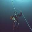
Diver Inspection (8 June 2014 - 15 June 2014)
In June 2014 a Cotswold Archaeology dive team undertook a survey of the wreck of the Wrangels Palais off Out Skerries, Shetland. The work was conducted as part of the Heritage Assessment in Relation to Marine Designation: Scottish, Welsh and Northern Irish Territorial Waters contract. It was undertaken to a brief supplied by Historic Scotland. The Wrangels Palais was built as the Wrangles Palats in the Netherlands in 1662. She was bought by a Swedish company and worked as a merchant vessel until being bought into the Swedish navy in 1669. The vessel saw action during the Scanian War (1675-1679) fought between Sweden and a Danish-Norwegian alliance. On the first day of the battle of Møn, fought between a Danish force and a smaller Swedish squadron, the Wrangles Palats (listed as 38 guns) was overtaken and captured by the 62-gun Enigheden. Following her capture she was commissioned into the Danish navy as a frigate and renamed the Wrangels Palais.
On the 23rd July 1687 the Wrangels Palais was patrolling between Iceland and the Faeroe Islands to guard against Turkish privateers when, in dense fog, she struck Capped Lamba Stack and sank. Of the 240 men on board, c. 87 were drowned. The wreck was found in 1990 by Tim Sharpe diving as part of an expedition organised by Richard Price. On 18th August 1990 the site was designated under the Protection of Wrecks Act (1973) and between 1993 and 1995 work was undertaken on the site. The Strathclyde University dive team conducted investigations, led by Tim Sharpe, with input from Richard Price and Mensun Bound. The wreck site consists of a cluster of iron and bronze cannons (31 were reported in 1994) and iron concretions sitting on a rocky seabed.
Diving operations took place between 8th and 15th June 2014. The primary objective was to locate surviving elements of the wreck, position-fix them and thus achieve an up-to-date plan of seabed remains for comparison against the previous archaeological plans. The objectives were achieved for most of the features shown on the previous plans. The work also allowed the sidescan data collected by Wessex Archaeology in 2011, and which shows the site clearly, to be correctly positioned.
Cotswold Archaeology, January 2015

