|
Photographs and Off-line Digital Images |
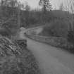
A 54756 |
Records of the Ordnance Survey, Southampton, Hampshire, England |
|
1971 |
Item Level |
|
|
Photographs and Off-line Digital Images |
A 54757 |
Records of the Ordnance Survey, Southampton, Hampshire, England |
|
1971 |
Item Level |
|
|
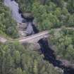
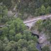
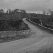
Photographs and Off-line Digital Images |
B 80294 CS |
|
Aerial view. |
1989 |
Item Level |
|
|
Photographs and Off-line Digital Images |
N 154 |
Photographs by Mrs E M Booty, Clydemore, England |
View from W. |
1920 |
Item Level |
|
|
Manuscripts |
MS 1007/7 |
Mairi Logie |
Coupar Angus to Fort George (and the northern link roads). An assessment of the 18th century military roads which lie within the Highland Council boundaries. |
1997 |
Item Level |
|
|
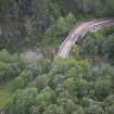
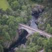
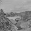
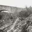
Photographs and Off-line Digital Images |
C 7312 |
|
General view of bridge and gorge from W.
|
|
Item Level |
|
|
Print Room |
D 80512 PC |
Collection of photographs and postcards by J Valentine and Sons Ltd, photographers, Dundee, Scotland |
Postcard.
General view. |
|
Item Level |
|
|
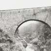
Print Room |
D 80511 PC |
Records of Ian Gordon Lindsay and Partners, architects, Edinburgh, Scotland |
Postcard.
General view. |
|
Item Level |
|
|
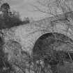
Print Room |
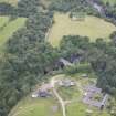
RAB 453/21 |
General Collection |
Dulsie Bridge. Dulsie Inn visible upper left. 1799. |
1819 |
Item Level |
|
 |
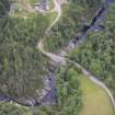
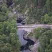
On-line Digital Images |
DP 264965 |
Historic Environment Scotland |
Oblique aerial view. |
9/8/2017 |
Item Level |
|
 |
On-line Digital Images |
DP 264966 |
Historic Environment Scotland |
Oblique aerial view. |
9/8/2017 |
Item Level |
|
 |
On-line Digital Images |
DP 264967 |
Historic Environment Scotland |
Oblique aerial view. |
9/8/2017 |
Item Level |
|
 |
On-line Digital Images |
DP 264968 |
Historic Environment Scotland |
Oblique aerial view. |
9/8/2017 |
Item Level |
|
 |
On-line Digital Images |
DP 264969 |
Historic Environment Scotland |
Oblique aerial view. |
9/8/2017 |
Item Level |
|
 |
On-line Digital Images |
DP 264970 |
Historic Environment Scotland |
Oblique aerial view. |
9/8/2017 |
Item Level |
|
 |
On-line Digital Images |
DP 264971 |
Historic Environment Scotland |
Oblique aerial view. |
9/8/2017 |
Item Level |
|
 |
On-line Digital Images |
DP 264972 |
Historic Environment Scotland |
Oblique aerial view. |
9/8/2017 |
Item Level |
|
 |
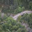
On-line Digital Images |
SC 1847122 |
Scottish Development Department |
Dulsie Bridge, Ardclach parish, Nairn, Highland |
28/4/1982 |
Item Level |
|
 |
On-line Digital Images |
SC 1847123 |
Scottish Development Department |
Dulsie Bridge, Ardclach parish, Nairn, Highland |
28/4/1982 |
Item Level |
|
 |
On-line Digital Images |
SC 1847124 |
Scottish Development Department |
Dulsie Bridge, Ardclach parish, Nairn, Highland |
28/4/1982 |
Item Level |
|
 |
On-line Digital Images |
SC 1847125 |
Scottish Development Department |
Dulsie Bridge, Ardclach parish, Nairn, Highland |
28/4/1982 |
Item Level |
|
 |
On-line Digital Images |
SC 1847133 |
Scottish Development Department |
Dulsie Bridge, Ardclach parish, Nairn, Highland |
28/4/1982 |
Item Level |
|
 |
On-line Digital Images |
SC 2564730 |
Records of the Ordnance Survey, Southampton, Hampshire, England |
|
1971 |
Item Level |
|
 |
On-line Digital Images |
SC 2564731 |
Records of the Ordnance Survey, Southampton, Hampshire, England |
|
1971 |
Item Level |
|


