
Huxter, Norse Mill


Horizontal Mill (18th Century)
Site Name Huxter, Norse Mill
Classification Horizontal Mill (18th Century)
Alternative Name(s) Huxter 2
Canmore ID 69376
Site Number HU15NE 25
NGR HU 17273 57129
Datum OSGB36 - NGR
Permalink http://canmore.org.uk/site/69376


- Council Shetland Islands
- Parish Walls And Sandness
- Former Region Shetland Islands Area
- Former District Shetland
- Former County Shetland
The Norse, or horizontal, mills at Huxter are typical examples of a once-common type of water mill found in Shetland, Orkney and Lewis. The mill used one wheel (tirl) with blades mounted on a horizontal plane, driving a single pair of grindstones. This simple design meant that multiple mills could be built on a length of stream, with a family or small partnership each owning their own mill.
Information from RCAHMS (SC) 8 August 2007
Hume, J 1977
HU15NE 25 17273 57129
HU15NE 68 17253 56965 Huxter Loch, Dam
Field Visit (14 August 1981)
Publication Account (1986)
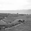
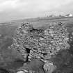
These buildings form a chain of three mills on the burn that empties from the Loch of Huxter into the Sound of Papa. The mills are grouped within a short distance of about 75m, with the site of a fourth mill, now demolished, a similar distance upstream [HU15NE 19]. They are served by short stone-lined lades, cutting off meanders in the burn, and there is a fall of some 8.2m between the floor levels of the top and bottom mill. All the buildings are aligned across the lade with the water-courses running transversely beneath the side-walls.
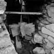
The two upper structures survive as masonry shells, but the lowest building retains its heather-and straw-thatched gabled roof. It is oblong on plan, averaging 18 ft (5.49m) in length by 9 ft 6 in (2.90m) transversely over walls 2 ft (0.61m) thick; the entrance is in the E gable-wall. It still has the wooden chute, or pentrough, for directing the water onto the tirl in a clockwise direction. The tirl is of concrete, but an original specimen survives in one of the other mills. This consists of a wooden, elongated barrel-shaped hub (nave) with nine flat paddles. The lower mill also retains a pair of millstones, the bedstone (understone) being 2 ft 9 1/2 in (0.85m) in diameter and 5 1/8 in (130mm) thick, the runner stone (upperstone) slightly less in each dimension. Until a few years ago it was complete with a square wooden hopper. The drawing is intended to be a general representation of a horizontal mill, based on the Huxter examples and documentary sources.
Information from RCAHMS ‘Monuments of Industry: An Illustrated Historical Record’, (1986). Visited 1980.
Publication Account (1997)
The burn runs only a short distance from a small loch to the sea, but it falls steeply in its lower reaches, creating ideal conditions for small mills, and the loch itself has an excellent feeder burn that falls from a height of some 200m OD in the hills to the south-east. There are three mills in the steeply cut lower reaches of the burn, the last of which went out of regular use during World War II but was kept in good order until recently.
Each mill is arranged identically on the burn: the mill itself is built astride the direct route of the water-course, with a wide meander round it on the west side into which the water could be diverted, when the mill was idle, by means of sluice-gates. The timber gates are missing but their vertical slots are visible. Each rectangular building is about 5.5m by 3m, with an entrance only 0.6m wide in the east gable, and the roof surviving on the lowest mill consists of heather thatch over turf and branches carried on a wooden frame. The little window over the door of this mill is very unusual and likely to have been a late modification. This last mill still has its millstones, and all three have remains of their horizontal wooden water-wheels, that in the uppermost mill retaining six of its original nine blades or feathers. The la des are beautifully constructed with stone linings, feeding the water into wooden chutes which direct it on to the inclined feathers of the wheels.
It is worth following the burn up to the Loch of Huxter to see the well-constructed stone dam and oncrere sluice-gate setting, the stones for the dam almost certainly robbed from the adjacent broch. The latter has a recent sheep stell built on top of it, but the outer base of the broch wall is visible on the loch side, the broch entrance with a lintel still in position is incorporated into the stell, and, on the south side, the sheep are clearly using the broch entrance passage and the entrance into a guard cell as a means of getting in and out of the stel!. To the south of the loch are two burnt mounds which, unusually, have been given names: Little Brownie's Knowe (HU 173566) and Muckle (Big) Brownie's Knowe (HU 171563). There is a magnificent view to the north of the island of Papa Stour, on which an important late Norse settlement has been discovered and partially excavated at Da Biggings.
Information from ‘Exploring Scotland’s Heritage: Shetland’, (1997).

