
Following the launch of trove.scot in February 2025 we are now planning the retiral of some of our webservices. Canmore will be switched off on 24th June 2025. Information about the closure can be found on the HES website: Retiral of HES web services | Historic Environment Scotland
Pitmudie


Building(S) (Medieval) - (18th Century), Track(S) (Medieval) - (18th Century)
Site Name Pitmudie
Classification Building(S) (Medieval) - (18th Century), Track(S) (Medieval) - (18th Century)
Canmore ID 68712
Site Number NO56NW 55.02
NGR NO 5498 6674
Datum OSGB36 - NGR
Permalink http://canmore.org.uk/site/68712


- Council Angus
- Parish Menmuir
- Former Region Tayside
- Former District Angus
- Former County Angus
Field Visit (31 October 1989)
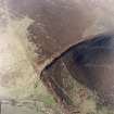
NO56NW 55.02 5498 6674.
Some 500m SE of Pitmudie there are the remains of up to three rectangular buildings defined by rubble footings 0.7m thick and up to 0.4m high. Building 1 (NO 5498 6674), set between two hollow trackways, measures 8.5m from N to S by 4m overall; building 2 (NO 5499 6673) measures 6.5m from NW to SE by 4m overall and building 3 (NO 5499 6673), the footings of which are slighter and less well-defined, measures 12m from N to S by 4m transversely; the W side of this building has been destroyed by a trackway. Further trackways are visible to the NE.
Visited by RCAHMS (DCC) 31 October 1989.

